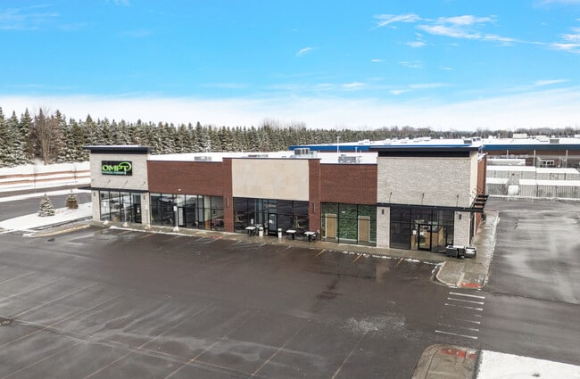
Property Record
57388 Van Dyke Rd, Washington, MI 48094


Save to a Folder
{{folder.Name}}
{{folder.ListingIds.length}} Properties
{{folder.ListingIds.length}} Property
Create a New Folder
Current Lease Availabilities
Property Detail
57388 Van Dyke Rd
24-04-34-351-021
24-04-34-351-021 LEGAL DESCRIPTION (OUTLOT A) T4N R12E SEC 34; COMM AT SW COR SEC 34; TH N00*05'00" E 693.04 FT; TH
Commercialnec
MACOMB
CONSENT-GC
Michigan
B and X Area of moderate flood hazard, usually the area between the limits of the 100-year and 500-year floods.
1.63 AC
2025
St Clair & Lapeer Counties
2026
Detroit
215300
Detroit-Warren-Dearborn, MI
9,856 SF
NEARBY LISTINGS FOR SALE OR LEASE
DEMOGRAPHICS near 57388 Van Dyke Rd
1 mile
3 mile
5 mile
2025 Total Population
9,586
47,267
113,619
2030 Population
9,786
48,159
115,703
Pop Growth 2025-2030
+ 2.09%
+ 1.89%
+ 1.83%
Average Age
41
43
43
2025 Total Households
3,788
18,095
42,339
HH Growth 2025-2030
+ 2.01%
+ 1.88%
+ 1.78%
Median Household Inc
$89,485
$103,797
$105,930
Avg Household Size
2.50
2.60
2.60
2025 Avg HH Vehicles
2.00
2.00
2.00
Median Home Value
$341,568
$424,346
$401,073
Median Year Built
1995
1994
1994
Nearby Places
Map Layers
Map Styles
 Street
 Aerial
Layers
 Traffic
 Biking
Places
Listings with unknown addresses are not visible on the map
- Restaurants
- Banks
- Shops
- Fitness
- Groceries
Nearby Properties
Address
Land Use
TOTAL SIZE
Lot Size
Zoning
Address
Land Use
TOTAL SIZE
Lot Size
Zoning
371,520 SF
21.91 AC
CK MAP
Address
Land Use
TOTAL SIZE
Lot Size
Zoning
257,878 SF
30 AC
Address
Land Use
TOTAL SIZE
Lot Size
Zoning
29,394 SF
33.83 AC
CK MAP
Address
Land Use
TOTAL SIZE
Lot Size
Zoning
160,104 SF
22.98 AC
CONSENT-R1
Address
Land Use
TOTAL SIZE
Lot Size
Zoning
117,856 SF
13.51 AC
C-3
Address
Land Use
TOTAL SIZE
Lot Size
Zoning
10.28 AC
CK MAP
Address
Land Use
TOTAL SIZE
Lot Size
Zoning
9.47 AC
R-9
Address
Land Use
TOTAL SIZE
Lot Size
Zoning
8.81 AC
C-6
Address
Land Use
TOTAL SIZE
Lot Size
Zoning
234,542 SF
38.35 AC
LM
Address
Land Use
TOTAL SIZE
Lot Size
Zoning
217,654 SF
30.21 AC
CONSENT-GC
Address
Land Use
TOTAL SIZE
Lot Size
Zoning
960 SF
19.11 AC
R-8
Address
Land Use
TOTAL SIZE
Lot Size
Zoning
125,426 SF
13.23 AC
R-1-B
Address
Land Use
TOTAL SIZE
Lot Size
Zoning
134,400 SF
7.55 AC
CK MAP
Address
Land Use
TOTAL SIZE
Lot Size
Zoning
128,299 SF
6.92 AC
V1
Address
Land Use
TOTAL SIZE
Lot Size
Zoning
108,799 SF
26 AC
CONSENT-R1
Address
Land Use
TOTAL SIZE
Lot Size
Zoning
188,047 SF
24.98 AC
RM2
Address
Land Use
TOTAL SIZE
Lot Size
Zoning
118,844 SF
17.80 AC
C-2
Address
Land Use
TOTAL SIZE
Lot Size
Zoning
122,540 SF
CK MAP
Address
Land Use
TOTAL SIZE
Lot Size
Zoning
152,601 SF
13.98 AC
RM2
Address
Land Use
TOTAL SIZE
Lot Size
Zoning
90,519 SF
4.12 AC
V1
Address
Land Use
TOTAL SIZE
Lot Size
Zoning
61,573 SF
6.97 AC
C-3
Address
Land Use
TOTAL SIZE
Lot Size
Zoning
194,122 SF
19.33 AC
V1
Address
Land Use
TOTAL SIZE
Lot Size
Zoning
29.03 AC
CK MAP
Address
Land Use
TOTAL SIZE
Lot Size
Zoning
9.01 AC
R-12
Address
Land Use
TOTAL SIZE
Lot Size
Zoning
95,977 SF
4.24 AC
V1
Address
Land Use
TOTAL SIZE
Lot Size
Zoning
112,512 SF
6.40 AC
CONSENT-R1
Address
Land Use
TOTAL SIZE
Lot Size
Zoning
18,361 SF
30 AC
Address
Land Use
TOTAL SIZE
Lot Size
Zoning
9.84 AC
R-9
Address
Land Use
TOTAL SIZE
Lot Size
Zoning
105,929 SF
8.04 AC
CONSENT-R1
Address
Land Use
TOTAL SIZE
Lot Size
Zoning
119,804 SF
12.48 AC
R-1-B
The World's #1 Commercial Real Estate Marketplace
Connect with us
© 2026 CoStar Group
The information above has been obtained from sources believed reliable. While we do not doubt its accuracy we have not verified it and make no guarantee, warranty or representation about it. It is your responsibility to independently confirm its accuracy and completeness. Any projections, opinions, assumptions, or estimates used are for example only and do not represent the current or future performance of the property. The value of this transaction to you depends on tax and other factors which should be evaluated by your tax, financial, and legal advisors. You and your advisors should conduct a careful, independent investigation of the property to determine to your satisfaction the suitability of the property for your needs.