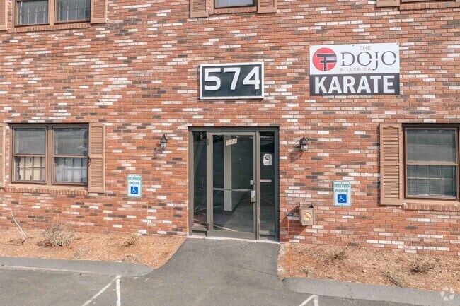
Property Record
574 Boston Rd, Billerica, MA 01821
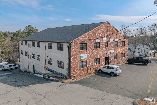
This Property Is For Sale
Current Lease Availabilities
NEARBY LISTINGS FOR SALE OR LEASE
Property Detail
574 Boston Rd
Officecondo
Middlesex
X
Massachusetts
25017C0267F
10
2025
Lowell/Chelmsford
2025
Boston
316102
Boston-Cambridge-Newton, MA-NH
980 SF
BILL-000070-000116-000012
DEMOGRAPHICS near 574 Boston Rd
1 Mile
3 Mile
5 Mile
2024 Total Population
7,389
46,164
121,198
2029 Population
7,286
45,704
120,057
Pop Growth 2024-2029
(1.39%)
(1.00%)
(0.94%)
Average Age
42
42
43
2024 Total Households
2,830
16,503
43,631
HH Growth 2024-2029
(1.48%)
(1.02%)
(1.01%)
Median Household Inc
$112,330
$131,135
$127,977
Avg Household Size
2.50
2.70
2.70
2024 Avg HH Vehicles
2.00
2.00
2.00
Median Home Value
$473,664
$546,491
$607,665
Median Year Built
1973
1972
1972
Nearby Places
Map Layers
Map Styles
 Street
 Aerial
- Restaurants
- Banks
- Shops
- Fitness
- Groceries
PUBLIC TRANSPORTATION
COMMUTER RAIL
North Billerica (Lowell Line - Massachusetts Bay Transportation Authority Commuter Rail (Purple Line))
DRIVE
WALK
Distance
North Billerica (Lowell Line - Massachusetts Bay Transportation Authority Commuter Rail (Purple Line))
9 min
3.9 mi
Wilmington (Lowell Line - Massachusetts Bay Transportation Authority Commuter Rail (Purple Line))
DRIVE
WALK
Distance
Wilmington (Lowell Line - Massachusetts Bay Transportation Authority Commuter Rail (Purple Line))
14 min
6.5 mi
AIRPORT
General Edward Lawrence Logan International
DRIVE
WALK
Distance
General Edward Lawrence Logan International
37 min
22.5 mi
Manchester Boston Regional
DRIVE
WALK
Distance
Manchester Boston Regional
54 min
36.2 mi
Worcester Regional
DRIVE
WALK
Distance
Worcester Regional
68 min
49.5 mi
Nearby Properties
Address
Land Use
TOTAL SIZE
Lot Size
Zoning
Address
Land Use
TOTAL SIZE
Lot Size
Zoning
35.90 AC
5
Address
Land Use
TOTAL SIZE
Lot Size
Zoning
253,078 SF
4.18 AC
5
Address
Land Use
TOTAL SIZE
Lot Size
Zoning
325,799 SF
21.70 AC
IND
Address
Land Use
TOTAL SIZE
Lot Size
Zoning
225,792 SF
9.90 AC
4
Address
Land Use
TOTAL SIZE
Lot Size
Zoning
9.50 AC
Address
Land Use
TOTAL SIZE
Lot Size
Zoning
27.48 AC
5
Address
Land Use
TOTAL SIZE
Lot Size
Zoning
504,154 SF
19.40 AC
2
Address
Land Use
TOTAL SIZE
Lot Size
Zoning
20,382 SF
11.61 AC
IND
Address
Land Use
TOTAL SIZE
Lot Size
Zoning
244,756 SF
15.91 AC
5
Address
Land Use
TOTAL SIZE
Lot Size
Zoning
102,899 SF
28.88 AC
IND
Address
Land Use
TOTAL SIZE
Lot Size
Zoning
189,960 SF
7.88 AC
4
Address
Land Use
TOTAL SIZE
Lot Size
Zoning
16.63 AC
2
Address
Land Use
TOTAL SIZE
Lot Size
Zoning
30,578 SF
13.22 AC
R
Address
Land Use
TOTAL SIZE
Lot Size
Zoning
110,162 SF
16.67 AC
5
Address
Land Use
TOTAL SIZE
Lot Size
Zoning
6.36 AC
5
Address
Land Use
TOTAL SIZE
Lot Size
Zoning
264,936 SF
23.16 AC
IND
Address
Land Use
TOTAL SIZE
Lot Size
Zoning
44,528 SF
23.01 AC
IND
Address
Land Use
TOTAL SIZE
Lot Size
Zoning
345,780 SF
64.77 AC
3
Address
Land Use
TOTAL SIZE
Lot Size
Zoning
608,598 SF
21.08 AC
5
Address
Land Use
TOTAL SIZE
Lot Size
Zoning
188,042 SF
32.31 AC
COM
Address
Land Use
TOTAL SIZE
Lot Size
Zoning
91.75 AC
3
Address
Land Use
TOTAL SIZE
Lot Size
Zoning
88,000 SF
4.86 AC
Address
Land Use
TOTAL SIZE
Lot Size
Zoning
130,720 SF
10.71 AC
COM
Address
Land Use
TOTAL SIZE
Lot Size
Zoning
63,963 SF
4.03 AC
5
Address
Land Use
TOTAL SIZE
Lot Size
Zoning
28.58 AC
4
Address
Land Use
TOTAL SIZE
Lot Size
Zoning
Address
Land Use
TOTAL SIZE
Lot Size
Zoning
171,300 SF
13.84 AC
IND
Address
Land Use
TOTAL SIZE
Lot Size
Zoning
138,735 SF
25.56 AC
COM
Address
Land Use
TOTAL SIZE
Lot Size
Zoning
96,799 SF
11.69 AC
5
Address
Land Use
TOTAL SIZE
Lot Size
Zoning
149,280 SF
23.43 AC
IND
The World's #1 Commercial Real Estate Marketplace
Connect with us
© 2026 CoStar Group
The information above has been obtained from sources believed reliable. While we do not doubt its accuracy we have not verified it and make no guarantee, warranty or representation about it. It is your responsibility to independently confirm its accuracy and completeness. Any projections, opinions, assumptions, or estimates used are for example only and do not represent the current or future performance of the property. The value of this transaction to you depends on tax and other factors which should be evaluated by your tax, financial, and legal advisors. You and your advisors should conduct a careful, independent investigation of the property to determine to your satisfaction the suitability of the property for your needs.