Property Record
574 S 69Th St, Upper Darby, PA 19082


Property Detail
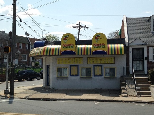
574 S 69Th St
16-03-02136-00
1 STY STORE 27 X 68 X IRR
Restaurantbuilding
Delaware
AE The base floodplain where base flood elevations are provided. AE Zones are now used on new format FIRMs instead of A1-A30 Zones.
Pennsylvania
2024
0.03 AC
2025
Delaware County
400301
Philadelphia
1,371 SF
Philadelphia-Camden-Wilmington, PA-NJ-DE-MD
NEARBY LISTINGS FOR SALE OR LEASE
DEMOGRAPHICS near 574 S 69Th St
1 mile
3 mile
5 mile
2025 Total Population
54,306
376,036
781,991
2030 Population
54,244
376,022
785,577
Pop Growth 2025-2030
(0.11%)
0.00%
+ 0.46%
Average Age
38
38
39
2025 Total Households
19,619
145,973
323,833
HH Growth 2025-2030
(0.18%)
(0.12%)
+ 0.29%
Median Household Inc
$44,061
$52,775
$67,451
Avg Household Size
2.60
2.40
2.30
2025 Avg HH Vehicles
1.00
1.00
1.00
Median Home Value
$157,374
$186,363
$279,724
Median Year Built
1946
1947
1949
Nearby Places
Map Layers
Map Styles
 Street
 Aerial
Transit
 Traffic
 Biking
Places
Listings with unknown addresses are not visible on the map
- Restaurants
- Banks
- Shops
- Fitness
- Groceries
PUBLIC TRANSPORTATION
TRANSIT/SUBWAY
Fernwood-Yeadon (R3 - Southeastern Pennsylvania Transportation Authority Regional Rail (SEPTA Regional Rail))
Drive
Walk
Distance
Fernwood-Yeadon (R3 - Southeastern Pennsylvania Transportation Authority Regional Rail (SEPTA Regional Rail))
5 min
16 min
0.8 mi
Angora Loop (Route 34 - Southeastern Pennsylvania Transportation Authority Rapid Transit (SEPTA Subway & Trolley))
Drive
Walk
Distance
Angora Loop (Route 34 - Southeastern Pennsylvania Transportation Authority Rapid Transit (SEPTA Subway & Trolley))
5 min
19 min
1.0 mi
COMMUTER RAIL
Fernwood-Yeadon (R3 - Southeastern Pennsylvania Transportation Authority Regional Rail (SEPTA Regional Rail))
Drive
Walk
Distance
Fernwood-Yeadon (R3 - Southeastern Pennsylvania Transportation Authority Regional Rail (SEPTA Regional Rail))
5 min
16 min
0.8 mi
Lansdowne (R3 - Southeastern Pennsylvania Transportation Authority Regional Rail (SEPTA Regional Rail))
Drive
Walk
Distance
Lansdowne (R3 - Southeastern Pennsylvania Transportation Authority Regional Rail (SEPTA Regional Rail))
7 min
2.0 mi
AIRPORT
Philadelphia International
Drive
Walk
Distance
Philadelphia International
20 min
7.5 mi
Trenton Mercer
Drive
Walk
Distance
Trenton Mercer
64 min
39.8 mi
Freight Ports
South Jersey Port
Drive
Walk
Distance
South Jersey Port
24 min
10.3 mi
SALE & LEASE HISTORY
LISTING DATE
SALE/LEASE

Jan 21, 2020
For Sale
Nearby Properties
Address
Land Use
TOTAL SIZE
Lot Size
Zoning
Address
Land Use
TOTAL SIZE
Lot Size
Zoning
26,690 SF
500 AC
SPINS
Address
Land Use
TOTAL SIZE
Lot Size
Zoning
696,920 SF
10.55 AC
SPINS
Address
Land Use
TOTAL SIZE
Lot Size
Zoning
385,000 SF
2.49 AC
SPINS
Address
Land Use
TOTAL SIZE
Lot Size
Zoning
375,500 SF
1.40 AC
CMX5
Address
Land Use
TOTAL SIZE
Lot Size
Zoning
303,750 SF
1.36 AC
SPINS
Address
Land Use
TOTAL SIZE
Lot Size
Zoning
239,760 SF
5.51 AC
SPINS
Address
Land Use
TOTAL SIZE
Lot Size
Zoning
2,178,860 SF
48.65 AC
R3
Address
Land Use
TOTAL SIZE
Lot Size
Zoning
Address
Land Use
TOTAL SIZE
Lot Size
Zoning
158,496 SF
Address
Land Use
TOTAL SIZE
Lot Size
Zoning
269,171 SF
2.64 AC
SPINS
Address
Land Use
TOTAL SIZE
Lot Size
Zoning
Address
Land Use
TOTAL SIZE
Lot Size
Zoning
251,000 SF
0.78 AC
SPINS
Address
Land Use
TOTAL SIZE
Lot Size
Zoning
175,069 SF
2.20 AC
CMX3
Address
Land Use
TOTAL SIZE
Lot Size
Zoning
206,365 SF
3.40 AC
RSA5
Address
Land Use
TOTAL SIZE
Lot Size
Zoning
473,841 SF
CMX4
Address
Land Use
TOTAL SIZE
Lot Size
Zoning
304,552 SF
1 AC
SPINS
Address
Land Use
TOTAL SIZE
Lot Size
Zoning
76,614 SF
1.53 AC
CMX3
Address
Land Use
TOTAL SIZE
Lot Size
Zoning
175,000 SF
0.90 AC
SPINS
Address
Land Use
TOTAL SIZE
Lot Size
Zoning
1,600 SF
177.07 AC
SPPOA
Address
Land Use
TOTAL SIZE
Lot Size
Zoning
165,000 SF
0.91 AC
SPINS
Address
Land Use
TOTAL SIZE
Lot Size
Zoning
156,275 SF
0.30 AC
SPINS
Address
Land Use
TOTAL SIZE
Lot Size
Zoning
154,555 SF
1.42 AC
SPINS
Address
Land Use
TOTAL SIZE
Lot Size
Zoning
232,225 SF
0.86 AC
CMX4
Address
Land Use
TOTAL SIZE
Lot Size
Zoning
511,806 SF
1.70 AC
RM4
Address
Land Use
TOTAL SIZE
Lot Size
Zoning
461,834 SF
4.73 AC
CMX3
Address
Land Use
TOTAL SIZE
Lot Size
Zoning
304,000 SF
1.58 AC
CMX4
Address
Land Use
TOTAL SIZE
Lot Size
Zoning
374,105 SF
5.63 AC
CMX3
Address
Land Use
TOTAL SIZE
Lot Size
Zoning
250,500 SF
0.99 AC
CMX5
Address
Land Use
TOTAL SIZE
Lot Size
Zoning
448,864 SF
32.89 AC
Address
Land Use
TOTAL SIZE
Lot Size
Zoning
500,004 SF
1.92 AC
CMX5
The World's #1 Commercial Real Estate Marketplace
Connect with us
© 2026 CoStar Group
The information above has been obtained from sources believed reliable. While we do not doubt its accuracy we have not verified it and make no guarantee, warranty or representation about it. It is your responsibility to independently confirm its accuracy and completeness. Any projections, opinions, assumptions, or estimates used are for example only and do not represent the current or future performance of the property. The value of this transaction to you depends on tax and other factors which should be evaluated by your tax, financial, and legal advisors. You and your advisors should conduct a careful, independent investigation of the property to determine to your satisfaction the suitability of the property for your needs.