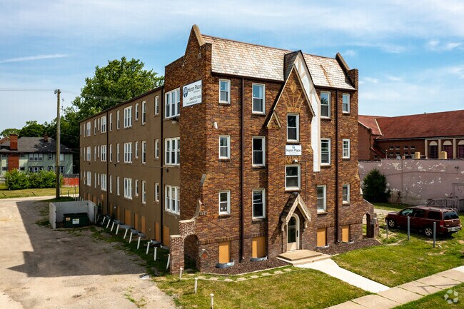
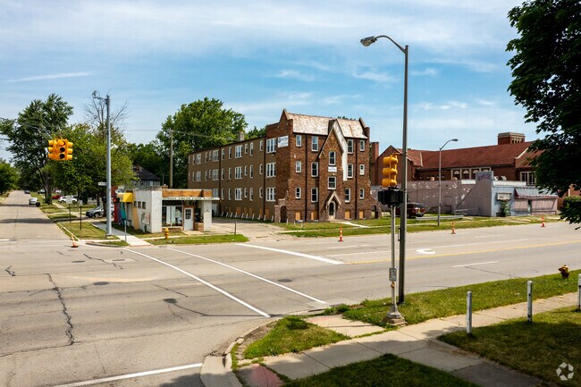
Property Record
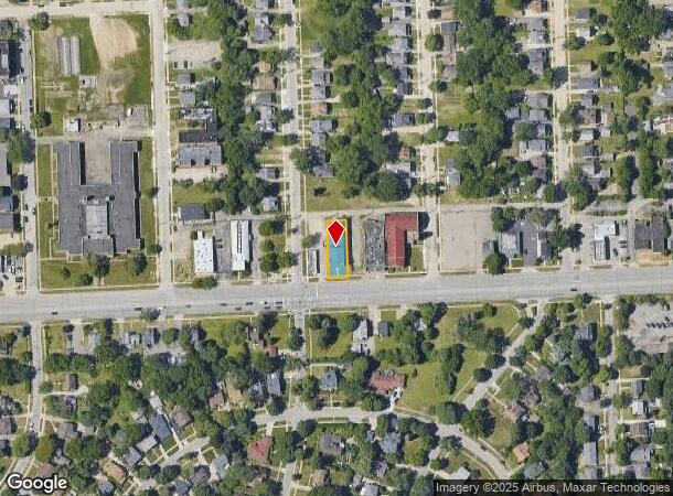
574 W Huron St, Pontiac, MI 48341
NEARBY LISTINGS FOR SALE OR LEASE
Property Detail
574 W Huron St
Detroit-Warren-Dearborn, MI
Grand View Sub
14-30-476-045
T3N, R10E, SEC 30 GRAND VIEW SUB LOT 11
Multifamilydwelling
Oakland
X
Michigan
26125C0364F
11
2024
0.17 AC
2024
Pontiac
142000
Detroit
13,342 SF
DEMOGRAPHICS near 574 W Huron St
1 Mile
3 Mile
5 Mile
2024 Total Population
11,864
79,409
161,802
2029 Population
11,924
79,345
161,168
Pop Growth 2024-2029
+ 0.51%
(0.08%)
(0.39%)
Average Age
39
39
41
2024 Total Households
4,776
32,984
66,896
HH Growth 2024-2029
+ 0.44%
(0.12%)
(0.44%)
Median Household Inc
$47,491
$46,888
$61,210
Avg Household Size
2.30
2.30
2.30
2024 Avg HH Vehicles
2.00
2.00
2.00
Median Home Value
$127,794
$147,713
$219,357
Median Year Built
1949
1961
1968
Nearby Places
Map Layers
Map Styles
 Street
 Aerial
- Restaurants
- Banks
- Shops
- Fitness
- Groceries
PUBLIC TRANSPORTATION
AIRPORT
Bishop International
DRIVE
WALK
Distance
Bishop International
60 min
36.8 mi
Detroit Metro Wayne County
DRIVE
WALK
Distance
Detroit Metro Wayne County
62 min
39.9 mi
Windsor International
DRIVE
WALK
Distance
Windsor International
62 min
40.8 mi
SALE & LEASE HISTORY
LISTING DATE
SALE/LEASE

Oct 19, 2016
For Sale
May 31, 2017
For Sale
Jun 11, 2020
For Sale
Apr 18, 2019
For Sale
Nearby Properties
Address
Land Use
TOTAL SIZE
Lot Size
Zoning
Address
Land Use
TOTAL SIZE
Lot Size
Zoning
526,398 SF
32.99 AC
Address
Land Use
TOTAL SIZE
Lot Size
Zoning
1,771,589 SF
96.73 AC
Address
Land Use
TOTAL SIZE
Lot Size
Zoning
608,251 SF
50.49 AC
II
Address
Land Use
TOTAL SIZE
Lot Size
Zoning
481,186 SF
42.14 AC
AI
Address
Land Use
TOTAL SIZE
Lot Size
Zoning
374,400 SF
4.10 AC
Address
Land Use
TOTAL SIZE
Lot Size
Zoning
426,034 SF
24.99 AC
AI
Address
Land Use
TOTAL SIZE
Lot Size
Zoning
221,340 SF
26.88 AC
Address
Land Use
TOTAL SIZE
Lot Size
Zoning
156,668 SF
13.19 AC
BI
Address
Land Use
TOTAL SIZE
Lot Size
Zoning
23.28 AC
AI
Address
Land Use
TOTAL SIZE
Lot Size
Zoning
97,172 SF
13.82 AC
BI
Address
Land Use
TOTAL SIZE
Lot Size
Zoning
101,320 SF
28.20 AC
Address
Land Use
TOTAL SIZE
Lot Size
Zoning
79,263 SF
22.27 AC
Address
Land Use
TOTAL SIZE
Lot Size
Zoning
145,712 SF
10.51 AC
BV
Address
Land Use
TOTAL SIZE
Lot Size
Zoning
87,560 SF
7.94 AC
BI
Address
Land Use
TOTAL SIZE
Lot Size
Zoning
288,124 SF
15.76 AC
Address
Land Use
TOTAL SIZE
Lot Size
Zoning
1,870,974 SF
61.73 AC
Address
Land Use
TOTAL SIZE
Lot Size
Zoning
93,706 SF
1.13 AC
Address
Land Use
TOTAL SIZE
Lot Size
Zoning
55,912 SF
1.11 AC
Address
Land Use
TOTAL SIZE
Lot Size
Zoning
143,701 SF
9.85 AC
AI
Address
Land Use
TOTAL SIZE
Lot Size
Zoning
562,472 SF
39.69 AC
Address
Land Use
TOTAL SIZE
Lot Size
Zoning
131,214 SF
10.75 AC
AI
Address
Land Use
TOTAL SIZE
Lot Size
Zoning
146,736 SF
14.81 AC
AI
Address
Land Use
TOTAL SIZE
Lot Size
Zoning
96,587 SF
5 AC
BI
Address
Land Use
TOTAL SIZE
Lot Size
Zoning
137,256 SF
14.97 AC
BI
Address
Land Use
TOTAL SIZE
Lot Size
Zoning
64,053 SF
2.69 AC
Address
Land Use
TOTAL SIZE
Lot Size
Zoning
88,110 SF
3.15 AC
AI
Address
Land Use
TOTAL SIZE
Lot Size
Zoning
1,332,530 SF
95.81 AC
Address
Land Use
TOTAL SIZE
Lot Size
Zoning
211,861 SF
2.69 AC
BI
Address
Land Use
TOTAL SIZE
Lot Size
Zoning
55,269 SF
5.40 AC
BI
Address
Land Use
TOTAL SIZE
Lot Size
Zoning
80,600 SF
51.48 AC
The World's #1 Commercial Real Estate Marketplace
Connect with us
© 2025 CoStar Group
The information above has been obtained from sources believed reliable. While we do not doubt its accuracy we have not verified it and make no guarantee, warranty or representation about it. It is your responsibility to independently confirm its accuracy and completeness. Any projections, opinions, assumptions, or estimates used are for example only and do not represent the current or future performance of the property. The value of this transaction to you depends on tax and other factors which should be evaluated by your tax, financial, and legal advisors. You and your advisors should conduct a careful, independent investigation of the property to determine to your satisfaction the suitability of the property for your needs.