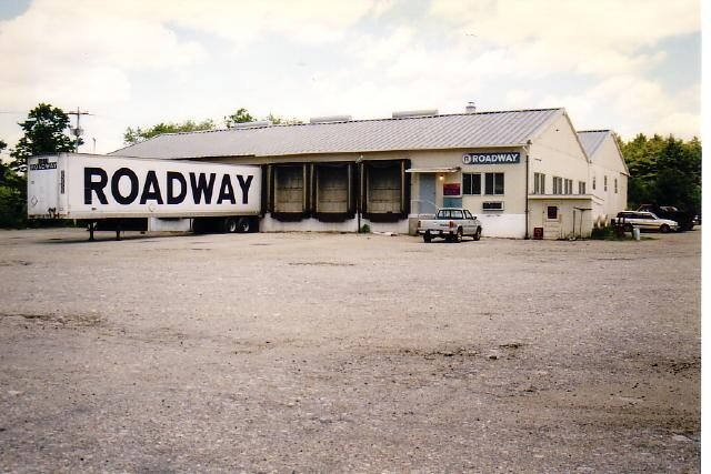
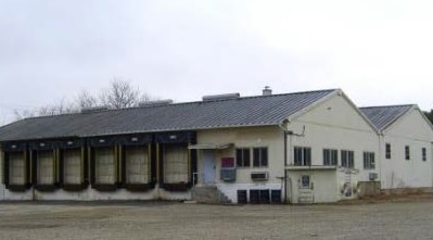
Property Record
574 Westcott Rd, Danielson, CT 06239

Property Detail
574 Westcott Rd
KILL-000214-000000-000007
WINDHAM
Commercialnec
Connecticut
GC
12.95 AC
B and X Area of moderate flood hazard, usually the area between the limits of the 100-year and 500-year floods.
Windham County
2025
Hartford
2025
Willimantic, CT
904102
NEARBY LISTINGS FOR SALE OR LEASE
DEMOGRAPHICS near 574 Westcott Rd
1 mile
3 mile
5 mile
2025 Total Population
936
13,347
25,316
2030 Population
958
13,737
25,975
Pop Growth 2025-2030
+ 2.35%
+ 2.92%
+ 2.60%
Average Age
45
43
43
2025 Total Households
380
5,629
10,233
HH Growth 2025-2030
+ 2.63%
+ 3.04%
+ 2.72%
Median Household Inc
$119,813
$78,654
$87,233
Avg Household Size
2.50
2.30
2.40
2025 Avg HH Vehicles
2.00
2.00
2.00
Median Home Value
$318,182
$282,817
$297,148
Median Year Built
1979
1963
1970
Nearby Places
Map Layers
Map Styles
 Street
 Aerial
Transit
 Traffic
 Biking
Places
Listings with unknown addresses are not visible on the map
- Restaurants
- Banks
- Shops
- Fitness
- Groceries
PUBLIC TRANSPORTATION
AIRPORT
Rhode Island Tf Green International
Drive
Walk
Distance
Rhode Island Tf Green International
41 min
29.9 mi
Freight Ports
Port of Davisville, RI
Drive
Walk
Distance
Port of Davisville, RI
52 min
39.1 mi
SALE & LEASE HISTORY
LISTING DATE
SALE/LEASE

Sep 24, 2016
For Sale
Nearby Properties
Address
Land Use
TOTAL SIZE
Lot Size
Zoning
Address
Land Use
TOTAL SIZE
Lot Size
Zoning
203,150 SF
21 AC
LD
Address
Land Use
TOTAL SIZE
Lot Size
Zoning
22 AC
I
Address
Land Use
TOTAL SIZE
Lot Size
Zoning
53,306 SF
1.60 AC
BI
Address
Land Use
TOTAL SIZE
Lot Size
Zoning
148,118 SF
17 AC
BRHD
Address
Land Use
TOTAL SIZE
Lot Size
Zoning
59,552 SF
4.28 AC
GC
Address
Land Use
TOTAL SIZE
Lot Size
Zoning
50,707 SF
10.50 AC
BRHD
Address
Land Use
TOTAL SIZE
Lot Size
Zoning
67,994 SF
8.30 AC
GC
Address
Land Use
TOTAL SIZE
Lot Size
Zoning
9.77 AC
PC
Address
Land Use
TOTAL SIZE
Lot Size
Zoning
45,960 SF
1.40 AC
MD
Address
Land Use
TOTAL SIZE
Lot Size
Zoning
19.85 AC
R30
Address
Land Use
TOTAL SIZE
Lot Size
Zoning
12.20 AC
MD
Address
Land Use
TOTAL SIZE
Lot Size
Zoning
18,958 SF
1.52 AC
BGC
Address
Land Use
TOTAL SIZE
Lot Size
Zoning
9.12 AC
R10
Address
Land Use
TOTAL SIZE
Lot Size
Zoning
13,472 SF
1.40 AC
PC
Address
Land Use
TOTAL SIZE
Lot Size
Zoning
14,524 SF
0.92 AC
RHD
Address
Land Use
TOTAL SIZE
Lot Size
Zoning
6,250 SF
225 AC
RD
Address
Land Use
TOTAL SIZE
Lot Size
Zoning
4.60 AC
BRHD
Address
Land Use
TOTAL SIZE
Lot Size
Zoning
33,486 SF
4.10 AC
MMUDD
Address
Land Use
TOTAL SIZE
Lot Size
Zoning
28,678 SF
0.95 AC
BRHD
Address
Land Use
TOTAL SIZE
Lot Size
Zoning
4.80 AC
RHD
Address
Land Use
TOTAL SIZE
Lot Size
Zoning
Address
Land Use
TOTAL SIZE
Lot Size
Zoning
2.83 AC
GC
Address
Land Use
TOTAL SIZE
Lot Size
Zoning
25,942 SF
3.52 AC
R10
Address
Land Use
TOTAL SIZE
Lot Size
Zoning
7,116 SF
2.10 AC
BGC
Address
Land Use
TOTAL SIZE
Lot Size
Zoning
12.57 AC
MD
Address
Land Use
TOTAL SIZE
Lot Size
Zoning
4.75 AC
PBO
Address
Land Use
TOTAL SIZE
Lot Size
Zoning
23,584 SF
1.60 AC
BGC
Address
Land Use
TOTAL SIZE
Lot Size
Zoning
Address
Land Use
TOTAL SIZE
Lot Size
Zoning
105 AC
RD
Address
Land Use
TOTAL SIZE
Lot Size
Zoning
23,075 SF
3.88 AC
GC
The World's #1 Commercial Real Estate Marketplace
Connect with us
© 2026 CoStar Group
The information above has been obtained from sources believed reliable. While we do not doubt its accuracy we have not verified it and make no guarantee, warranty or representation about it. It is your responsibility to independently confirm its accuracy and completeness. Any projections, opinions, assumptions, or estimates used are for example only and do not represent the current or future performance of the property. The value of this transaction to you depends on tax and other factors which should be evaluated by your tax, financial, and legal advisors. You and your advisors should conduct a careful, independent investigation of the property to determine to your satisfaction the suitability of the property for your needs.