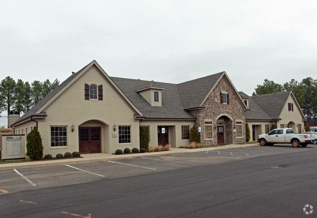
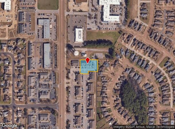
Property Record
5740 Getwell Rd, Southaven, MS 38672

NEARBY LISTINGS FOR SALE OR LEASE
Property Detail
5740 Getwell Rd
Memphis, TN-MS-AR
Snowden Grove Area 17
2072031400000200
SNOWDEN GROVE PUD AREA 17-OFFI LOT 2
Officebuilding
DeSoto
X
Mississippi
28033C0083H
2
2025
0.63 AC
2025
DeSoto County
070631
Memphis
6,572 SF
DEMOGRAPHICS near 5740 Getwell Rd
1 Mile
3 Mile
5 Mile
2024 Total Population
4,799
34,018
76,996
2029 Population
5,292
37,410
84,516
Pop Growth 2024-2029
+ 10.27%
+ 9.97%
+ 9.77%
Average Age
39
39
39
2024 Total Households
1,618
12,187
28,764
HH Growth 2024-2029
+ 10.26%
+ 9.92%
+ 9.83%
Median Household Inc
$107,592
$90,596
$72,665
Avg Household Size
2.90
2.80
2.60
2024 Avg HH Vehicles
2.00
2.00
2.00
Median Home Value
$262,056
$254,426
$243,470
Median Year Built
2005
2003
1998
Nearby Places
Map Layers
Map Styles
 Street
 Aerial
- Restaurants
- Banks
- Shops
- Fitness
- Groceries
PUBLIC TRANSPORTATION
AIRPORT
Memphis International
DRIVE
WALK
Distance
Memphis International
19 min
11.6 mi
SALE & LEASE HISTORY
LISTING DATE
SALE/LEASE

Jun 22, 2018
For Sale
Nearby Properties
Address
Land Use
TOTAL SIZE
Lot Size
Zoning
Address
Land Use
TOTAL SIZE
Lot Size
Zoning
454,272 SF
22.28 AC
PBP
Address
Land Use
TOTAL SIZE
Lot Size
Zoning
5,189 SF
9.62 AC
C-4
Address
Land Use
TOTAL SIZE
Lot Size
Zoning
13,129 SF
12 AC
PUD
Address
Land Use
TOTAL SIZE
Lot Size
Zoning
5,384 SF
7.92 AC
PUD
Address
Land Use
TOTAL SIZE
Lot Size
Zoning
64,571 SF
11.09 AC
C-4
Address
Land Use
TOTAL SIZE
Lot Size
Zoning
30,223 SF
12.41 AC
C-4
Address
Land Use
TOTAL SIZE
Lot Size
Zoning
127,150 SF
11.17 AC
C-4
Address
Land Use
TOTAL SIZE
Lot Size
Zoning
83,020 SF
13.19 AC
C-4
Address
Land Use
TOTAL SIZE
Lot Size
Zoning
135,662 SF
15.30 AC
C-4
Address
Land Use
TOTAL SIZE
Lot Size
Zoning
88,766 SF
12.20 AC
PUD
Address
Land Use
TOTAL SIZE
Lot Size
Zoning
101,248 SF
9.47 AC
C-4
Address
Land Use
TOTAL SIZE
Lot Size
Zoning
105,260 SF
11.62 AC
C-4
Address
Land Use
TOTAL SIZE
Lot Size
Zoning
19,576 SF
2.65 AC
PUD
Address
Land Use
TOTAL SIZE
Lot Size
Zoning
34,542 SF
8.41 AC
C-4
Address
Land Use
TOTAL SIZE
Lot Size
Zoning
59,864 SF
6.10 AC
R-3
Address
Land Use
TOTAL SIZE
Lot Size
Zoning
61,948 SF
4.37 AC
PUD
Address
Land Use
TOTAL SIZE
Lot Size
Zoning
67,166 SF
3.19 AC
C-4
Address
Land Use
TOTAL SIZE
Lot Size
Zoning
24,558 SF
8.39 AC
C-3
Address
Land Use
TOTAL SIZE
Lot Size
Zoning
15,143 SF
12.59 AC
A
Address
Land Use
TOTAL SIZE
Lot Size
Zoning
41,935 SF
7.77 AC
C-4
Address
Land Use
TOTAL SIZE
Lot Size
Zoning
43,863 SF
7.68 AC
C-4
Address
Land Use
TOTAL SIZE
Lot Size
Zoning
61,429 SF
4.18 AC
PUD
Address
Land Use
TOTAL SIZE
Lot Size
Zoning
28,520 SF
10.01 AC
C-4
Address
Land Use
TOTAL SIZE
Lot Size
Zoning
47,722 SF
2.36 AC
PUD
Address
Land Use
TOTAL SIZE
Lot Size
Zoning
36,193 SF
4.55 AC
C-4
Address
Land Use
TOTAL SIZE
Lot Size
Zoning
25,447 SF
7.02 AC
C-3
Address
Land Use
TOTAL SIZE
Lot Size
Zoning
35,037 SF
5.14 AC
C-4
Address
Land Use
TOTAL SIZE
Lot Size
Zoning
39,121 SF
3.78 AC
C-4
Address
Land Use
TOTAL SIZE
Lot Size
Zoning
30,295 SF
7.26 AC
C-4
Address
Land Use
TOTAL SIZE
Lot Size
Zoning
31,513 SF
2.15 AC
PUD
The World's #1 Commercial Real Estate Marketplace
Connect with us
© 2026 CoStar Group
The information above has been obtained from sources believed reliable. While we do not doubt its accuracy we have not verified it and make no guarantee, warranty or representation about it. It is your responsibility to independently confirm its accuracy and completeness. Any projections, opinions, assumptions, or estimates used are for example only and do not represent the current or future performance of the property. The value of this transaction to you depends on tax and other factors which should be evaluated by your tax, financial, and legal advisors. You and your advisors should conduct a careful, independent investigation of the property to determine to your satisfaction the suitability of the property for your needs.