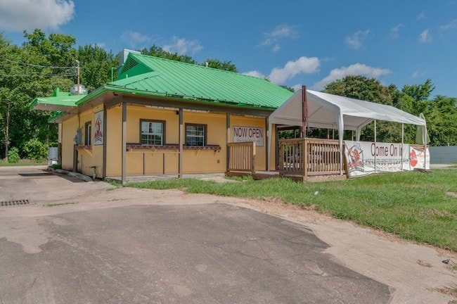
Property Record
5740 S Wayside Dr, Houston, TX 77087

Property Detail
5740 S Wayside Dr
Houston-Pasadena-The Woodlands, TX
LT 16 & TRS 13 14 & 15 BLK 41 KINGS COURT
0591350410007
HARRIS
Restaurantdrivein
Texas
B and X Area of moderate flood hazard, usually the area between the limits of the 100-year and 500-year floods.
16
2024
0.39 AC
2025
Near South
332700
Houston
1,122 SF
NEARBY LISTINGS FOR SALE OR LEASE
DEMOGRAPHICS near 5740 S Wayside Dr
1 mile
3 mile
5 mile
2024 Total Population
13,891
145,937
353,978
2029 Population
15,105
156,562
381,180
Pop Growth 2024-2029
+ 8.74%
+ 7.28%
+ 7.68%
Average Age
37
37
37
2024 Total Households
4,691
49,920
129,642
HH Growth 2024-2029
+ 9.96%
+ 7.65%
+ 8.16%
Median Household Inc
$39,606
$45,963
$51,562
Avg Household Size
2.90
2.80
2.60
2024 Avg HH Vehicles
2.00
2.00
2.00
Median Home Value
$138,312
$189,483
$221,153
Median Year Built
1966
1963
1970
Nearby Places
Map Layers
Map Styles
 Street
 Aerial
Transit
 Traffic
 Biking
Places
Listings with unknown addresses are not visible on the map
- Restaurants
- Banks
- Shops
- Fitness
- Groceries
SALE & LEASE HISTORY
LISTING DATE
SALE/LEASE

Sep 25, 2016
For Lease
Nov 06, 2025
For Lease
May 28, 2019
For Lease
Dec 05, 2018
For Lease
Nearby Properties
Address
Land Use
TOTAL SIZE
Lot Size
Zoning
Address
Land Use
TOTAL SIZE
Lot Size
Zoning
453,987 SF
4.33 AC
Address
Land Use
TOTAL SIZE
Lot Size
Zoning
403,242 SF
46.18 AC
Address
Land Use
TOTAL SIZE
Lot Size
Zoning
1,171,276 SF
44.19 AC
Address
Land Use
TOTAL SIZE
Lot Size
Zoning
159,235 SF
1.49 AC
Address
Land Use
TOTAL SIZE
Lot Size
Zoning
310,171 SF
2.35 AC
Address
Land Use
TOTAL SIZE
Lot Size
Zoning
389,108 SF
37.39 AC
Address
Land Use
TOTAL SIZE
Lot Size
Zoning
198,023 SF
17.87 AC
Address
Land Use
TOTAL SIZE
Lot Size
Zoning
504,018 SF
37.16 AC
Address
Land Use
TOTAL SIZE
Lot Size
Zoning
419,760 SF
15.27 AC
Address
Land Use
TOTAL SIZE
Lot Size
Zoning
556,568 SF
20 AC
Address
Land Use
TOTAL SIZE
Lot Size
Zoning
232,915 SF
7.89 AC
Address
Land Use
TOTAL SIZE
Lot Size
Zoning
228,886 SF
1.85 AC
Address
Land Use
TOTAL SIZE
Lot Size
Zoning
267,844 SF
10.98 AC
Address
Land Use
TOTAL SIZE
Lot Size
Zoning
194,296 SF
15.13 AC
Address
Land Use
TOTAL SIZE
Lot Size
Zoning
196,000 SF
29.42 AC
Address
Land Use
TOTAL SIZE
Lot Size
Zoning
239,458 SF
15.57 AC
Address
Land Use
TOTAL SIZE
Lot Size
Zoning
210,476 SF
9.60 AC
Address
Land Use
TOTAL SIZE
Lot Size
Zoning
284,290 SF
20 AC
Address
Land Use
TOTAL SIZE
Lot Size
Zoning
433,760 SF
52.70 AC
Address
Land Use
TOTAL SIZE
Lot Size
Zoning
113,688 SF
4 AC
Address
Land Use
TOTAL SIZE
Lot Size
Zoning
257,481 SF
9.28 AC
Address
Land Use
TOTAL SIZE
Lot Size
Zoning
244,134 SF
9.44 AC
Address
Land Use
TOTAL SIZE
Lot Size
Zoning
100,458 SF
8.54 AC
Address
Land Use
TOTAL SIZE
Lot Size
Zoning
54,077 SF
5.06 AC
Address
Land Use
TOTAL SIZE
Lot Size
Zoning
44,327 SF
5.40 AC
Address
Land Use
TOTAL SIZE
Lot Size
Zoning
126,000 SF
1.51 AC
Address
Land Use
TOTAL SIZE
Lot Size
Zoning
445,535 SF
36.94 AC
Address
Land Use
TOTAL SIZE
Lot Size
Zoning
241,219 SF
8.92 AC
Address
Land Use
TOTAL SIZE
Lot Size
Zoning
177,406 SF
10.86 AC
Address
Land Use
TOTAL SIZE
Lot Size
Zoning
222,896 SF
10.79 AC
The World's #1 Commercial Real Estate Marketplace
Connect with us
© 2026 CoStar Group
The information above has been obtained from sources believed reliable. While we do not doubt its accuracy we have not verified it and make no guarantee, warranty or representation about it. It is your responsibility to independently confirm its accuracy and completeness. Any projections, opinions, assumptions, or estimates used are for example only and do not represent the current or future performance of the property. The value of this transaction to you depends on tax and other factors which should be evaluated by your tax, financial, and legal advisors. You and your advisors should conduct a careful, independent investigation of the property to determine to your satisfaction the suitability of the property for your needs.