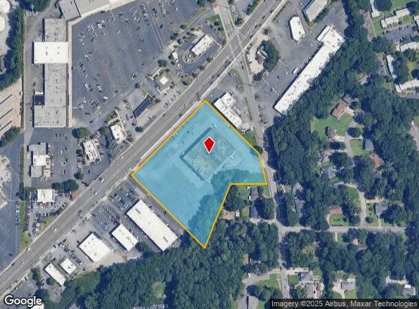
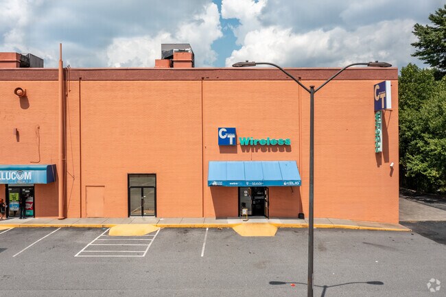
Property Record
5745 Buford Hwy Ne, Atlanta, GA 30340


Current Lease Availabilities
NEARBY LISTINGS FOR SALE OR LEASE
Property Detail
5745 Buford Hwy Ne
18-320-01-026
01/15/2015
Storebuilding
DeKalb
X
Georgia
13089C0017K
26
2025
4.59 AC
2025
Norcross/Peachtree
021309
Atlanta
61,408 SF
Atlanta-Sandy Springs-Roswell, GA
DEMOGRAPHICS near 5745 Buford Hwy Ne
1 Mile
3 Mile
5 Mile
2024 Total Population
9,332
99,360
272,126
2029 Population
9,297
100,090
274,911
Pop Growth 2024-2029
(0.38%)
+ 0.73%
+ 1.02%
Average Age
35
35
37
2024 Total Households
3,039
39,401
107,850
HH Growth 2024-2029
(0.26%)
+ 0.77%
+ 0.93%
Median Household Inc
$47,827
$58,117
$74,053
Avg Household Size
3.00
2.50
2.50
2024 Avg HH Vehicles
2.00
2.00
2.00
Median Home Value
$280,584
$338,162
$406,132
Median Year Built
1974
1980
1984
Nearby Places
- Restaurants
- Banks
- Shops
- Fitness
- Groceries
PUBLIC TRANSPORTATION
TRANSIT/SUBWAY
Doraville (Gold Line - Metropolitan Atlanta Rapid Transit Authority (MARTA))
DRIVE
WALK
Distance
Doraville (Gold Line - Metropolitan Atlanta Rapid Transit Authority (MARTA))
3 min
19 min
1.0 mi
AIRPORT
Hartsfield - Jackson Atlanta International
DRIVE
WALK
Distance
Hartsfield - Jackson Atlanta International
36 min
24.9 mi
Freight Ports
Georgia Ports - Savannah
DRIVE
WALK
Distance
Georgia Ports - Savannah
292 min
260.1 mi
Nearby Properties
Address
Land Use
TOTAL SIZE
Lot Size
Zoning
Address
Land Use
TOTAL SIZE
Lot Size
Zoning
705,518 SF
39.09 AC
M
Address
Land Use
TOTAL SIZE
Lot Size
Zoning
299,993 SF
4.72 AC
I1
Address
Land Use
TOTAL SIZE
Lot Size
Zoning
602,924 SF
75.93 AC
RM100
Address
Land Use
TOTAL SIZE
Lot Size
Zoning
432,424 SF
3.87 AC
MC
Address
Land Use
TOTAL SIZE
Lot Size
Zoning
276,504 SF
3.40 AC
C1
Address
Land Use
TOTAL SIZE
Lot Size
Zoning
103,056 SF
8.66 AC
OI
Address
Land Use
TOTAL SIZE
Lot Size
Zoning
349,619 SF
24.50 AC
RM75
Address
Land Use
TOTAL SIZE
Lot Size
Zoning
524,000 SF
44.93 AC
RM
Address
Land Use
TOTAL SIZE
Lot Size
Zoning
157,133 SF
5.03 AC
M
Address
Land Use
TOTAL SIZE
Lot Size
Zoning
283,784 SF
30.88 AC
RM100
Address
Land Use
TOTAL SIZE
Lot Size
Zoning
204,376 SF
14.23 AC
X
Address
Land Use
TOTAL SIZE
Lot Size
Zoning
366,276 SF
11.54 AC
RM-HD
Address
Land Use
TOTAL SIZE
Lot Size
Zoning
317,595 SF
25.50 AC
RM75
Address
Land Use
TOTAL SIZE
Lot Size
Zoning
214,915 SF
3.55 AC
Address
Land Use
TOTAL SIZE
Lot Size
Zoning
358,622 SF
31.01 AC
RM13
Address
Land Use
TOTAL SIZE
Lot Size
Zoning
169,476 SF
3 AC
MC
Address
Land Use
TOTAL SIZE
Lot Size
Zoning
536,151 SF
30.35 AC
X
Address
Land Use
TOTAL SIZE
Lot Size
Zoning
179,762 SF
4.96 AC
C1
Address
Land Use
TOTAL SIZE
Lot Size
Zoning
424,948 SF
39.03 AC
RM13
Address
Land Use
TOTAL SIZE
Lot Size
Zoning
503,480 SF
50.04 AC
RM150
Address
Land Use
TOTAL SIZE
Lot Size
Zoning
208,466 SF
20.97 AC
RM
Address
Land Use
TOTAL SIZE
Lot Size
Zoning
230,829 SF
2.74 AC
R1
Address
Land Use
TOTAL SIZE
Lot Size
Zoning
350,038 SF
25.05 AC
X
Address
Land Use
TOTAL SIZE
Lot Size
Zoning
211,544 SF
5.80 AC
RM75
Address
Land Use
TOTAL SIZE
Lot Size
Zoning
297,057 SF
25 AC
X
Address
Land Use
TOTAL SIZE
Lot Size
Zoning
141,164 SF
4.74 AC
Address
Land Use
TOTAL SIZE
Lot Size
Zoning
297,996 SF
2.80 AC
M
Address
Land Use
TOTAL SIZE
Lot Size
Zoning
249,766 SF
25.34 AC
RM100
Address
Land Use
TOTAL SIZE
Lot Size
Zoning
185,066 SF
25.53 AC
O-1
Address
Land Use
TOTAL SIZE
Lot Size
Zoning
229,415 SF
10.41 AC
RM-HD
The World's #1 Commercial Real Estate Marketplace
Connect with us
© 2025 CoStar Group
The information above has been obtained from sources believed reliable. While we do not doubt its accuracy we have not verified it and make no guarantee, warranty or representation about it. It is your responsibility to independently confirm its accuracy and completeness. Any projections, opinions, assumptions, or estimates used are for example only and do not represent the current or future performance of the property. The value of this transaction to you depends on tax and other factors which should be evaluated by your tax, financial, and legal advisors. You and your advisors should conduct a careful, independent investigation of the property to determine to your satisfaction the suitability of the property for your needs.