Property Record
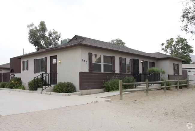
575 6Th St, Norco, CA 92860


Property Detail
575 6Th St
Riverside-San Bernardino-Ontario, CA
.75 ACRES M/L IN POR LOT 16 BLK 41 MB 011/056 NORCO FARMS TR NO 2
133-150-029
Riverside
Officebuilding
California
C2
16
B and X Area of moderate flood hazard, usually the area between the limits of the 100-year and 500-year floods.
0.75 AC
2024
Corona/Eastvale
2025
Inland Empire (California)
040703
NEARBY LISTINGS FOR SALE OR LEASE
DEMOGRAPHICS near 575 6Th St
1 mile
3 mile
5 mile
2025 Total Population
6,219
77,533
303,844
2030 Population
6,280
78,817
310,171
Pop Growth 2025-2030
+ 0.98%
+ 1.66%
+ 2.08%
Average Age
41
38
36
2025 Total Households
1,928
20,136
81,601
HH Growth 2025-2030
+ 0.31%
+ 1.09%
+ 1.68%
Median Household Inc
$129,121
$126,817
$108,354
Avg Household Size
3.10
3.50
3.50
2025 Avg HH Vehicles
3.00
3.00
3.00
Median Home Value
$782,277
$739,546
$700,107
Median Year Built
1969
1991
1989
Nearby Places
Map Layers
Map Styles
 Street
 Aerial
Transit
 Traffic
 Biking
Places
Listings with unknown addresses are not visible on the map
- Restaurants
- Banks
- Shops
- Fitness
- Groceries
PUBLIC TRANSPORTATION
COMMUTER RAIL
North Main Corona (91 Line - Southern California Regional Rail Authority (Metrolink), Inland Empire-Orange County Line - Southern California Regional Rail Authority (Metrolink))
Drive
Walk
Distance
North Main Corona (91 Line - Southern California Regional Rail Authority (Metrolink), Inland Empire-Orange County Line - Southern California Regional Rail Authority (Metrolink))
10 min
5.6 mi
Riverside-La Sierra (91 Line - Southern California Regional Rail Authority (Metrolink), Inland Empire-Orange County Line - Southern California Regional Rail Authority (Metrolink))
Drive
Walk
Distance
Riverside-La Sierra (91 Line - Southern California Regional Rail Authority (Metrolink), Inland Empire-Orange County Line - Southern California Regional Rail Authority (Metrolink))
15 min
7.2 mi
AIRPORT
Ontario International
Drive
Walk
Distance
Ontario International
21 min
11.0 mi
John Wayne/Orange County
Drive
Walk
Distance
John Wayne/Orange County
44 min
34.5 mi
Freight Ports
Port of Long Beach
Drive
Walk
Distance
Port of Long Beach
66 min
48.6 mi
Nearby Properties
Address
Land Use
TOTAL SIZE
Lot Size
Zoning
Address
Land Use
TOTAL SIZE
Lot Size
Zoning
165,463 SF
17.43 AC
Address
Land Use
TOTAL SIZE
Lot Size
Zoning
76,546 SF
13.53 AC
R
Address
Land Use
TOTAL SIZE
Lot Size
Zoning
364,193 SF
23.77 AC
Address
Land Use
TOTAL SIZE
Lot Size
Zoning
46,694 SF
7.16 AC
Address
Land Use
TOTAL SIZE
Lot Size
Zoning
154,581 SF
8.30 AC
Address
Land Use
TOTAL SIZE
Lot Size
Zoning
160,264 SF
9.21 AC
M1
Address
Land Use
TOTAL SIZE
Lot Size
Zoning
145,424 SF
7.23 AC
Address
Land Use
TOTAL SIZE
Lot Size
Zoning
128,674 SF
6.71 AC
M1
Address
Land Use
TOTAL SIZE
Lot Size
Zoning
116,654 SF
6.03 AC
Address
Land Use
TOTAL SIZE
Lot Size
Zoning
96,961 SF
4.95 AC
Address
Land Use
TOTAL SIZE
Lot Size
Zoning
100,122 SF
5.25 AC
Address
Land Use
TOTAL SIZE
Lot Size
Zoning
73,867 SF
4.09 AC
Address
Land Use
TOTAL SIZE
Lot Size
Zoning
88,830 SF
4 AC
Address
Land Use
TOTAL SIZE
Lot Size
Zoning
88,900 SF
7.31 AC
CPS
Address
Land Use
TOTAL SIZE
Lot Size
Zoning
77,787 SF
4.43 AC
Address
Land Use
TOTAL SIZE
Lot Size
Zoning
112,814 SF
6.93 AC
CPS
Address
Land Use
TOTAL SIZE
Lot Size
Zoning
49,397 SF
1.35 AC
CA
Address
Land Use
TOTAL SIZE
Lot Size
Zoning
53,563 SF
1.45 AC
CPS
Address
Land Use
TOTAL SIZE
Lot Size
Zoning
64,631 SF
2.67 AC
Address
Land Use
TOTAL SIZE
Lot Size
Zoning
67,400 SF
2.96 AC
Address
Land Use
TOTAL SIZE
Lot Size
Zoning
68,266 SF
2.33 AC
Address
Land Use
TOTAL SIZE
Lot Size
Zoning
75,237 SF
3.45 AC
Address
Land Use
TOTAL SIZE
Lot Size
Zoning
123,735 SF
9.99 AC
CPS
Address
Land Use
TOTAL SIZE
Lot Size
Zoning
64,800 SF
2.99 AC
Address
Land Use
TOTAL SIZE
Lot Size
Zoning
116,348 SF
2.60 AC
Address
Land Use
TOTAL SIZE
Lot Size
Zoning
57,073 SF
2.52 AC
Address
Land Use
TOTAL SIZE
Lot Size
Zoning
43,375 SF
4.41 AC
Address
Land Use
TOTAL SIZE
Lot Size
Zoning
48,100 SF
2.41 AC
C2
Address
Land Use
TOTAL SIZE
Lot Size
Zoning
30.97 AC
Address
Land Use
TOTAL SIZE
Lot Size
Zoning
56,208 SF
4.88 AC
CPS
The World's #1 Commercial Real Estate Marketplace
Connect with us
© 2026 CoStar Group
The information above has been obtained from sources believed reliable. While we do not doubt its accuracy we have not verified it and make no guarantee, warranty or representation about it. It is your responsibility to independently confirm its accuracy and completeness. Any projections, opinions, assumptions, or estimates used are for example only and do not represent the current or future performance of the property. The value of this transaction to you depends on tax and other factors which should be evaluated by your tax, financial, and legal advisors. You and your advisors should conduct a careful, independent investigation of the property to determine to your satisfaction the suitability of the property for your needs.