Property Record
575 E Lake Mead Pky, Henderson, NV 89015

NEARBY LISTINGS FOR SALE OR LEASE
Property Detail
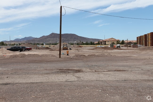
575 E Lake Mead Pky
Las Vegas-Henderson-Paradise, NV
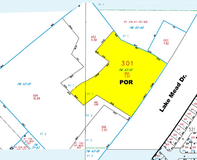
Parcel Map File 116 Page 75
179-08-301-011
PARCEL MAP FILE 116 PAGE 75 LOT 2
Apartment
Clark
X
Nevada
32003C2615F
2
0
4.98 AC
2025
SE Las Vegas/Henderson
005438
Las Vegas
2,989 SF
DEMOGRAPHICS near 575 E Lake Mead Pky
1 Mile
3 Mile
5 Mile
2024 Total Population
17,222
80,140
194,601
2029 Population
18,916
87,053
209,971
Pop Growth 2024-2029
+ 9.84%
+ 8.63%
+ 7.90%
Average Age
38
41
40
2024 Total Households
6,447
30,697
74,317
HH Growth 2024-2029
+ 9.97%
+ 8.68%
+ 7.93%
Median Household Inc
$49,477
$71,460
$74,105
Avg Household Size
2.60
2.50
2.50
2024 Avg HH Vehicles
2.00
2.00
2.00
Median Home Value
$322,671
$369,512
$379,309
Median Year Built
1992
1997
1999
Nearby Places
Map Layers
Map Styles
 Street
 Aerial
- Restaurants
- Banks
- Shops
- Fitness
- Groceries
PUBLIC TRANSPORTATION
AIRPORT
Boulder City Municipal
DRIVE
WALK
Distance
Boulder City Municipal
21 min
11.7 mi
Harry Reid International
DRIVE
WALK
Distance
Harry Reid International
20 min
13.9 mi
Nearby Properties
Address
Land Use
TOTAL SIZE
Lot Size
Zoning
Address
Land Use
TOTAL SIZE
Lot Size
Zoning
62,258 SF
59.95 AC
Address
Land Use
TOTAL SIZE
Lot Size
Zoning
Address
Land Use
TOTAL SIZE
Lot Size
Zoning
31,463 SF
191.46 AC
PS
Address
Land Use
TOTAL SIZE
Lot Size
Zoning
46.75 AC
PS
Address
Land Use
TOTAL SIZE
Lot Size
Zoning
10.50 AC
Address
Land Use
TOTAL SIZE
Lot Size
Zoning
81,485 SF
160.06 AC
PS
Address
Land Use
TOTAL SIZE
Lot Size
Zoning
387,990 SF
22.04 AC
Address
Land Use
TOTAL SIZE
Lot Size
Zoning
1,500 SF
25.08 AC
Address
Land Use
TOTAL SIZE
Lot Size
Zoning
9,493 SF
15.37 AC
Address
Land Use
TOTAL SIZE
Lot Size
Zoning
9,000 SF
96.81 AC
RE
Address
Land Use
TOTAL SIZE
Lot Size
Zoning
4,578 SF
13.23 AC
H:RH-24-MP
Address
Land Use
TOTAL SIZE
Lot Size
Zoning
40,031 SF
21.25 AC
Address
Land Use
TOTAL SIZE
Lot Size
Zoning
239,288 SF
14.10 AC
Address
Land Use
TOTAL SIZE
Lot Size
Zoning
250,076 SF
24.61 AC
Address
Land Use
TOTAL SIZE
Lot Size
Zoning
71,133 SF
7.56 AC
DP
Address
Land Use
TOTAL SIZE
Lot Size
Zoning
295,238 SF
23.49 AC
IP
Address
Land Use
TOTAL SIZE
Lot Size
Zoning
19,753 SF
10.21 AC
DP
Address
Land Use
TOTAL SIZE
Lot Size
Zoning
107,524 SF
45.92 AC
Address
Land Use
TOTAL SIZE
Lot Size
Zoning
23,087 SF
71.36 AC
PS
Address
Land Use
TOTAL SIZE
Lot Size
Zoning
213,472 SF
7.46 AC
Address
Land Use
TOTAL SIZE
Lot Size
Zoning
12,621 SF
19.48 AC
Address
Land Use
TOTAL SIZE
Lot Size
Zoning
3,664 SF
16.09 AC
RH20
Address
Land Use
TOTAL SIZE
Lot Size
Zoning
3,293 SF
17.37 AC
H:RM-16-MP
Address
Land Use
TOTAL SIZE
Lot Size
Zoning
186,000 SF
13.63 AC
H:IG-MP
Address
Land Use
TOTAL SIZE
Lot Size
Zoning
241,207 SF
13.42 AC
IG
Address
Land Use
TOTAL SIZE
Lot Size
Zoning
168,361 SF
10.84 AC
Address
Land Use
TOTAL SIZE
Lot Size
Zoning
358,284 SF
17.44 AC
IG
Address
Land Use
TOTAL SIZE
Lot Size
Zoning
136,465 SF
34.67 AC
Address
Land Use
TOTAL SIZE
Lot Size
Zoning
3,181 SF
16.19 AC
RM16
The World's #1 Commercial Real Estate Marketplace
Connect with us
© 2025 CoStar Group
The information above has been obtained from sources believed reliable. While we do not doubt its accuracy we have not verified it and make no guarantee, warranty or representation about it. It is your responsibility to independently confirm its accuracy and completeness. Any projections, opinions, assumptions, or estimates used are for example only and do not represent the current or future performance of the property. The value of this transaction to you depends on tax and other factors which should be evaluated by your tax, financial, and legal advisors. You and your advisors should conduct a careful, independent investigation of the property to determine to your satisfaction the suitability of the property for your needs.