Property Record
575 Union Bridge Rd, Union Bridge, MD 21791
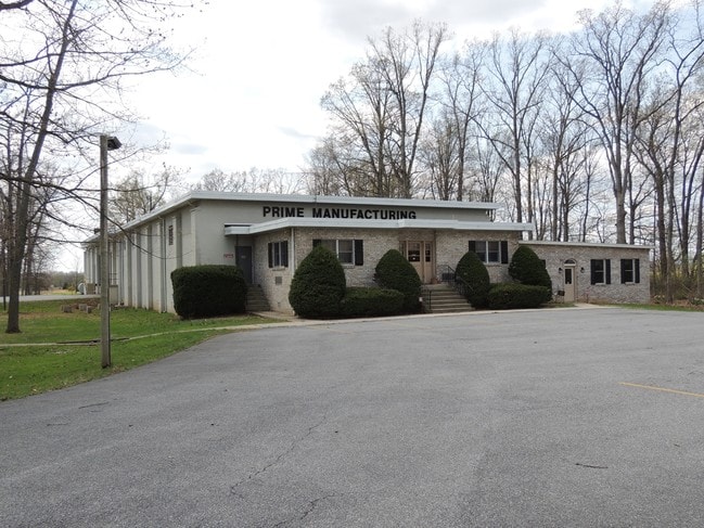

Property Detail
575 Union Bridge Rd
12-003242
LT - 39.69 ACS 575 UNION BRIDGE RD M36-13-351
Warehouse
Carroll
I-1
Maryland
B and X Area of moderate flood hazard, usually the area between the limits of the 100-year and 500-year floods.
39.69 AC
2025
Carroll County
2025
Baltimore
512000
Baltimore-Columbia-Towson, MD
6,260 SF
NEARBY LISTINGS FOR SALE OR LEASE
-
-
View all Union Bridge listings for sale on LoopNet.com
DEMOGRAPHICS near 575 Union Bridge Rd
1 mile
3 mile
5 mile
2025 Total Population
287
3,097
13,238
2030 Population
289
3,144
13,587
Pop Growth 2025-2030
+ 0.70%
+ 1.52%
+ 2.64%
Average Age
42
42
42
2025 Total Households
112
1,180
5,037
HH Growth 2025-2030
+ 0.89%
+ 1.53%
+ 2.68%
Median Household Inc
$79,375
$85,061
$88,785
Avg Household Size
2.60
2.60
2.60
2025 Avg HH Vehicles
2.00
2.00
2.00
Median Home Value
$334,000
$361,554
$358,297
Median Year Built
1947
1949
1975
Nearby Places
Map Layers
Map Styles
 Street
 Aerial
Layers
 Traffic
 Biking
Places
Listings with unknown addresses are not visible on the map
- Restaurants
- Banks
- Shops
- Fitness
- Groceries
SALE & LEASE HISTORY
LISTING DATE
SALE/LEASE

Aug 09, 2018
For Sale
Apr 04, 2017
For Sale
Nearby Properties
Address
Land Use
TOTAL SIZE
Lot Size
Zoning
Address
Land Use
TOTAL SIZE
Lot Size
Zoning
193,354 SF
24.18 AC
CONSE
Address
Land Use
TOTAL SIZE
Lot Size
Zoning
5,184 SF
75.39 AC
AGRIC
Address
Land Use
TOTAL SIZE
Lot Size
Zoning
70,807 SF
17.33 AC
R-100
Address
Land Use
TOTAL SIZE
Lot Size
Zoning
45,602 SF
137.42 AC
I-2
Address
Land Use
TOTAL SIZE
Lot Size
Zoning
11,700 SF
13.50 AC
AGRIC
Address
Land Use
TOTAL SIZE
Lot Size
Zoning
3,514 SF
73.62 AC
AGRIC
Address
Land Use
TOTAL SIZE
Lot Size
Zoning
104.56 AC
R-100
Address
Land Use
TOTAL SIZE
Lot Size
Zoning
19,000 SF
2.50 AC
R-600
Address
Land Use
TOTAL SIZE
Lot Size
Zoning
3,940 SF
94.12 AC
IR
Address
Land Use
TOTAL SIZE
Lot Size
Zoning
110.24 AC
R-100
Address
Land Use
TOTAL SIZE
Lot Size
Zoning
110,590 SF
12 AC
IR
Address
Land Use
TOTAL SIZE
Lot Size
Zoning
18,288 SF
4.70 AC
BG
Address
Land Use
TOTAL SIZE
Lot Size
Zoning
28,966 SF
117.50 AC
MM
Address
Land Use
TOTAL SIZE
Lot Size
Zoning
26,844 SF
145.89 AC
AGRIC
Address
Land Use
TOTAL SIZE
Lot Size
Zoning
7,194 SF
1.84 AC
AGRIC
Address
Land Use
TOTAL SIZE
Lot Size
Zoning
7,734 SF
6.30 AC
IR
Address
Land Use
TOTAL SIZE
Lot Size
Zoning
9,103 SF
8.78 AC
AGRIC
Address
Land Use
TOTAL SIZE
Lot Size
Zoning
5,366 SF
91.54 AC
A
Address
Land Use
TOTAL SIZE
Lot Size
Zoning
1,406 SF
2.37 AC
R-600
Address
Land Use
TOTAL SIZE
Lot Size
Zoning
4,928 SF
125.03 AC
A
Address
Land Use
TOTAL SIZE
Lot Size
Zoning
9,720 SF
3.70 AC
AGRIC
Address
Land Use
TOTAL SIZE
Lot Size
Zoning
4,800 SF
5 AC
AGRIC
Address
Land Use
TOTAL SIZE
Lot Size
Zoning
3,329 SF
26.33 AC
Address
Land Use
TOTAL SIZE
Lot Size
Zoning
3,520 SF
12.94 AC
IR
Address
Land Use
TOTAL SIZE
Lot Size
Zoning
20.65 AC
AGRIC
Address
Land Use
TOTAL SIZE
Lot Size
Zoning
6,200 SF
1.12 AC
BG
Address
Land Use
TOTAL SIZE
Lot Size
Zoning
640 SF
17.57 AC
CONSE
Address
Land Use
TOTAL SIZE
Lot Size
Zoning
2,986 SF
50 AC
A
Address
Land Use
TOTAL SIZE
Lot Size
Zoning
68.33 AC
I-2
The World's #1 Commercial Real Estate Marketplace
Connect with us
© 2026 CoStar Group
The information above has been obtained from sources believed reliable. While we do not doubt its accuracy we have not verified it and make no guarantee, warranty or representation about it. It is your responsibility to independently confirm its accuracy and completeness. Any projections, opinions, assumptions, or estimates used are for example only and do not represent the current or future performance of the property. The value of this transaction to you depends on tax and other factors which should be evaluated by your tax, financial, and legal advisors. You and your advisors should conduct a careful, independent investigation of the property to determine to your satisfaction the suitability of the property for your needs.