Property Record
5757 Icard Ridge Rd, Hickory, NC 28601
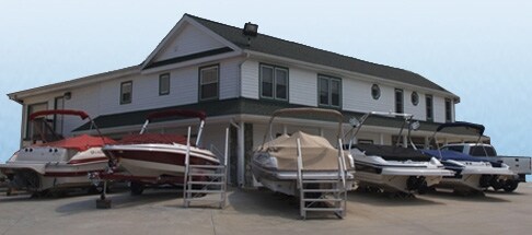

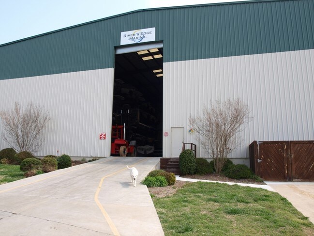

Property Detail
5757 Icard Ridge Rd
0003958
MAP 3705 SUBMAP 77 BLOCK 9370 (PIN) SR 1144 & 1203 A11B 0038
Warehouse
ALEXANDER
HC
North Carolina
AE The base floodplain where base flood elevations are provided. AE Zones are now used on new format FIRMs instead of A1-A30 Zones.
3 AC
2025
Alexander County
2025
Charlotte
0407002031
Hickory-Lenoir-Morganton, NC
10,000 SF
NEARBY LISTINGS FOR SALE OR LEASE
-
-
View all Hickory listings for sale on LoopNet.com
DEMOGRAPHICS near 5757 Icard Ridge Rd
1 mile
3 mile
5 mile
2025 Total Population
1,226
17,178
53,820
2030 Population
1,228
17,582
55,215
Pop Growth 2025-2030
+ 0.16%
+ 2.35%
+ 2.59%
Average Age
45
45
43
2025 Total Households
518
7,208
22,540
HH Growth 2025-2030
0.00%
+ 2.43%
+ 2.72%
Median Household Inc
$82,248
$88,070
$69,967
Avg Household Size
2.40
2.40
2.30
2025 Avg HH Vehicles
2.00
2.00
2.00
Median Home Value
$369,607
$347,540
$295,262
Median Year Built
1990
1991
1984
Nearby Places
Map Layers
Map Styles
 Street
 Aerial
Layers
 Traffic
 Biking
Places
Listings with unknown addresses are not visible on the map
- Restaurants
- Banks
- Shops
- Fitness
- Groceries
Nearby Properties
Address
Land Use
TOTAL SIZE
Lot Size
Zoning
Address
Land Use
TOTAL SIZE
Lot Size
Zoning
16,594 SF
7.22 AC
PD
Address
Land Use
TOTAL SIZE
Lot Size
Zoning
7,722 SF
10.01 AC
R-4
Address
Land Use
TOTAL SIZE
Lot Size
Zoning
17,175 SF
12.17 AC
PD
Address
Land Use
TOTAL SIZE
Lot Size
Zoning
8,637 SF
5 AC
CC-1
Address
Land Use
TOTAL SIZE
Lot Size
Zoning
22,319 SF
15.57 AC
CC-1
Address
Land Use
TOTAL SIZE
Lot Size
Zoning
15,164 SF
8.29 AC
PD
Address
Land Use
TOTAL SIZE
Lot Size
Zoning
22.99 AC
PD
Address
Land Use
TOTAL SIZE
Lot Size
Zoning
24,576 SF
9.15 AC
HC
Address
Land Use
TOTAL SIZE
Lot Size
Zoning
72,388 SF
7.57 AC
R-2
Address
Land Use
TOTAL SIZE
Lot Size
Zoning
51,052 SF
6.80 AC
CC-1
Address
Land Use
TOTAL SIZE
Lot Size
Zoning
46,398 SF
14.16 AC
HC
Address
Land Use
TOTAL SIZE
Lot Size
Zoning
7,185 SF
7.04 AC
R-2
Address
Land Use
TOTAL SIZE
Lot Size
Zoning
70,999 SF
10.22 AC
RA20
Address
Land Use
TOTAL SIZE
Lot Size
Zoning
16.82 AC
R-2
Address
Land Use
TOTAL SIZE
Lot Size
Zoning
51,412 SF
6.51 AC
RA20
Address
Land Use
TOTAL SIZE
Lot Size
Zoning
184.64 AC
R20
Address
Land Use
TOTAL SIZE
Lot Size
Zoning
20,485 SF
5.43 AC
NC
Address
Land Use
TOTAL SIZE
Lot Size
Zoning
14,719 SF
1.67 AC
CC-1
Address
Land Use
TOTAL SIZE
Lot Size
Zoning
15,307 SF
45.83 AC
R-2
Address
Land Use
TOTAL SIZE
Lot Size
Zoning
3.85 AC
CC-1
Address
Land Use
TOTAL SIZE
Lot Size
Zoning
20,436 SF
2.79 AC
PD
Address
Land Use
TOTAL SIZE
Lot Size
Zoning
105,150 SF
5.26 AC
IND
Address
Land Use
TOTAL SIZE
Lot Size
Zoning
7,630 SF
2.60 AC
R-2
Address
Land Use
TOTAL SIZE
Lot Size
Zoning
54,180 SF
5 AC
CC-2
Address
Land Use
TOTAL SIZE
Lot Size
Zoning
18,674 SF
8 AC
Address
Land Use
TOTAL SIZE
Lot Size
Zoning
8,475 SF
3.50 AC
RA20
Address
Land Use
TOTAL SIZE
Lot Size
Zoning
3,840 SF
2.87 AC
CC-1
Address
Land Use
TOTAL SIZE
Lot Size
Zoning
20,865 SF
6.71 AC
R-2
Address
Land Use
TOTAL SIZE
Lot Size
Zoning
16,816 SF
4.44 AC
HC
Address
Land Use
TOTAL SIZE
Lot Size
Zoning
5.98 AC
R-2
The World's #1 Commercial Real Estate Marketplace
Connect with us
© 2026 CoStar Group
The information above has been obtained from sources believed reliable. While we do not doubt its accuracy we have not verified it and make no guarantee, warranty or representation about it. It is your responsibility to independently confirm its accuracy and completeness. Any projections, opinions, assumptions, or estimates used are for example only and do not represent the current or future performance of the property. The value of this transaction to you depends on tax and other factors which should be evaluated by your tax, financial, and legal advisors. You and your advisors should conduct a careful, independent investigation of the property to determine to your satisfaction the suitability of the property for your needs.