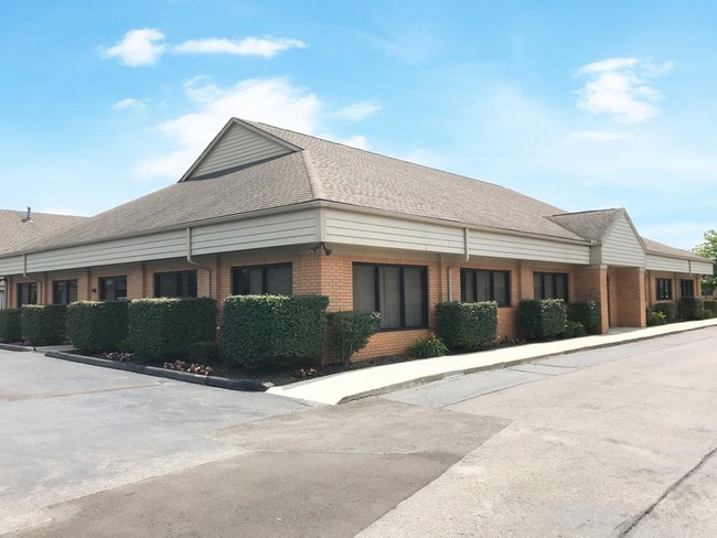
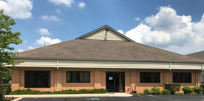
Property Record
5757 W Maple Rd, West Bloomfield, MI 48322

NEARBY LISTINGS FOR SALE OR LEASE
Property Detail
5757 W Maple Rd
18-34-200-236
Oakland County Condominium
Officebuilding
T2N, R9E, SEC 34 OAKLAND COUNTY CONDOMINIUM PLAN NO 1177 MAPLE GLEN COMMONS UNIT 3 L 19979 P 572 5-24-99 FR 005
X
Oakland
26125C0511F
Michigan
2024
0.52 AC
2025
Bloomfield West
157800
Detroit
6,107 SF
Detroit-Warren-Dearborn, MI
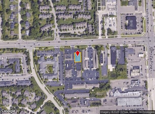
DEMOGRAPHICS near 5757 W Maple Rd
1 mile
3 mile
5 mile
2024 Total Population
9,539
60,741
147,383
2029 Population
9,497
60,065
146,002
Pop Growth 2024-2029
(0.44%)
(1.11%)
(0.94%)
Average Age
45
45
45
2024 Total Households
3,893
23,510
58,607
HH Growth 2024-2029
(0.10%)
(1.00%)
(0.84%)
Median Household Inc
$126,173
$117,529
$110,971
Avg Household Size
2.40
2.50
2.40
2024 Avg HH Vehicles
2.00
2.00
2.00
Median Home Value
$348,188
$368,072
$378,816
Median Year Built
1978
1976
1977
Nearby Places
Map Layers
Map Styles
 Street
 Aerial
Transit
 Traffic
 Biking
Places
Listings with unknown addresses are not visible on the map
- Restaurants
- Banks
- Shops
- Fitness
- Groceries
PUBLIC TRANSPORTATION
COMMUTER RAIL
Drive
Walk
Distance
18 min
8.8 mi
Drive
Walk
Distance
20 min
9.2 mi
AIRPORT
Windsor International
Drive
Walk
Distance
Windsor International
58 min
32.9 mi
Detroit Metro Wayne County
Drive
Walk
Distance
Detroit Metro Wayne County
46 min
33.5 mi
Bishop International
Drive
Walk
Distance
Bishop International
72 min
43.0 mi
SALE & LEASE HISTORY
LISTING DATE
SALE/LEASE

Sep 29, 2017
For Sale
Sep 04, 2025
For Sale
Jun 18, 2018
For Sale
Jul 05, 2018
For Lease
Jul 05, 2018
For Sale
Nearby Properties
Address
Land Use
TOTAL SIZE
Lot Size
Zoning
Address
Land Use
TOTAL SIZE
Lot Size
Zoning
308,191 SF
51.47 AC
RI
Address
Land Use
TOTAL SIZE
Lot Size
Zoning
308,794 SF
76.30 AC
RI
Address
Land Use
TOTAL SIZE
Lot Size
Zoning
45,893 SF
5.62 AC
AI
Address
Land Use
TOTAL SIZE
Lot Size
Zoning
116,086 SF
41.61 AC
RI
Address
Land Use
TOTAL SIZE
Lot Size
Zoning
121,382 SF
10.84 AC
BI
Address
Land Use
TOTAL SIZE
Lot Size
Zoning
110,341 SF
99 AC
RI
Address
Land Use
TOTAL SIZE
Lot Size
Zoning
427,062 SF
31.20 AC
AI
Address
Land Use
TOTAL SIZE
Lot Size
Zoning
411,118 SF
43.95 AC
AI
Address
Land Use
TOTAL SIZE
Lot Size
Zoning
75,146 SF
41.22 AC
RI
Address
Land Use
TOTAL SIZE
Lot Size
Zoning
315,206 SF
3.85 AC
AI
Address
Land Use
TOTAL SIZE
Lot Size
Zoning
204,652 SF
9.62 AC
BI
Address
Land Use
TOTAL SIZE
Lot Size
Zoning
74,297 SF
13 AC
RI
Address
Land Use
TOTAL SIZE
Lot Size
Zoning
82,517 SF
26.39 AC
RI
Address
Land Use
TOTAL SIZE
Lot Size
Zoning
271,650 SF
12.88 AC
BI
Address
Land Use
TOTAL SIZE
Lot Size
Zoning
352,098 SF
28.94 AC
BI
Address
Land Use
TOTAL SIZE
Lot Size
Zoning
Address
Land Use
TOTAL SIZE
Lot Size
Zoning
61,880 SF
18.62 AC
RI
Address
Land Use
TOTAL SIZE
Lot Size
Zoning
246,695 SF
18.46 AC
BI
Address
Land Use
TOTAL SIZE
Lot Size
Zoning
59,857 SF
16.64 AC
RI
Address
Land Use
TOTAL SIZE
Lot Size
Zoning
260,330 SF
21.04 AC
AI
Address
Land Use
TOTAL SIZE
Lot Size
Zoning
276,825 SF
19.05 AC
AI
Address
Land Use
TOTAL SIZE
Lot Size
Zoning
142,043 SF
17.87 AC
AI
Address
Land Use
TOTAL SIZE
Lot Size
Zoning
158,279 SF
3.63 AC
BI
Address
Land Use
TOTAL SIZE
Lot Size
Zoning
244,500 SF
7.80 AC
AI
Address
Land Use
TOTAL SIZE
Lot Size
Zoning
46,541 SF
41.57 AC
RI
Address
Land Use
TOTAL SIZE
Lot Size
Zoning
274,691 SF
19.57 AC
AI
Address
Land Use
TOTAL SIZE
Lot Size
Zoning
167,790 SF
13.33 AC
BI
Address
Land Use
TOTAL SIZE
Lot Size
Zoning
89,878 SF
11.31 AC
BI
Address
Land Use
TOTAL SIZE
Lot Size
Zoning
243,820 SF
19.71 AC
AI
Address
Land Use
TOTAL SIZE
Lot Size
Zoning
253,037 SF
16.97 AC
AI
The World's #1 Commercial Real Estate Marketplace
Connect with us
© 2026 CoStar Group
The information above has been obtained from sources believed reliable. While we do not doubt its accuracy we have not verified it and make no guarantee, warranty or representation about it. It is your responsibility to independently confirm its accuracy and completeness. Any projections, opinions, assumptions, or estimates used are for example only and do not represent the current or future performance of the property. The value of this transaction to you depends on tax and other factors which should be evaluated by your tax, financial, and legal advisors. You and your advisors should conduct a careful, independent investigation of the property to determine to your satisfaction the suitability of the property for your needs.