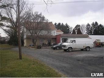
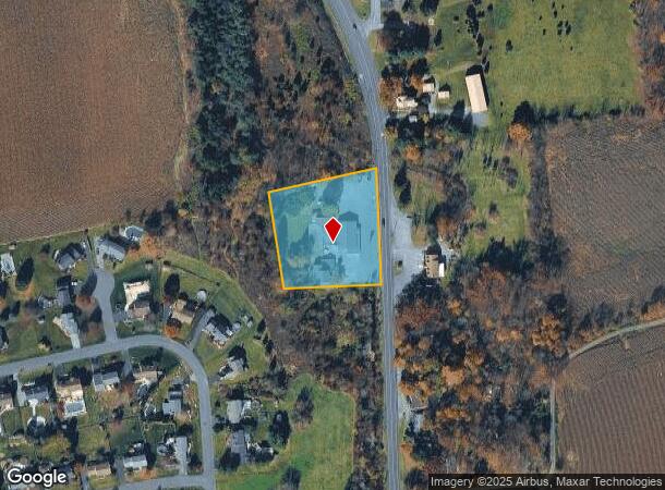
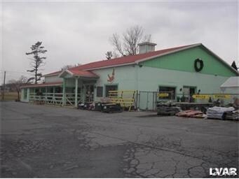
Property Record
5764 Route 145, Laurys Station, PA 18059
NEARBY LISTINGS FOR SALE OR LEASE
Property Detail
5764 Route 145
558126567970-1
LOTS: 059
Apartment
Lehigh
X
Pennsylvania
42095C0206E
59
2025
1.90 AC
2025
Lehigh Valley
005504
Philadelphia
3,535 SF
Allentown-Bethlehem-Easton, PA-NJ
DEMOGRAPHICS near 5764 Route 145
1 Mile
3 Mile
5 Mile
2024 Total Population
1,850
11,971
56,035
2029 Population
1,872
12,026
56,380
Pop Growth 2024-2029
+ 1.19%
+ 0.46%
+ 0.62%
Average Age
43
44
43
2024 Total Households
705
4,681
22,501
HH Growth 2024-2029
+ 1.13%
+ 0.51%
+ 0.66%
Median Household Inc
$82,539
$79,643
$74,807
Avg Household Size
2.60
2.50
2.50
2024 Avg HH Vehicles
2.00
2.00
2.00
Median Home Value
$316,273
$275,596
$242,946
Median Year Built
1980
1979
1974
Nearby Places
Map Layers
Map Styles
 Street
 Aerial
- Restaurants
- Banks
- Shops
- Fitness
- Groceries
PUBLIC TRANSPORTATION
AIRPORT
Lehigh Valley International
DRIVE
WALK
Distance
Lehigh Valley International
17 min
10.0 mi
Freight Ports
Port of Philadelphia
DRIVE
WALK
Distance
Port of Philadelphia
94 min
70.6 mi
SALE & LEASE HISTORY
LISTING DATE
SALE/LEASE

Sep 23, 2016
For Sale
Feb 01, 2018
For Lease
Nearby Properties
Address
Land Use
TOTAL SIZE
Lot Size
Zoning
Address
Land Use
TOTAL SIZE
Lot Size
Zoning
24,878 SF
20.66 AC
AR
Address
Land Use
TOTAL SIZE
Lot Size
Zoning
27,128 SF
1.70 AC
C
Address
Land Use
TOTAL SIZE
Lot Size
Zoning
1,920 SF
26.19 AC
VR
Address
Land Use
TOTAL SIZE
Lot Size
Zoning
9,846 SF
16.67 AC
I
Address
Land Use
TOTAL SIZE
Lot Size
Zoning
23,887 SF
13.91 AC
AR
Address
Land Use
TOTAL SIZE
Lot Size
Zoning
100,361 SF
25.32 AC
R40
Address
Land Use
TOTAL SIZE
Lot Size
Zoning
11,307 SF
4.84 AC
AR
Address
Land Use
TOTAL SIZE
Lot Size
Zoning
51,750 SF
4.31 AC
R3
Address
Land Use
TOTAL SIZE
Lot Size
Zoning
3.50 AC
R-1
Address
Land Use
TOTAL SIZE
Lot Size
Zoning
45,664 SF
93.65 AC
A
Address
Land Use
TOTAL SIZE
Lot Size
Zoning
2.30 AC
R-4
Address
Land Use
TOTAL SIZE
Lot Size
Zoning
6,120 SF
1.79 AC
C
Address
Land Use
TOTAL SIZE
Lot Size
Zoning
19,719 SF
3.68 AC
AR
Address
Land Use
TOTAL SIZE
Lot Size
Zoning
20,500 SF
5.34 AC
OS-1
Address
Land Use
TOTAL SIZE
Lot Size
Zoning
100,559 SF
212.07 AC
R-40
Address
Land Use
TOTAL SIZE
Lot Size
Zoning
16,628 SF
3.31 AC
VR
Address
Land Use
TOTAL SIZE
Lot Size
Zoning
12,996 SF
7 AC
NC
Address
Land Use
TOTAL SIZE
Lot Size
Zoning
22,880 SF
2.96 AC
R3
Address
Land Use
TOTAL SIZE
Lot Size
Zoning
64.61 AC
AR
Address
Land Use
TOTAL SIZE
Lot Size
Zoning
7,120 SF
27.16 AC
I2
Address
Land Use
TOTAL SIZE
Lot Size
Zoning
51.68 AC
AR
Address
Land Use
TOTAL SIZE
Lot Size
Zoning
42,947 SF
6.22 AC
I2
Address
Land Use
TOTAL SIZE
Lot Size
Zoning
2,919 SF
1.43 AC
C
Address
Land Use
TOTAL SIZE
Lot Size
Zoning
27,012 SF
2.90 AC
R-5A
Address
Land Use
TOTAL SIZE
Lot Size
Zoning
67.29 AC
CR
Address
Land Use
TOTAL SIZE
Lot Size
Zoning
9,105 SF
6.58 AC
R40
Address
Land Use
TOTAL SIZE
Lot Size
Zoning
17,459 SF
8.66 AC
R-S
Address
Land Use
TOTAL SIZE
Lot Size
Zoning
5.36 AC
C
Address
Land Use
TOTAL SIZE
Lot Size
Zoning
3,072 SF
60.80 AC
AR
Address
Land Use
TOTAL SIZE
Lot Size
Zoning
32 AC
AR
The World's #1 Commercial Real Estate Marketplace
Connect with us
© 2026 CoStar Group
The information above has been obtained from sources believed reliable. While we do not doubt its accuracy we have not verified it and make no guarantee, warranty or representation about it. It is your responsibility to independently confirm its accuracy and completeness. Any projections, opinions, assumptions, or estimates used are for example only and do not represent the current or future performance of the property. The value of this transaction to you depends on tax and other factors which should be evaluated by your tax, financial, and legal advisors. You and your advisors should conduct a careful, independent investigation of the property to determine to your satisfaction the suitability of the property for your needs.