Property Record
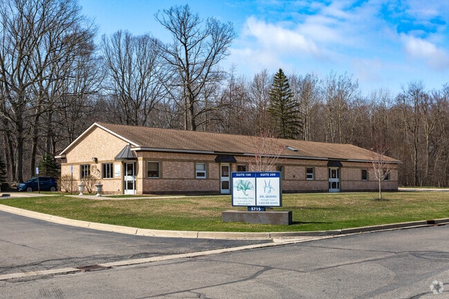
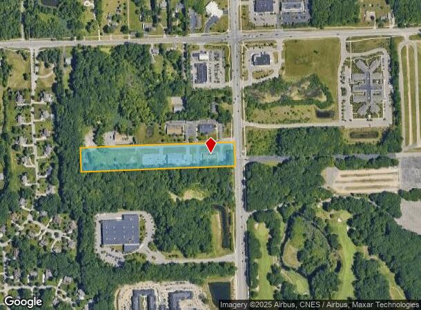
5715 Bella Rosa Blvd, Clarkston, MI 48348
NEARBY LISTINGS FOR SALE OR LEASE
Property Detail
5715 Bella Rosa Blvd
Detroit-Warren-Dearborn, MI
Supervisor's Plat No 5
08-15-376-007
T4N, R9E, SEC 15 SUPERVISOR'S PLAT NO 5 LOT 12
Officebuilding
Oakland
X
Michigan
26125C0332F
12
2024
5.91 AC
2025
St Clair & Lapeer Counties
127100
Detroit
4,394 SF
DEMOGRAPHICS near 5715 Bella Rosa Blvd
1 Mile
3 Mile
5 Mile
2024 Total Population
1,822
28,358
80,100
2029 Population
1,830
28,049
79,337
Pop Growth 2024-2029
+ 0.44%
(1.09%)
(0.95%)
Average Age
42
42
42
2024 Total Households
646
10,622
31,093
HH Growth 2024-2029
+ 0.31%
(1.18%)
(1.04%)
Median Household Inc
$157,241
$108,416
$97,058
Avg Household Size
2.80
2.60
2.50
2024 Avg HH Vehicles
2.00
2.00
2.00
Median Home Value
$407,647
$353,493
$308,531
Median Year Built
1991
1982
1981
Nearby Places
Map Layers
Map Styles
 Street
 Aerial
- Restaurants
- Banks
- Shops
- Fitness
- Groceries
PUBLIC TRANSPORTATION
AIRPORT
Bishop International
DRIVE
WALK
Distance
Bishop International
44 min
30.2 mi
Windsor International
DRIVE
WALK
Distance
Windsor International
69 min
49.4 mi
SALE & LEASE HISTORY
LISTING DATE
SALE/LEASE

Nov 23, 2022
For Lease
Nearby Properties
Address
Land Use
TOTAL SIZE
Lot Size
Zoning
Address
Land Use
TOTAL SIZE
Lot Size
Zoning
388,304 SF
69.09 AC
R2
Address
Land Use
TOTAL SIZE
Lot Size
Zoning
138,009 SF
8.03 AC
PUD
Address
Land Use
TOTAL SIZE
Lot Size
Zoning
17.63 AC
R3
Address
Land Use
TOTAL SIZE
Lot Size
Zoning
208,006 SF
1.24 AC
R2
Address
Land Use
TOTAL SIZE
Lot Size
Zoning
64,763 SF
27.90 AC
PUD
Address
Land Use
TOTAL SIZE
Lot Size
Zoning
34,335 SF
74.71 AC
REC
Address
Land Use
TOTAL SIZE
Lot Size
Zoning
249,200 SF
48.39 AC
R2
Address
Land Use
TOTAL SIZE
Lot Size
Zoning
327,288 SF
19.85 AC
R2
Address
Land Use
TOTAL SIZE
Lot Size
Zoning
78,261 SF
7.80 AC
PUD
Address
Land Use
TOTAL SIZE
Lot Size
Zoning
7.18 AC
PUD
Address
Land Use
TOTAL SIZE
Lot Size
Zoning
35,155 SF
87.55 AC
REC
Address
Land Use
TOTAL SIZE
Lot Size
Zoning
120,673 SF
9.40 AC
IOP
Address
Land Use
TOTAL SIZE
Lot Size
Zoning
87,130 SF
9.01 AC
C-3
Address
Land Use
TOTAL SIZE
Lot Size
Zoning
33,365 SF
320.73 AC
PRD
Address
Land Use
TOTAL SIZE
Lot Size
Zoning
Address
Land Use
TOTAL SIZE
Lot Size
Zoning
151,736 SF
26.03 AC
C-2
Address
Land Use
TOTAL SIZE
Lot Size
Zoning
48,645 SF
6.68 AC
PUD
Address
Land Use
TOTAL SIZE
Lot Size
Zoning
49,169 SF
5.02 AC
PUD
Address
Land Use
TOTAL SIZE
Lot Size
Zoning
117,980 SF
11.33 AC
IOP
Address
Land Use
TOTAL SIZE
Lot Size
Zoning
44,915 SF
0.47 AC
PUD
Address
Land Use
TOTAL SIZE
Lot Size
Zoning
31,068 SF
3 AC
PUD
Address
Land Use
TOTAL SIZE
Lot Size
Zoning
143,550 SF
11.92 AC
R2
Address
Land Use
TOTAL SIZE
Lot Size
Zoning
2,646 SF
27.22 AC
RMT
Address
Land Use
TOTAL SIZE
Lot Size
Zoning
62,944 SF
6.65 AC
C-2
Address
Land Use
TOTAL SIZE
Lot Size
Zoning
34,807 SF
3.34 AC
OS-2
Address
Land Use
TOTAL SIZE
Lot Size
Zoning
97,730 SF
3.91 AC
PUD
Address
Land Use
TOTAL SIZE
Lot Size
Zoning
2,220 SF
80 AC
REC
Address
Land Use
TOTAL SIZE
Lot Size
Zoning
20.33 AC
PUD
Address
Land Use
TOTAL SIZE
Lot Size
Zoning
80,974 SF
8.37 AC
C-3
Address
Land Use
TOTAL SIZE
Lot Size
Zoning
60,282 SF
5.87 AC
C-2
The World's #1 Commercial Real Estate Marketplace
Connect with us
© 2026 CoStar Group
The information above has been obtained from sources believed reliable. While we do not doubt its accuracy we have not verified it and make no guarantee, warranty or representation about it. It is your responsibility to independently confirm its accuracy and completeness. Any projections, opinions, assumptions, or estimates used are for example only and do not represent the current or future performance of the property. The value of this transaction to you depends on tax and other factors which should be evaluated by your tax, financial, and legal advisors. You and your advisors should conduct a careful, independent investigation of the property to determine to your satisfaction the suitability of the property for your needs.