Property Record
5765 Library Rd, Bethel Park, PA 15102
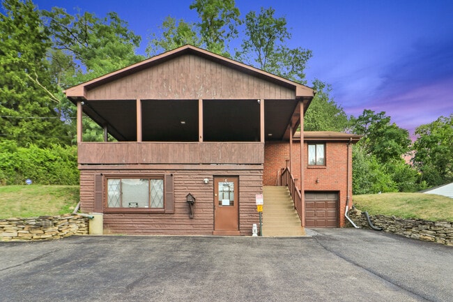

This Property Is For Sale
NEARBY LISTINGS FOR SALE OR LEASE
Property Detail
5765 Library Rd
Pittsburgh, PA
Allegheny
0665-E-00145-0000-00
Pennsylvania
Sfr
0.46 AC
X
South Pittsburgh/Rte 19
42125C0220E
Pittsburgh
1,040 SF
DEMOGRAPHICS near 5765 Library Rd
1 Mile
3 Mile
5 Mile
2024 Total Population
9,792
58,074
168,721
2029 Population
9,572
56,782
165,427
Pop Growth 2024-2029
(2.25%)
(2.22%)
(1.95%)
Average Age
44
44
43
2024 Total Households
3,955
23,839
68,558
HH Growth 2024-2029
(2.35%)
(2.29%)
(2.03%)
Median Household Inc
$110,210
$99,915
$99,286
Avg Household Size
2.40
2.40
2.40
2024 Avg HH Vehicles
2.00
2.00
2.00
Median Home Value
$247,171
$244,993
$252,798
Median Year Built
1964
1966
1963
Nearby Places
Map Layers
Map Styles
 Street
 Aerial
- Restaurants
- Banks
- Shops
- Fitness
- Groceries
PUBLIC TRANSPORTATION
TRANSIT/SUBWAY
Logan (47L Library - Port Authority of Allegheny County Light Rail (The "T"))
DRIVE
WALK
Distance
Logan (47L Library - Port Authority of Allegheny County Light Rail (The "T"))
0 min
2 min
0.1 mi
King's School (47L Library - Port Authority of Allegheny County Light Rail (The "T"))
DRIVE
WALK
Distance
King's School (47L Library - Port Authority of Allegheny County Light Rail (The "T"))
1 min
6 min
0.3 mi
Sarah (47L Library - Port Authority of Allegheny County Light Rail (The "T"))
DRIVE
WALK
Distance
Sarah (47L Library - Port Authority of Allegheny County Light Rail (The "T"))
1 min
7 min
0.3 mi
Beagle (47L Library - Port Authority of Allegheny County Light Rail (The "T"))
DRIVE
WALK
Distance
Beagle (47L Library - Port Authority of Allegheny County Light Rail (The "T"))
2 min
17 min
0.9 mi
Munroe (47L Library - Port Authority of Allegheny County Light Rail (The "T"))
DRIVE
WALK
Distance
Munroe (47L Library - Port Authority of Allegheny County Light Rail (The "T"))
2 min
18 min
0.9 mi
AIRPORT
Pittsburgh International
DRIVE
WALK
Distance
Pittsburgh International
40 min
21.0 mi
Arnold Palmer Regional
DRIVE
WALK
Distance
Arnold Palmer Regional
75 min
40.5 mi
Nearby Properties
Address
Land Use
TOTAL SIZE
Lot Size
Zoning
Address
Land Use
TOTAL SIZE
Lot Size
Zoning
73.76 AC
Address
Land Use
TOTAL SIZE
Lot Size
Zoning
Address
Land Use
TOTAL SIZE
Lot Size
Zoning
237.75 AC
Address
Land Use
TOTAL SIZE
Lot Size
Zoning
101.91 AC
Address
Land Use
TOTAL SIZE
Lot Size
Zoning
31.68 AC
Address
Land Use
TOTAL SIZE
Lot Size
Zoning
40.46 AC
Address
Land Use
TOTAL SIZE
Lot Size
Zoning
28.26 AC
Address
Land Use
TOTAL SIZE
Lot Size
Zoning
10.49 AC
Address
Land Use
TOTAL SIZE
Lot Size
Zoning
58.24 AC
Address
Land Use
TOTAL SIZE
Lot Size
Zoning
7.19 AC
Address
Land Use
TOTAL SIZE
Lot Size
Zoning
31.39 AC
Address
Land Use
TOTAL SIZE
Lot Size
Zoning
Address
Land Use
TOTAL SIZE
Lot Size
Zoning
5.29 AC
Address
Land Use
TOTAL SIZE
Lot Size
Zoning
7.66 AC
Address
Land Use
TOTAL SIZE
Lot Size
Zoning
21.96 AC
Address
Land Use
TOTAL SIZE
Lot Size
Zoning
26.91 AC
Address
Land Use
TOTAL SIZE
Lot Size
Zoning
6.79 AC
Address
Land Use
TOTAL SIZE
Lot Size
Zoning
2,179 SF
1,497.30 AC
Address
Land Use
TOTAL SIZE
Lot Size
Zoning
9.73 AC
Address
Land Use
TOTAL SIZE
Lot Size
Zoning
43.24 AC
Address
Land Use
TOTAL SIZE
Lot Size
Zoning
12.03 AC
Address
Land Use
TOTAL SIZE
Lot Size
Zoning
8.95 AC
Address
Land Use
TOTAL SIZE
Lot Size
Zoning
0.12 AC
Address
Land Use
TOTAL SIZE
Lot Size
Zoning
9.45 AC
Address
Land Use
TOTAL SIZE
Lot Size
Zoning
Address
Land Use
TOTAL SIZE
Lot Size
Zoning
7.78 AC
Address
Land Use
TOTAL SIZE
Lot Size
Zoning
0.12 AC
Address
Land Use
TOTAL SIZE
Lot Size
Zoning
4.53 AC
Address
Land Use
TOTAL SIZE
Lot Size
Zoning
Address
Land Use
TOTAL SIZE
Lot Size
Zoning
The World's #1 Commercial Real Estate Marketplace
Connect with us
© 2026 CoStar Group
The information above has been obtained from sources believed reliable. While we do not doubt its accuracy we have not verified it and make no guarantee, warranty or representation about it. It is your responsibility to independently confirm its accuracy and completeness. Any projections, opinions, assumptions, or estimates used are for example only and do not represent the current or future performance of the property. The value of this transaction to you depends on tax and other factors which should be evaluated by your tax, financial, and legal advisors. You and your advisors should conduct a careful, independent investigation of the property to determine to your satisfaction the suitability of the property for your needs.