Property Record
5765 N Lapeer Rd, North Branch, MI 48461

NEARBY LISTINGS FOR SALE OR LEASE
-
-
View all North Branch listings for sale on LoopNet.com
Property Detail
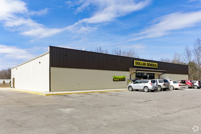
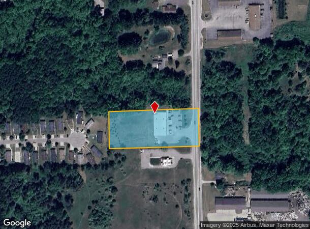
5765 N Lapeer Rd
006-017-025-10
SEC 17 T9N R10E BEG N 01 DEG 41'56 E 111.57 FT FROM THE E 1/4 COR OF SEC
Wholesaleoutletdiscountstore
Lapeer
A
Michigan
26157C0700E
2.53 AC
2024
St Clair & Lapeer Counties
2025
Detroit
332000
Detroit-Warren-Dearborn, MI
9,100 SF
DEMOGRAPHICS near 5765 N Lapeer Rd
1 Mile
3 Mile
5 Mile
2024 Total Population
1,210
4,356
9,892
2029 Population
1,215
4,394
9,921
Pop Growth 2024-2029
+ 0.41%
+ 0.87%
+ 0.29%
Average Age
40
42
42
2024 Total Households
447
1,658
3,706
HH Growth 2024-2029
+ 0.45%
+ 1.03%
+ 0.35%
Median Household Inc
$65,596
$65,582
$66,319
Avg Household Size
2.60
2.60
2.60
2024 Avg HH Vehicles
2.00
2.00
2.00
Median Home Value
$143,883
$151,930
$160,897
Median Year Built
1970
1971
1973
Nearby Places
Map Layers
Map Styles
 Street
 Aerial
- Restaurants
- Banks
- Shops
- Fitness
- Groceries
PUBLIC TRANSPORTATION
AIRPORT
Bishop International
DRIVE
WALK
Distance
Bishop International
57 min
39.1 mi
Freight Ports
Port of Toledo
DRIVE
WALK
Distance
Port of Toledo
165 min
127.6 mi
SALE & LEASE HISTORY
LISTING DATE
SALE/LEASE

Nov 15, 2016
For Sale
Nearby Properties
Address
Land Use
TOTAL SIZE
Lot Size
Zoning
Address
Land Use
TOTAL SIZE
Lot Size
Zoning
624 SF
81.93 AC
C
Address
Land Use
TOTAL SIZE
Lot Size
Zoning
2,582 SF
241.34 AC
R-1
Address
Land Use
TOTAL SIZE
Lot Size
Zoning
8,185 SF
10 AC
C
Address
Land Use
TOTAL SIZE
Lot Size
Zoning
18,500 SF
5 AC
C
Address
Land Use
TOTAL SIZE
Lot Size
Zoning
22,113 SF
2.13 AC
C
Address
Land Use
TOTAL SIZE
Lot Size
Zoning
155 AC
AGRICU
Address
Land Use
TOTAL SIZE
Lot Size
Zoning
6.31 AC
AGRICU
Address
Land Use
TOTAL SIZE
Lot Size
Zoning
47,413 SF
10.06 AC
R-1
Address
Land Use
TOTAL SIZE
Lot Size
Zoning
1,536 SF
151.04 AC
R-1
Address
Land Use
TOTAL SIZE
Lot Size
Zoning
9.81 AC
I
Address
Land Use
TOTAL SIZE
Lot Size
Zoning
6,752 SF
1.87 AC
C
Address
Land Use
TOTAL SIZE
Lot Size
Zoning
1,983 SF
105.62 AC
13
Address
Land Use
TOTAL SIZE
Lot Size
Zoning
2,010 SF
68.60 AC
R-1
Address
Land Use
TOTAL SIZE
Lot Size
Zoning
2,166 SF
80 AC
R-1
Address
Land Use
TOTAL SIZE
Lot Size
Zoning
100.44 AC
R-1
Address
Land Use
TOTAL SIZE
Lot Size
Zoning
960 SF
120 AC
R-1
Address
Land Use
TOTAL SIZE
Lot Size
Zoning
1,360 SF
78.94 AC
R-1
Address
Land Use
TOTAL SIZE
Lot Size
Zoning
38,876 SF
10.38 AC
I
Address
Land Use
TOTAL SIZE
Lot Size
Zoning
1,927 SF
98 AC
AGRICU
Address
Land Use
TOTAL SIZE
Lot Size
Zoning
1,616 SF
79.13 AC
R-1
Address
Land Use
TOTAL SIZE
Lot Size
Zoning
2,650 SF
40 AC
C
Address
Land Use
TOTAL SIZE
Lot Size
Zoning
1,040 SF
80 AC
11
Address
Land Use
TOTAL SIZE
Lot Size
Zoning
117.44 AC
14
Address
Land Use
TOTAL SIZE
Lot Size
Zoning
2,562 SF
1.66 AC
C
Address
Land Use
TOTAL SIZE
Lot Size
Zoning
2,052 SF
80 AC
R-1
Address
Land Use
TOTAL SIZE
Lot Size
Zoning
1,900 SF
52 AC
R-1
Address
Land Use
TOTAL SIZE
Lot Size
Zoning
1,846 SF
84 AC
R-1
Address
Land Use
TOTAL SIZE
Lot Size
Zoning
1,468 SF
68.91 AC
R-1
Address
Land Use
TOTAL SIZE
Lot Size
Zoning
2,250 SF
43.18 AC
R-1
The World's #1 Commercial Real Estate Marketplace
Connect with us
© 2026 CoStar Group
The information above has been obtained from sources believed reliable. While we do not doubt its accuracy we have not verified it and make no guarantee, warranty or representation about it. It is your responsibility to independently confirm its accuracy and completeness. Any projections, opinions, assumptions, or estimates used are for example only and do not represent the current or future performance of the property. The value of this transaction to you depends on tax and other factors which should be evaluated by your tax, financial, and legal advisors. You and your advisors should conduct a careful, independent investigation of the property to determine to your satisfaction the suitability of the property for your needs.