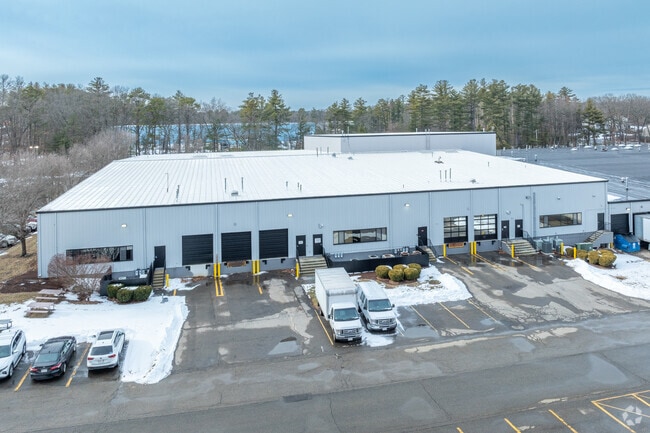
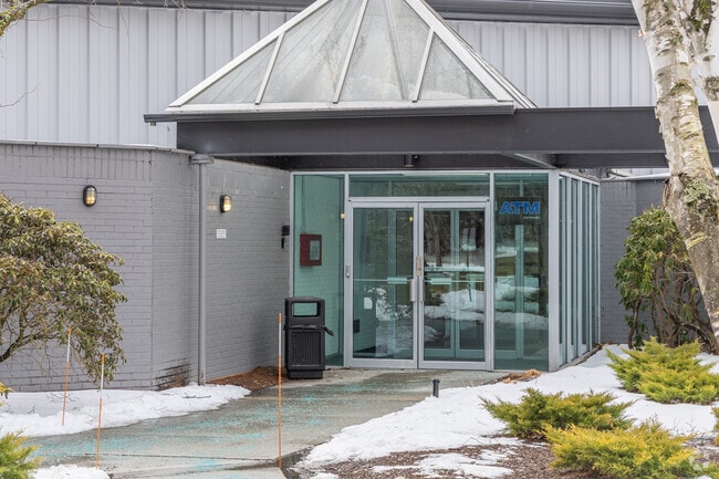
Property Record
577 Main St, Hudson, MA 01749

Current Lease Availabilities
Property Detail
577 Main St
HUDS-000035-000000-000076
Middlesex
Scientificpharmaceuticalmedicalresearchfacility
Massachusetts
M6
76
B and X Area of moderate flood hazard, usually the area between the limits of the 100-year and 500-year floods.
16.05 AC
2025
Concord/Maynard
2025
Boston
322100
Boston-Cambridge-Newton, MA-NH
159,720 SF
NEARBY LISTINGS FOR SALE OR LEASE
-
-
View all Hudson listings for lease on LoopNet.com
DEMOGRAPHICS near 577 Main St
1 mile
3 mile
5 mile
2025 Total Population
2,095
25,908
98,286
2030 Population
2,213
27,035
101,945
Pop Growth 2025-2030
+ 5.63%
+ 4.35%
+ 3.72%
Average Age
45
43
42
2025 Total Households
808
9,739
38,310
HH Growth 2025-2030
+ 5.82%
+ 4.49%
+ 3.82%
Median Household Inc
$201,716
$144,192
$120,710
Avg Household Size
2.60
2.60
2.50
2025 Avg HH Vehicles
2.00
2.00
2.00
Median Home Value
$751,366
$689,859
$644,985
Median Year Built
1990
1979
1972
Nearby Places
Map Layers
Map Styles
 Street
 Aerial
Transit
 Traffic
 Biking
Places
Listings with unknown addresses are not visible on the map
- Restaurants
- Banks
- Shops
- Fitness
- Groceries
PUBLIC TRANSPORTATION
COMMUTER RAIL
South Acton (Fitchburg/South Acton Line - Massachusetts Bay Transportation Authority Commuter Rail (Purple Line))
Drive
Walk
Distance
South Acton (Fitchburg/South Acton Line - Massachusetts Bay Transportation Authority Commuter Rail (Purple Line))
19 min
8.8 mi
AIRPORT
Worcester Regional
Drive
Walk
Distance
Worcester Regional
41 min
24.9 mi
General Edward Lawrence Logan International
Drive
Walk
Distance
General Edward Lawrence Logan International
50 min
30.2 mi
Freight Ports
Port of Boston
Drive
Walk
Distance
Port of Boston
49 min
28.6 mi
Nearby Properties
Address
Land Use
TOTAL SIZE
Lot Size
Zoning
Address
Land Use
TOTAL SIZE
Lot Size
Zoning
284,231 SF
62.04 AC
A2
Address
Land Use
TOTAL SIZE
Lot Size
Zoning
23,890 SF
36.39 AC
A3
Address
Land Use
TOTAL SIZE
Lot Size
Zoning
22.74 AC
A1
Address
Land Use
TOTAL SIZE
Lot Size
Zoning
9.66 AC
A1
Address
Land Use
TOTAL SIZE
Lot Size
Zoning
21.17 AC
A1
Address
Land Use
TOTAL SIZE
Lot Size
Zoning
85,958 SF
13.52 AC
A3
Address
Land Use
TOTAL SIZE
Lot Size
Zoning
46.82 AC
RC
Address
Land Use
TOTAL SIZE
Lot Size
Zoning
16.84 AC
M5
Address
Land Use
TOTAL SIZE
Lot Size
Zoning
71.89 AC
RR
Address
Land Use
TOTAL SIZE
Lot Size
Zoning
815 AC
OS
Address
Land Use
TOTAL SIZE
Lot Size
Zoning
116,597 SF
11.29 AC
B
Address
Land Use
TOTAL SIZE
Lot Size
Zoning
148.66 AC
M6
Address
Land Use
TOTAL SIZE
Lot Size
Zoning
93,315 SF
13 AC
B
Address
Land Use
TOTAL SIZE
Lot Size
Zoning
990.40 AC
RC
Address
Land Use
TOTAL SIZE
Lot Size
Zoning
122.98 AC
SA8
Address
Land Use
TOTAL SIZE
Lot Size
Zoning
28.09 AC
R
Address
Land Use
TOTAL SIZE
Lot Size
Zoning
65.15 AC
WI
Address
Land Use
TOTAL SIZE
Lot Size
Zoning
70,246 SF
16.48 AC
I
Address
Land Use
TOTAL SIZE
Lot Size
Zoning
12.30 AC
B
Address
Land Use
TOTAL SIZE
Lot Size
Zoning
60,290 SF
20.50 AC
SA8
Address
Land Use
TOTAL SIZE
Lot Size
Zoning
107,683 SF
5.59 AC
M5
Address
Land Use
TOTAL SIZE
Lot Size
Zoning
71,873 SF
22.53 AC
RR
Address
Land Use
TOTAL SIZE
Lot Size
Zoning
5.78 AC
B
Address
Land Use
TOTAL SIZE
Lot Size
Zoning
6.62 AC
B
Address
Land Use
TOTAL SIZE
Lot Size
Zoning
80,494 SF
5.12 AC
M4
Address
Land Use
TOTAL SIZE
Lot Size
Zoning
40,928 SF
28.46 AC
M5
Address
Land Use
TOTAL SIZE
Lot Size
Zoning
106,778 SF
8.58 AC
M6
Address
Land Use
TOTAL SIZE
Lot Size
Zoning
208.81 AC
M6
Address
Land Use
TOTAL SIZE
Lot Size
Zoning
217 AC
WI
The World's #1 Commercial Real Estate Marketplace
Connect with us
© 2026 CoStar Group
The information above has been obtained from sources believed reliable. While we do not doubt its accuracy we have not verified it and make no guarantee, warranty or representation about it. It is your responsibility to independently confirm its accuracy and completeness. Any projections, opinions, assumptions, or estimates used are for example only and do not represent the current or future performance of the property. The value of this transaction to you depends on tax and other factors which should be evaluated by your tax, financial, and legal advisors. You and your advisors should conduct a careful, independent investigation of the property to determine to your satisfaction the suitability of the property for your needs.