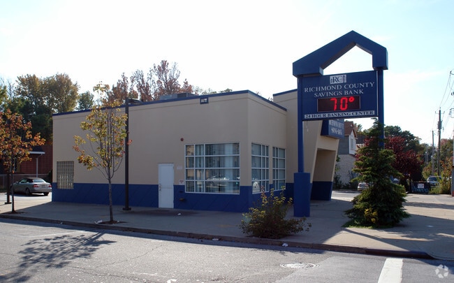
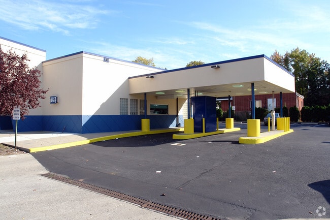
Property Record
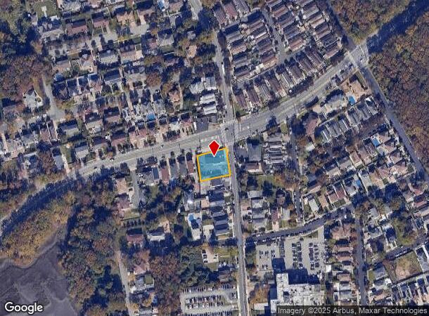
5770 Hylan Blvd, Staten Island, NY 10309
NEARBY LISTINGS FOR SALE OR LEASE
Property Detail
5770 Hylan Blvd
06699-0001
Staten Island
Financialbuilding
New York
X
1
3604970314F
0.31 AC
2024
Staten Island
2025
Long Island (New York)
019800
New York-Jersey City-White Plains, NY-NJ
2,157 SF
DEMOGRAPHICS near 5770 Hylan Blvd
1 Mile
3 Mile
5 Mile
2024 Total Population
9,774
101,890
241,520
2029 Population
9,561
99,870
236,691
Pop Growth 2024-2029
(2.18%)
(1.98%)
(2.00%)
Average Age
42
42
41
2024 Total Households
3,352
36,395
84,681
HH Growth 2024-2029
(2.24%)
(2.09%)
(1.99%)
Median Household Inc
$108,047
$108,306
$90,404
Avg Household Size
2.80
2.80
2.80
2024 Avg HH Vehicles
2.00
2.00
2.00
Median Home Value
$795,835
$698,401
$600,199
Median Year Built
1984
1983
1976
Nearby Places
- Restaurants
- Banks
- Shops
- Fitness
- Groceries
PUBLIC TRANSPORTATION
TRANSIT/SUBWAY
Prince's Bay (Staten Island Railway - New York MTA Subway (The Subway))
DRIVE
WALK
Distance
Prince's Bay (Staten Island Railway - New York MTA Subway (The Subway))
2 min
11 min
0.6 mi
COMMUTER RAIL
Prince's Bay (Staten Island Railway - New York MTA Subway (The Subway))
DRIVE
WALK
Distance
Prince's Bay (Staten Island Railway - New York MTA Subway (The Subway))
2 min
11 min
0.6 mi
Huguenot (Staten Island Railway - New York MTA Subway (The Subway))
DRIVE
WALK
Distance
Huguenot (Staten Island Railway - New York MTA Subway (The Subway))
4 min
1.4 mi
AIRPORT
Newark Liberty International
DRIVE
WALK
Distance
Newark Liberty International
34 min
18.6 mi
LaGuardia
DRIVE
WALK
Distance
LaGuardia
56 min
30.8 mi
John F Kennedy International
DRIVE
WALK
Distance
John F Kennedy International
59 min
33.3 mi
Freight Ports
New York Container Terminal
DRIVE
WALK
Distance
New York Container Terminal
18 min
9.3 mi
Nearby Properties
Address
Land Use
TOTAL SIZE
Lot Size
Zoning
Address
Land Use
TOTAL SIZE
Lot Size
Zoning
411,000 SF
18.54 AC
R3X
Address
Land Use
TOTAL SIZE
Lot Size
Zoning
11,140 SF
170.60 AC
PARK
Address
Land Use
TOTAL SIZE
Lot Size
Zoning
220,240 SF
5.77 AC
R3X
Address
Land Use
TOTAL SIZE
Lot Size
Zoning
38.58 AC
PARK
Address
Land Use
TOTAL SIZE
Lot Size
Zoning
33.36 AC
PARK
Address
Land Use
TOTAL SIZE
Lot Size
Zoning
6,822 SF
29.22 AC
S-2C
Address
Land Use
TOTAL SIZE
Lot Size
Zoning
28.97 AC
PARK
Address
Land Use
TOTAL SIZE
Lot Size
Zoning
15,000 SF
16.63 AC
M1-1
Address
Land Use
TOTAL SIZE
Lot Size
Zoning
135,000 SF
4.54 AC
R3X
Address
Land Use
TOTAL SIZE
Lot Size
Zoning
26.08 AC
PARK
Address
Land Use
TOTAL SIZE
Lot Size
Zoning
180,000 SF
91.83 AC
M3-1
Address
Land Use
TOTAL SIZE
Lot Size
Zoning
192,000 SF
5.47 AC
R3X
Address
Land Use
TOTAL SIZE
Lot Size
Zoning
188,692 SF
9.66 AC
R3-2
Address
Land Use
TOTAL SIZE
Lot Size
Zoning
109,000 SF
3.38 AC
R3X
Address
Land Use
TOTAL SIZE
Lot Size
Zoning
27.90 AC
R3X
Address
Land Use
TOTAL SIZE
Lot Size
Zoning
75,000 SF
16.72 AC
R3X
Address
Land Use
TOTAL SIZE
Lot Size
Zoning
386,608 SF
69.19 AC
M3-1
Address
Land Use
TOTAL SIZE
Lot Size
Zoning
757,858 SF
126.31 AC
R3X
Address
Land Use
TOTAL SIZE
Lot Size
Zoning
100,780 SF
3.60 AC
R1-2
Address
Land Use
TOTAL SIZE
Lot Size
Zoning
688 SF
14.76 AC
S-2C
Address
Land Use
TOTAL SIZE
Lot Size
Zoning
159,600 SF
11.24 AC
M2-1
Address
Land Use
TOTAL SIZE
Lot Size
Zoning
102,323 SF
2.76 AC
R3-2
Address
Land Use
TOTAL SIZE
Lot Size
Zoning
135,000 SF
3.95 AC
R3A
Address
Land Use
TOTAL SIZE
Lot Size
Zoning
14.92 AC
PARK
Address
Land Use
TOTAL SIZE
Lot Size
Zoning
65,476 SF
2.48 AC
R3-2
Address
Land Use
TOTAL SIZE
Lot Size
Zoning
144,760 SF
12.10 AC
M1-1
Address
Land Use
TOTAL SIZE
Lot Size
Zoning
155,282 SF
12.37 AC
M1-1
Address
Land Use
TOTAL SIZE
Lot Size
Zoning
66,484 SF
9.15 AC
R3X
Address
Land Use
TOTAL SIZE
Lot Size
Zoning
21.50 AC
S-3A
Address
Land Use
TOTAL SIZE
Lot Size
Zoning
10.03 AC
PARK
The World's #1 Commercial Real Estate Marketplace
Connect with us
© 2025 CoStar Group
The information above has been obtained from sources believed reliable. While we do not doubt its accuracy we have not verified it and make no guarantee, warranty or representation about it. It is your responsibility to independently confirm its accuracy and completeness. Any projections, opinions, assumptions, or estimates used are for example only and do not represent the current or future performance of the property. The value of this transaction to you depends on tax and other factors which should be evaluated by your tax, financial, and legal advisors. You and your advisors should conduct a careful, independent investigation of the property to determine to your satisfaction the suitability of the property for your needs.