Property Record
5770 Sherwood Way, San Angelo, TX 76901
NEARBY LISTINGS FOR SALE OR LEASE
Property Detail
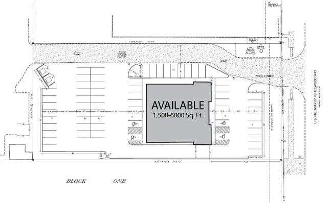
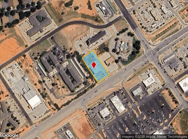
5770 Sherwood Way
San Angelo, TX
Far West Add
10-22705-0001-003-00
ACRES: 1.097 LOT: 3 - BEING 1.0970 ACRES SECTION 2 BLK: 1 SUBD: FAR WEST ADDITION
Storebuilding
Tom Green
X
Texas
48451C0470E
3
2025
1.10 AC
2025
Texas West Area
001710
Other Market Areas
6,715 SF
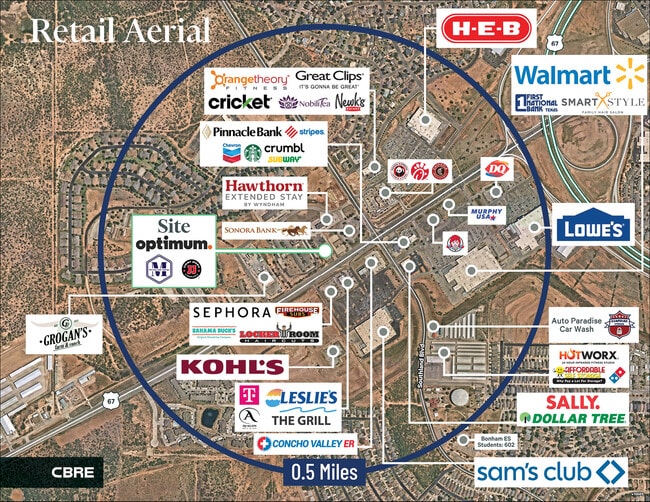
DEMOGRAPHICS near 5770 Sherwood Way
1 Mile
3 Mile
5 Mile
2024 Total Population
6,165
33,460
64,058
2029 Population
6,168
33,216
63,828
Pop Growth 2024-2029
+ 0.05%
(0.73%)
(0.36%)
Average Age
39
39
38
2024 Total Households
2,699
14,136
26,491
HH Growth 2024-2029
(0.15%)
(0.81%)
(0.40%)
Median Household Inc
$77,411
$71,599
$65,932
Avg Household Size
2.20
2.30
2.30
2024 Avg HH Vehicles
2.00
2.00
2.00
Median Home Value
$220,905
$202,380
$181,968
Median Year Built
2001
1983
1978
Nearby Places
- Restaurants
- Banks
- Shops
- Fitness
- Groceries
PUBLIC TRANSPORTATION
AIRPORT
San Angelo Regional/Mathis Field
DRIVE
WALK
Distance
San Angelo Regional/Mathis Field
14 min
7.9 mi
Freight Ports
Calhoun Port
DRIVE
WALK
Distance
Calhoun Port
397 min
360.7 mi
SALE & LEASE HISTORY
LISTING DATE
SALE/LEASE

Oct 12, 2017
For Lease
Oct 12, 2017
For Lease
Aug 21, 2023
For Sale
Nearby Properties
Address
Land Use
TOTAL SIZE
Lot Size
Zoning
Address
Land Use
TOTAL SIZE
Lot Size
Zoning
189,402 SF
18.09 AC
Address
Land Use
TOTAL SIZE
Lot Size
Zoning
205,985 SF
15 AC
Address
Land Use
TOTAL SIZE
Lot Size
Zoning
183,667 SF
10.74 AC
Address
Land Use
TOTAL SIZE
Lot Size
Zoning
230,352 SF
14.95 AC
Address
Land Use
TOTAL SIZE
Lot Size
Zoning
159,506 SF
9.76 AC
Address
Land Use
TOTAL SIZE
Lot Size
Zoning
171,120 SF
9.46 AC
Address
Land Use
TOTAL SIZE
Lot Size
Zoning
91,978 SF
8.42 AC
Address
Land Use
TOTAL SIZE
Lot Size
Zoning
142,715 SF
8.22 AC
Address
Land Use
TOTAL SIZE
Lot Size
Zoning
149,980 SF
9.42 AC
Address
Land Use
TOTAL SIZE
Lot Size
Zoning
202,670 SF
23.87 AC
Address
Land Use
TOTAL SIZE
Lot Size
Zoning
147,240 SF
8.91 AC
Address
Land Use
TOTAL SIZE
Lot Size
Zoning
164,896 SF
11.83 AC
Address
Land Use
TOTAL SIZE
Lot Size
Zoning
196,559 SF
20.89 AC
Address
Land Use
TOTAL SIZE
Lot Size
Zoning
26,375 SF
7.69 AC
Address
Land Use
TOTAL SIZE
Lot Size
Zoning
149,516 SF
7.40 AC
Address
Land Use
TOTAL SIZE
Lot Size
Zoning
149,703 SF
8.53 AC
Address
Land Use
TOTAL SIZE
Lot Size
Zoning
36,000 SF
6.42 AC
Address
Land Use
TOTAL SIZE
Lot Size
Zoning
320,000 SF
21.48 AC
Address
Land Use
TOTAL SIZE
Lot Size
Zoning
242,426 SF
9.04 AC
Address
Land Use
TOTAL SIZE
Lot Size
Zoning
58,282 SF
5.19 AC
Address
Land Use
TOTAL SIZE
Lot Size
Zoning
121,135 SF
9.51 AC
Address
Land Use
TOTAL SIZE
Lot Size
Zoning
93,987 SF
13.86 AC
Address
Land Use
TOTAL SIZE
Lot Size
Zoning
122,320 SF
6 AC
Address
Land Use
TOTAL SIZE
Lot Size
Zoning
40,451 SF
5.22 AC
Address
Land Use
TOTAL SIZE
Lot Size
Zoning
Address
Land Use
TOTAL SIZE
Lot Size
Zoning
24,570 SF
16 AC
Address
Land Use
TOTAL SIZE
Lot Size
Zoning
44,310 SF
2.26 AC
Address
Land Use
TOTAL SIZE
Lot Size
Zoning
69,300 SF
3.04 AC
Address
Land Use
TOTAL SIZE
Lot Size
Zoning
52,260 SF
2.24 AC
Address
Land Use
TOTAL SIZE
Lot Size
Zoning
179,000 SF
8.57 AC
The World's #1 Commercial Real Estate Marketplace
Connect with us
© 2025 CoStar Group
The information above has been obtained from sources believed reliable. While we do not doubt its accuracy we have not verified it and make no guarantee, warranty or representation about it. It is your responsibility to independently confirm its accuracy and completeness. Any projections, opinions, assumptions, or estimates used are for example only and do not represent the current or future performance of the property. The value of this transaction to you depends on tax and other factors which should be evaluated by your tax, financial, and legal advisors. You and your advisors should conduct a careful, independent investigation of the property to determine to your satisfaction the suitability of the property for your needs.