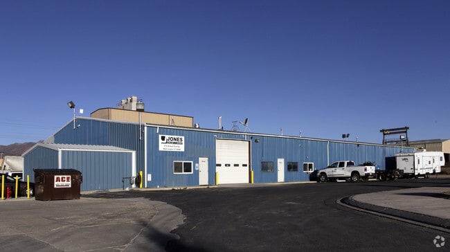
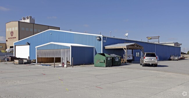
Property Record
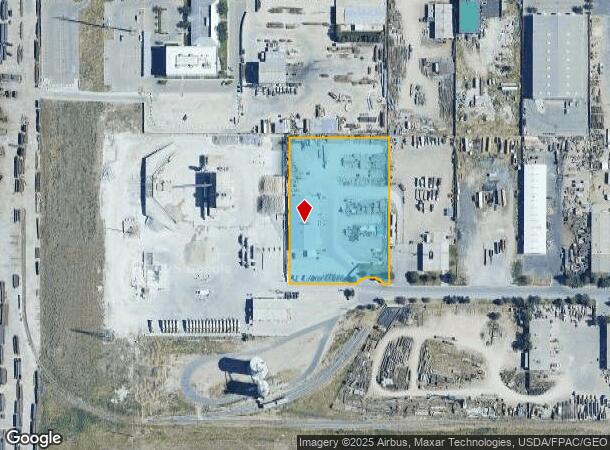
5776 W Axel Rd Park, West Jordan, UT 84088
NEARBY LISTINGS FOR SALE OR LEASE
Property Detail
5776 W Axel Rd Park
Salt Lake City, UT
Radius Curve
26-11-200-039-0000
BEG N 1^0615 E 878.71 FT & N 89^48 W 804 FT FR E 1/4 COR SEC 11, T 3S, R 2W, SLM; N 89^48 W 300 FT; S 0^06 W 433.4 FT; S 89^48 E 199.50 FT; NELY ALG A 50 FT RADIUS CURVE TO R 86.78 FT; ELY ALG 15 FT RADIUS CURVE TO L 12.09 FT; S 89^48 E 12 FT; N 0^06
Lightindustrial
Salt Lake
X
Utah
49035C0410G
12
2024
2.96 AC
2025
West Jordan
112921
Salt Lake City
13,491 SF
DEMOGRAPHICS near 5776 W Axel Rd Park
1 Mile
3 Mile
5 Mile
2024 Total Population
2,721
92,320
227,953
2029 Population
2,863
94,795
232,000
Pop Growth 2024-2029
+ 5.22%
+ 2.68%
+ 1.78%
Average Age
30
33
34
2024 Total Households
822
26,486
66,188
HH Growth 2024-2029
+ 5.35%
+ 2.70%
+ 1.72%
Median Household Inc
$64,256
$107,030
$99,603
Avg Household Size
3.20
3.40
3.40
2024 Avg HH Vehicles
2.00
2.00
2.00
Median Home Value
$592,222
$479,019
$454,416
Median Year Built
2010
2009
2003
Nearby Places
Map Layers
Map Styles
 Street
 Aerial
- Restaurants
- Banks
- Shops
- Fitness
- Groceries
PUBLIC TRANSPORTATION
COMMUTER RAIL
DRIVE
WALK
Distance
18 min
8.6 mi
AIRPORT
Salt Lake City International
DRIVE
WALK
Distance
Salt Lake City International
26 min
17.4 mi
Provo Municipal
DRIVE
WALK
Distance
Provo Municipal
50 min
36.8 mi
Nearby Properties
Address
Land Use
TOTAL SIZE
Lot Size
Zoning
Address
Land Use
TOTAL SIZE
Lot Size
Zoning
340,894 SF
60.46 AC
P-C
Address
Land Use
TOTAL SIZE
Lot Size
Zoning
1,328,525 SF
76.12 AC
A-20
Address
Land Use
TOTAL SIZE
Lot Size
Zoning
338,177 SF
21.91 AC
M-1
Address
Land Use
TOTAL SIZE
Lot Size
Zoning
285,200 SF
55.78 AC
1210
Address
Land Use
TOTAL SIZE
Lot Size
Zoning
233,853 SF
6.05 AC
HFR
Address
Land Use
TOTAL SIZE
Lot Size
Zoning
126,150 SF
25.43 AC
RM
Address
Land Use
TOTAL SIZE
Lot Size
Zoning
308,722 SF
21.29 AC
M-1
Address
Land Use
TOTAL SIZE
Lot Size
Zoning
1,042,750 SF
55.65 AC
M-1
Address
Land Use
TOTAL SIZE
Lot Size
Zoning
362,000 SF
51.81 AC
P-F
Address
Land Use
TOTAL SIZE
Lot Size
Zoning
591,044 SF
13.87 AC
C-2
Address
Land Use
TOTAL SIZE
Lot Size
Zoning
469,074 SF
5.14 AC
C-P
Address
Land Use
TOTAL SIZE
Lot Size
Zoning
702,100 SF
13.83 AC
P-C
Address
Land Use
TOTAL SIZE
Lot Size
Zoning
73,318 SF
1.36 AC
PC
Address
Land Use
TOTAL SIZE
Lot Size
Zoning
241,215 SF
51.07 AC
M-1
Address
Land Use
TOTAL SIZE
Lot Size
Zoning
857,680 SF
75.49 AC
M-1
Address
Land Use
TOTAL SIZE
Lot Size
Zoning
219,020 SF
93.27 AC
M-1
Address
Land Use
TOTAL SIZE
Lot Size
Zoning
609,061 SF
40 AC
M-1
Address
Land Use
TOTAL SIZE
Lot Size
Zoning
204,793 SF
53.90 AC
M-1
Address
Land Use
TOTAL SIZE
Lot Size
Zoning
308,722 SF
20.45 AC
M-1
Address
Land Use
TOTAL SIZE
Lot Size
Zoning
321,528 SF
15.77 AC
R-3-16
Address
Land Use
TOTAL SIZE
Lot Size
Zoning
256,167 SF
13.56 AC
P-C
Address
Land Use
TOTAL SIZE
Lot Size
Zoning
137,750 SF
12.64 AC
1210
Address
Land Use
TOTAL SIZE
Lot Size
Zoning
188,632 SF
12.11 AC
PC
Address
Land Use
TOTAL SIZE
Lot Size
Zoning
256,933 SF
19.68 AC
P-C
Address
Land Use
TOTAL SIZE
Lot Size
Zoning
59,711 SF
4.77 AC
C-2
Address
Land Use
TOTAL SIZE
Lot Size
Zoning
425,753 SF
2.28 AC
PC
Address
Land Use
TOTAL SIZE
Lot Size
Zoning
348,043 SF
5.35 AC
PC
Address
Land Use
TOTAL SIZE
Lot Size
Zoning
536,706 SF
12.80 AC
SC-2
Address
Land Use
TOTAL SIZE
Lot Size
Zoning
348,917 SF
6.23 AC
PC
Address
Land Use
TOTAL SIZE
Lot Size
Zoning
200,665 SF
20.95 AC
4192
The World's #1 Commercial Real Estate Marketplace
Connect with us
© 2025 CoStar Group
The information above has been obtained from sources believed reliable. While we do not doubt its accuracy we have not verified it and make no guarantee, warranty or representation about it. It is your responsibility to independently confirm its accuracy and completeness. Any projections, opinions, assumptions, or estimates used are for example only and do not represent the current or future performance of the property. The value of this transaction to you depends on tax and other factors which should be evaluated by your tax, financial, and legal advisors. You and your advisors should conduct a careful, independent investigation of the property to determine to your satisfaction the suitability of the property for your needs.