Property Record
5788 Barrett Rd, Ferndale, WA 98248


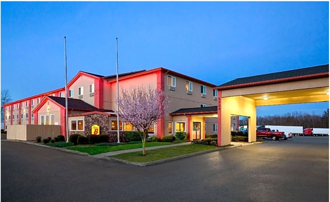
This Property Is For Sale
NEARBY LISTINGS FOR SALE OR LEASE
-
-
View all Ferndale listings for sale on LoopNet.com
Property Detail
5788 Barrett Rd
Bellingham, WA
Barrett Creek Short Pl 2Nd Am
390221-021059-0000
LOT 2 BARRETT CREEK SHORT PLAT 2ND AM AS REC BOOK 33 SHORT PLATS PG 53
Hotel
Whatcom
AE
Washington
53073C1180E
2
2025
2.63 AC
2025
Bellingham/Northwest
010600
Other Market Areas
34,952 SF
DEMOGRAPHICS near 5788 Barrett Rd
1 Mile
3 Mile
5 Mile
2024 Total Population
1,957
20,463
34,494
2029 Population
2,020
21,283
35,896
Pop Growth 2024-2029
+ 3.22%
+ 4.01%
+ 4.06%
Average Age
39
39
40
2024 Total Households
733
7,266
12,701
HH Growth 2024-2029
+ 3.00%
+ 3.85%
+ 4.02%
Median Household Inc
$88,124
$91,646
$81,664
Avg Household Size
2.60
2.80
2.70
2024 Avg HH Vehicles
2.00
2.00
2.00
Median Home Value
$479,203
$520,697
$519,008
Median Year Built
1984
1989
1992
Nearby Places
Map Layers
Map Styles
 Street
 Aerial
- Restaurants
- Banks
- Shops
- Fitness
- Groceries
PUBLIC TRANSPORTATION
AIRPORT
Bellingham International
DRIVE
WALK
Distance
Bellingham International
11 min
6.3 mi
Abbotsford International
DRIVE
WALK
Distance
Abbotsford International
47 min
25.5 mi
Nearby Properties
Address
Land Use
TOTAL SIZE
Lot Size
Zoning
Address
Land Use
TOTAL SIZE
Lot Size
Zoning
1,965 SF
18.02 AC
MCD
Address
Land Use
TOTAL SIZE
Lot Size
Zoning
37,698 SF
8.43 AC
GB
Address
Land Use
TOTAL SIZE
Lot Size
Zoning
2,059 SF
8.02 AC
RM
Address
Land Use
TOTAL SIZE
Lot Size
Zoning
116,159 SF
24.54 AC
P
Address
Land Use
TOTAL SIZE
Lot Size
Zoning
63,802 SF
8.93 AC
MCD
Address
Land Use
TOTAL SIZE
Lot Size
Zoning
74,027 SF
3.54 AC
RO
Address
Land Use
TOTAL SIZE
Lot Size
Zoning
235,594 SF
56.15 AC
PBI
Address
Land Use
TOTAL SIZE
Lot Size
Zoning
66,344 SF
4.30 AC
RO
Address
Land Use
TOTAL SIZE
Lot Size
Zoning
2,044 SF
6.63 AC
P
Address
Land Use
TOTAL SIZE
Lot Size
Zoning
64,509 SF
4.40 AC
GB
Address
Land Use
TOTAL SIZE
Lot Size
Zoning
156,099 SF
11.44 AC
GB
Address
Land Use
TOTAL SIZE
Lot Size
Zoning
153,557 SF
39.70 AC
PBI
Address
Land Use
TOTAL SIZE
Lot Size
Zoning
140,381 SF
9.76 AC
M
Address
Land Use
TOTAL SIZE
Lot Size
Zoning
60,446 SF
4.03 AC
PBI
Address
Land Use
TOTAL SIZE
Lot Size
Zoning
7,132 SF
1.40 AC
MCD
Address
Land Use
TOTAL SIZE
Lot Size
Zoning
77,782 SF
5.90 AC
GB
Address
Land Use
TOTAL SIZE
Lot Size
Zoning
49,744 SF
5.92 AC
GB
Address
Land Use
TOTAL SIZE
Lot Size
Zoning
1,536 SF
5 AC
RM1.5
Address
Land Use
TOTAL SIZE
Lot Size
Zoning
48,409 SF
2.24 AC
GB
Address
Land Use
TOTAL SIZE
Lot Size
Zoning
60,880 SF
6.13 AC
LI
Address
Land Use
TOTAL SIZE
Lot Size
Zoning
23,499 SF
4.46 AC
MCD
Address
Land Use
TOTAL SIZE
Lot Size
Zoning
48,728 SF
2.30 AC
RM1.5
Address
Land Use
TOTAL SIZE
Lot Size
Zoning
46,333 SF
2.03 AC
RM1.5
Address
Land Use
TOTAL SIZE
Lot Size
Zoning
56,084 SF
2.75 AC
LI
Address
Land Use
TOTAL SIZE
Lot Size
Zoning
52,100 SF
4.07 AC
GB
Address
Land Use
TOTAL SIZE
Lot Size
Zoning
59,899 SF
2.94 AC
GB
Address
Land Use
TOTAL SIZE
Lot Size
Zoning
64,175 SF
3.03 AC
LI
Address
Land Use
TOTAL SIZE
Lot Size
Zoning
122,762 SF
146.88 AC
R5A
Address
Land Use
TOTAL SIZE
Lot Size
Zoning
17,415 SF
332.54 AC
ROS
Address
Land Use
TOTAL SIZE
Lot Size
Zoning
48,622 SF
4.34 AC
GB
The World's #1 Commercial Real Estate Marketplace
Connect with us
© 2026 CoStar Group
The information above has been obtained from sources believed reliable. While we do not doubt its accuracy we have not verified it and make no guarantee, warranty or representation about it. It is your responsibility to independently confirm its accuracy and completeness. Any projections, opinions, assumptions, or estimates used are for example only and do not represent the current or future performance of the property. The value of this transaction to you depends on tax and other factors which should be evaluated by your tax, financial, and legal advisors. You and your advisors should conduct a careful, independent investigation of the property to determine to your satisfaction the suitability of the property for your needs.