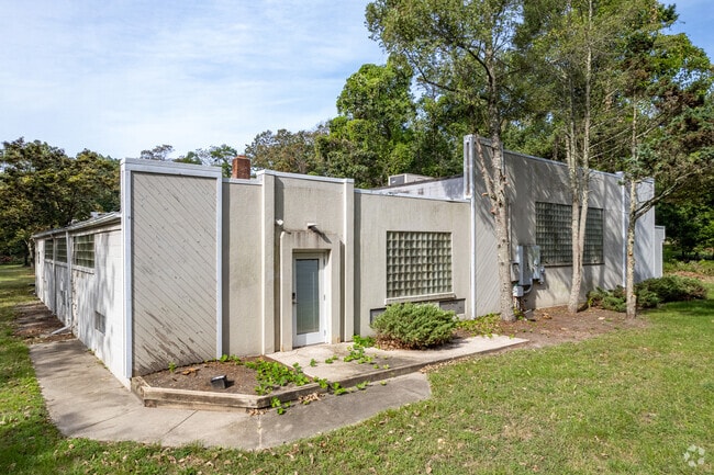
Property Record
579 3Rd St, Atco, NJ 08004

NEARBY LISTINGS FOR SALE OR LEASE
Property Detail
579 3Rd St
35-01309-0000-00004
ADDITIONAL LOTS: INTERPROD/FACILITY NAME: OFFICE
Commercialnec
Camden
X
New Jersey
34007C0145E
4
2024
1.03 AC
2025
Camden County
608901
Philadelphia
10,616 SF
Philadelphia-Camden-Wilmington, PA-NJ-DE-MD
DEMOGRAPHICS near 579 3Rd St
1 Mile
3 Mile
5 Mile
2024 Total Population
4,283
22,364
48,905
2029 Population
4,262
22,634
49,156
Pop Growth 2024-2029
(0.49%)
+ 1.21%
+ 0.51%
Average Age
42
42
42
2024 Total Households
1,541
8,405
18,142
HH Growth 2024-2029
(0.58%)
+ 1.36%
+ 0.60%
Median Household Inc
$94,213
$95,921
$103,617
Avg Household Size
2.60
2.60
2.60
2024 Avg HH Vehicles
2.00
2.00
2.00
Median Home Value
$241,382
$258,470
$277,225
Median Year Built
1976
1978
1978
Nearby Places
Map Layers
Map Styles
 Street
 Aerial
- Restaurants
- Banks
- Shops
- Fitness
- Groceries
PUBLIC TRANSPORTATION
COMMUTER RAIL
Atco (Atlantic City Line - NJ Transit Commuter Rail (NJ Transit))
DRIVE
WALK
Distance
Atco (Atlantic City Line - NJ Transit Commuter Rail (NJ Transit))
5 min
2.7 mi
Lindenwold (Njt) (Atlantic City Line - NJ Transit Commuter Rail (NJ Transit))
DRIVE
WALK
Distance
Lindenwold (Njt) (Atlantic City Line - NJ Transit Commuter Rail (NJ Transit))
12 min
8.8 mi
AIRPORT
Philadelphia International
DRIVE
WALK
Distance
Philadelphia International
42 min
27.5 mi
Atlantic City International
DRIVE
WALK
Distance
Atlantic City International
61 min
31.8 mi
Freight Ports
Broadway Terminal - Pier 5
DRIVE
WALK
Distance
Broadway Terminal - Pier 5
26 min
19.0 mi
SALE & LEASE HISTORY
LISTING DATE
SALE/LEASE

Sep 24, 2016
For Sale
Mar 03, 2017
For Sale
Aug 18, 2023
For Lease
Aug 18, 2023
For Sale
Nearby Properties
Address
Land Use
TOTAL SIZE
Lot Size
Zoning
Address
Land Use
TOTAL SIZE
Lot Size
Zoning
6,208 SF
30.73 AC
PARC
Address
Land Use
TOTAL SIZE
Lot Size
Zoning
137.33 AC
PR3
Address
Land Use
TOTAL SIZE
Lot Size
Zoning
88.36 AC
PR4
Address
Land Use
TOTAL SIZE
Lot Size
Zoning
73.95 AC
PI3
Address
Land Use
TOTAL SIZE
Lot Size
Zoning
27.18 AC
PR4
Address
Land Use
TOTAL SIZE
Lot Size
Zoning
69,324 SF
20.26 AC
Address
Land Use
TOTAL SIZE
Lot Size
Zoning
59,361 SF
19.21 AC
INST
Address
Land Use
TOTAL SIZE
Lot Size
Zoning
22.93 AC
PC-2
Address
Land Use
TOTAL SIZE
Lot Size
Zoning
14.10 AC
RD-1
Address
Land Use
TOTAL SIZE
Lot Size
Zoning
8.56 AC
PARC
Address
Land Use
TOTAL SIZE
Lot Size
Zoning
5.06 AC
PF
Address
Land Use
TOTAL SIZE
Lot Size
Zoning
15.84 AC
RPF
Address
Land Use
TOTAL SIZE
Lot Size
Zoning
23.77 AC
RPF
Address
Land Use
TOTAL SIZE
Lot Size
Zoning
7.07 AC
PF
Address
Land Use
TOTAL SIZE
Lot Size
Zoning
20.99 AC
C-2
Address
Land Use
TOTAL SIZE
Lot Size
Zoning
6.20 AC
Address
Land Use
TOTAL SIZE
Lot Size
Zoning
73.95 AC
PI3
Address
Land Use
TOTAL SIZE
Lot Size
Zoning
5,702 SF
3.28 AC
C-3
Address
Land Use
TOTAL SIZE
Lot Size
Zoning
1,341 SF
1.98 AC
PHB
Address
Land Use
TOTAL SIZE
Lot Size
Zoning
Address
Land Use
TOTAL SIZE
Lot Size
Zoning
38.85 AC
PHB
Address
Land Use
TOTAL SIZE
Lot Size
Zoning
1.64 AC
INS
Address
Land Use
TOTAL SIZE
Lot Size
Zoning
10.72 AC
PI1
Address
Land Use
TOTAL SIZE
Lot Size
Zoning
18,934 SF
5.99 AC
C2RG
Address
Land Use
TOTAL SIZE
Lot Size
Zoning
4.67 AC
PC2
Address
Land Use
TOTAL SIZE
Lot Size
Zoning
2.23 AC
Address
Land Use
TOTAL SIZE
Lot Size
Zoning
9,900 SF
154 AC
RPF
Address
Land Use
TOTAL SIZE
Lot Size
Zoning
2.66 AC
R-3
Address
Land Use
TOTAL SIZE
Lot Size
Zoning
14,594 SF
1.67 AC
PHB
Address
Land Use
TOTAL SIZE
Lot Size
Zoning
5.76 AC
PHB
The World's #1 Commercial Real Estate Marketplace
Connect with us
© 2025 CoStar Group
The information above has been obtained from sources believed reliable. While we do not doubt its accuracy we have not verified it and make no guarantee, warranty or representation about it. It is your responsibility to independently confirm its accuracy and completeness. Any projections, opinions, assumptions, or estimates used are for example only and do not represent the current or future performance of the property. The value of this transaction to you depends on tax and other factors which should be evaluated by your tax, financial, and legal advisors. You and your advisors should conduct a careful, independent investigation of the property to determine to your satisfaction the suitability of the property for your needs.