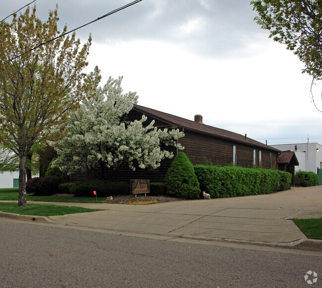
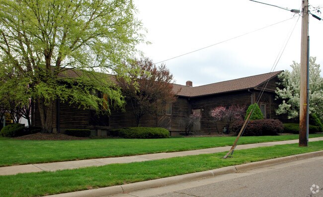
Property Record
579 Baird St, Akron, OH 44311
Save to a Folder
{{folder.Name}}
{{folder.ListingIds.length}} Properties
{{folder.ListingIds.length}} Property
Create a New Folder
Property Detail
579 Baird St
Akron, OH
BROWN ST LOT 245 ALL
67-02178
SUMMIT
Industrialgeneral
Ohio
B and X Area of moderate flood hazard, usually the area between the limits of the 100-year and 500-year floods.
245
2025
0.11 AC
2026
Akron
506800
Cleveland
5,856 SF
NEARBY LISTINGS FOR SALE OR LEASE
DEMOGRAPHICS near 579 Baird St
1 mile
3 mile
5 mile
2025 Total Population
16,359
101,601
211,292
2030 Population
16,660
102,398
211,983
Pop Growth 2025-2030
+ 1.84%
+ 0.78%
+ 0.33%
Average Age
36
38
40
2025 Total Households
6,637
42,605
91,259
HH Growth 2025-2030
+ 1.85%
+ 0.74%
+ 0.29%
Median Household Inc
$41,221
$40,566
$48,819
Avg Household Size
2.30
2.20
2.20
2025 Avg HH Vehicles
1.00
1.00
2.00
Median Home Value
$69,812
$92,084
$133,755
Median Year Built
1947
1950
1953
Nearby Places
Map Layers
Map Styles
 Street
 Aerial
Layers
 Traffic
 Biking
Places
Listings with unknown addresses are not visible on the map
- Restaurants
- Banks
- Shops
- Fitness
- Groceries
PUBLIC TRANSPORTATION
COMMUTER RAIL
Akron Northside (National Park Scenic Railway - Cuyahoga Valley Scenic Railroad)
Drive
Walk
Distance
Akron Northside (National Park Scenic Railway - Cuyahoga Valley Scenic Railroad)
9 min
3.1 mi
Big Bend (National Park Scenic Railway - Cuyahoga Valley Scenic Railroad)
Drive
Walk
Distance
Big Bend (National Park Scenic Railway - Cuyahoga Valley Scenic Railroad)
15 min
6.0 mi
AIRPORT
Akron-Canton Regional
Drive
Walk
Distance
Akron-Canton Regional
18 min
11.8 mi
Freight Ports
Port of Toledo
Drive
Walk
Distance
Port of Toledo
163 min
137.4 mi
Nearby Properties
Address
Land Use
TOTAL SIZE
Lot Size
Zoning
Address
Land Use
TOTAL SIZE
Lot Size
Zoning
1,811,279 SF
38.71 AC
Address
Land Use
TOTAL SIZE
Lot Size
Zoning
1,004,220 SF
3.84 AC
Address
Land Use
TOTAL SIZE
Lot Size
Zoning
148,212 SF
2.84 AC
Address
Land Use
TOTAL SIZE
Lot Size
Zoning
348,519 SF
7.45 AC
Address
Land Use
TOTAL SIZE
Lot Size
Zoning
18.40 AC
Address
Land Use
TOTAL SIZE
Lot Size
Zoning
472,380 SF
4.55 AC
Address
Land Use
TOTAL SIZE
Lot Size
Zoning
225,751 SF
0.16 AC
Address
Land Use
TOTAL SIZE
Lot Size
Zoning
404,207 SF
2.19 AC
Address
Land Use
TOTAL SIZE
Lot Size
Zoning
203,458 SF
10.41 AC
Address
Land Use
TOTAL SIZE
Lot Size
Zoning
9.19 AC
Address
Land Use
TOTAL SIZE
Lot Size
Zoning
121,738 SF
1.60 AC
Address
Land Use
TOTAL SIZE
Lot Size
Zoning
5.61 AC
Address
Land Use
TOTAL SIZE
Lot Size
Zoning
115,567 SF
9.06 AC
Address
Land Use
TOTAL SIZE
Lot Size
Zoning
2.33 AC
Address
Land Use
TOTAL SIZE
Lot Size
Zoning
82,418 SF
1.52 AC
Address
Land Use
TOTAL SIZE
Lot Size
Zoning
3.15 AC
Address
Land Use
TOTAL SIZE
Lot Size
Zoning
257,958 SF
4.64 AC
Address
Land Use
TOTAL SIZE
Lot Size
Zoning
334,469 SF
9.65 AC
Address
Land Use
TOTAL SIZE
Lot Size
Zoning
123,054 SF
2.13 AC
Address
Land Use
TOTAL SIZE
Lot Size
Zoning
186,867 SF
1.48 AC
Address
Land Use
TOTAL SIZE
Lot Size
Zoning
423,125 SF
5.57 AC
Address
Land Use
TOTAL SIZE
Lot Size
Zoning
275,025 SF
0.98 AC
Address
Land Use
TOTAL SIZE
Lot Size
Zoning
183,227 SF
4.29 AC
Address
Land Use
TOTAL SIZE
Lot Size
Zoning
696,005 SF
Address
Land Use
TOTAL SIZE
Lot Size
Zoning
0.41 AC
Address
Land Use
TOTAL SIZE
Lot Size
Zoning
232,791 SF
8.16 AC
Address
Land Use
TOTAL SIZE
Lot Size
Zoning
3.16 AC
Address
Land Use
TOTAL SIZE
Lot Size
Zoning
105,606 SF
1.33 AC
Address
Land Use
TOTAL SIZE
Lot Size
Zoning
51,702 SF
0.36 AC
Address
Land Use
TOTAL SIZE
Lot Size
Zoning
66,302 SF
10.87 AC
The World's #1 Commercial Real Estate Marketplace
Connect with us
© 2026 CoStar Group
The information above has been obtained from sources believed reliable. While we do not doubt its accuracy we have not verified it and make no guarantee, warranty or representation about it. It is your responsibility to independently confirm its accuracy and completeness. Any projections, opinions, assumptions, or estimates used are for example only and do not represent the current or future performance of the property. The value of this transaction to you depends on tax and other factors which should be evaluated by your tax, financial, and legal advisors. You and your advisors should conduct a careful, independent investigation of the property to determine to your satisfaction the suitability of the property for your needs.