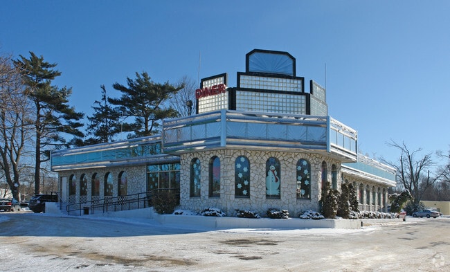
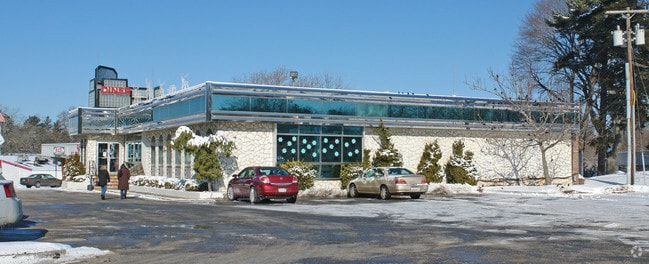
Property Record
579 Veterans Hwy, Hauppauge, NY 11788

NEARBY LISTINGS FOR SALE OR LEASE
Property Detail
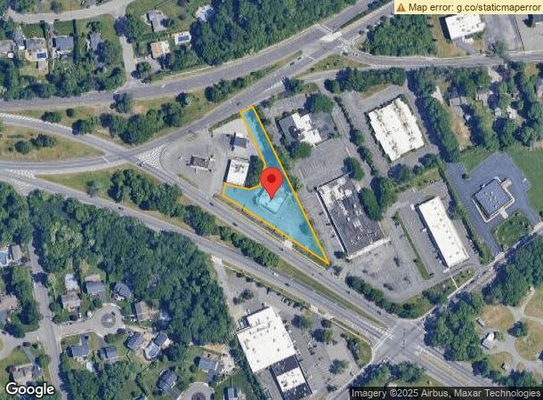
579 Veterans Hwy
Nassau County-Suffolk County, NY
X2218638Y218965 N001N00000000
0500-002-00-01-00-007-002
Suffolk
Restaurantbuilding
New York
X
100
36103C0655H
1.20 AC
0
Western Suffolk
2024
Long Island (New York)
145803
DEMOGRAPHICS near 579 Veterans Hwy
1 Mile
3 Mile
5 Mile
2024 Total Population
6,332
81,611
239,640
2029 Population
6,279
79,916
234,170
Pop Growth 2024-2029
(0.84%)
(2.08%)
(2.28%)
Average Age
42
40
40
2024 Total Households
2,232
24,015
70,769
HH Growth 2024-2029
(1.21%)
(2.19%)
(2.37%)
Median Household Inc
$122,694
$120,230
$123,487
Avg Household Size
2.80
3.20
3.20
2024 Avg HH Vehicles
2.00
2.00
2.00
Median Home Value
$669,323
$523,168
$491,617
Median Year Built
1966
1967
1967
Nearby Places
- Restaurants
- Banks
- Shops
- Fitness
- Groceries
PUBLIC TRANSPORTATION
COMMUTER RAIL
Central Islip Station (Ronkonkoma Branch - Long Island Rail Road)
DRIVE
WALK
Distance
Central Islip Station (Ronkonkoma Branch - Long Island Rail Road)
8 min
3.2 mi
Smithtown Station (Port Jefferson Branch - Long Island Rail Road)
DRIVE
WALK
Distance
Smithtown Station (Port Jefferson Branch - Long Island Rail Road)
7 min
3.7 mi
AIRPORT
Long Island MacArthur
DRIVE
WALK
Distance
Long Island MacArthur
15 min
7.9 mi
John F Kennedy International
DRIVE
WALK
Distance
John F Kennedy International
56 min
42.3 mi
Freight Ports
NY - Red Hook Container Terminal
DRIVE
WALK
Distance
NY - Red Hook Container Terminal
70 min
48.3 mi
SALE & LEASE HISTORY
LISTING DATE
SALE/LEASE

Jun 18, 2019
For Sale
Nearby Properties
Address
Land Use
TOTAL SIZE
Lot Size
Zoning
Address
Land Use
TOTAL SIZE
Lot Size
Zoning
301 SF
3.70 AC
Address
Land Use
TOTAL SIZE
Lot Size
Zoning
97.50 AC
AAA
Address
Land Use
TOTAL SIZE
Lot Size
Zoning
57.30 AC
AAA
Address
Land Use
TOTAL SIZE
Lot Size
Zoning
22.22 AC
AA
Address
Land Use
TOTAL SIZE
Lot Size
Zoning
8.05 AC
NULL
Address
Land Use
TOTAL SIZE
Lot Size
Zoning
170.87 AC
AAA
Address
Land Use
TOTAL SIZE
Lot Size
Zoning
24.10 AC
A
Address
Land Use
TOTAL SIZE
Lot Size
Zoning
2.79 AC
Address
Land Use
TOTAL SIZE
Lot Size
Zoning
36.66 AC
NULL
Address
Land Use
TOTAL SIZE
Lot Size
Zoning
24.96 AC
Address
Land Use
TOTAL SIZE
Lot Size
Zoning
24.70 AC
AAA
Address
Land Use
TOTAL SIZE
Lot Size
Zoning
13.06 AC
BUS3
Address
Land Use
TOTAL SIZE
Lot Size
Zoning
5,140 SF
23.39 AC
CA
Address
Land Use
TOTAL SIZE
Lot Size
Zoning
15 AC
AA
Address
Land Use
TOTAL SIZE
Lot Size
Zoning
45.56 AC
Address
Land Use
TOTAL SIZE
Lot Size
Zoning
12.84 AC
NULL
Address
Land Use
TOTAL SIZE
Lot Size
Zoning
8.02 AC
NULL
Address
Land Use
TOTAL SIZE
Lot Size
Zoning
10.90 AC
AAA
Address
Land Use
TOTAL SIZE
Lot Size
Zoning
22.84 AC
IND1
Address
Land Use
TOTAL SIZE
Lot Size
Zoning
45.71 AC
NULL
Address
Land Use
TOTAL SIZE
Lot Size
Zoning
10.50 AC
NULL
Address
Land Use
TOTAL SIZE
Lot Size
Zoning
5.32 AC
BUS3
Address
Land Use
TOTAL SIZE
Lot Size
Zoning
6.81 AC
NULL
Address
Land Use
TOTAL SIZE
Lot Size
Zoning
4,624 SF
9.73 AC
A
Address
Land Use
TOTAL SIZE
Lot Size
Zoning
12.80 AC
AAA
Address
Land Use
TOTAL SIZE
Lot Size
Zoning
8.35 AC
IND1
Address
Land Use
TOTAL SIZE
Lot Size
Zoning
32.59 AC
Address
Land Use
TOTAL SIZE
Lot Size
Zoning
3.98 AC
GSE
Address
Land Use
TOTAL SIZE
Lot Size
Zoning
9.90 AC
CA
Address
Land Use
TOTAL SIZE
Lot Size
Zoning
10.30 AC
CA
The World's #1 Commercial Real Estate Marketplace
Connect with us
© 2025 CoStar Group
The information above has been obtained from sources believed reliable. While we do not doubt its accuracy we have not verified it and make no guarantee, warranty or representation about it. It is your responsibility to independently confirm its accuracy and completeness. Any projections, opinions, assumptions, or estimates used are for example only and do not represent the current or future performance of the property. The value of this transaction to you depends on tax and other factors which should be evaluated by your tax, financial, and legal advisors. You and your advisors should conduct a careful, independent investigation of the property to determine to your satisfaction the suitability of the property for your needs.