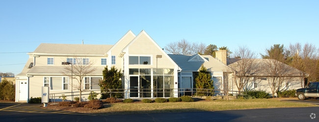
Property Record
5790 Post Rd, East Greenwich, RI 02818
NEARBY LISTINGS FOR SALE OR LEASE
Property Detail
5790 Post Rd
Commercialnec
Kent
X
Rhode Island
44009C0014J
2.53 AC
2025
East Greenwich
2025
Providence
020904
Providence-Warwick, RI-MA
3,241 SF
WARW-000214-000044-000000
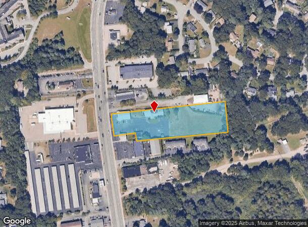
DEMOGRAPHICS near 5790 Post Rd
1 Mile
3 Mile
5 Mile
2024 Total Population
5,027
27,055
73,844
2029 Population
5,053
27,174
74,536
Pop Growth 2024-2029
+ 0.52%
+ 0.44%
+ 0.94%
Average Age
44
44
44
2024 Total Households
1,932
11,217
31,307
HH Growth 2024-2029
+ 0.05%
+ 0.18%
+ 0.85%
Median Household Inc
$107,834
$105,719
$84,581
Avg Household Size
2.50
2.30
2.30
2024 Avg HH Vehicles
2.00
2.00
2.00
Median Home Value
$448,347
$451,518
$373,672
Median Year Built
1965
1969
1971
Nearby Places
Map Layers
Map Styles
 Street
 Aerial
- Restaurants
- Banks
- Shops
- Fitness
- Groceries
PUBLIC TRANSPORTATION
AIRPORT
Rhode Island Tf Green International
DRIVE
WALK
Distance
Rhode Island Tf Green International
23 min
12.9 mi
SALE & LEASE HISTORY
LISTING DATE
SALE/LEASE

Sep 27, 2017
For Lease
Sep 25, 2016
For Lease
Jun 09, 2021
For Lease
Nearby Properties
Address
Land Use
TOTAL SIZE
Lot Size
Zoning
Address
Land Use
TOTAL SIZE
Lot Size
Zoning
122,785 SF
43.80 AC
QBPD
Address
Land Use
TOTAL SIZE
Lot Size
Zoning
19.60 AC
CH
Address
Land Use
TOTAL SIZE
Lot Size
Zoning
18,720 SF
15 AC
PDR
Address
Land Use
TOTAL SIZE
Lot Size
Zoning
83.30 AC
F1
Address
Land Use
TOTAL SIZE
Lot Size
Zoning
3,743 SF
A15
Address
Land Use
TOTAL SIZE
Lot Size
Zoning
20.43 AC
MUPD
Address
Land Use
TOTAL SIZE
Lot Size
Zoning
466,871 SF
17.96 AC
QBPD
Address
Land Use
TOTAL SIZE
Lot Size
Zoning
541,370 SF
34.08 AC
CI
Address
Land Use
TOTAL SIZE
Lot Size
Zoning
25,632 SF
A15
Address
Land Use
TOTAL SIZE
Lot Size
Zoning
10,375 SF
75.99 AC
A10
Address
Land Use
TOTAL SIZE
Lot Size
Zoning
19.65 AC
BP
Address
Land Use
TOTAL SIZE
Lot Size
Zoning
161,263 SF
61.75 AC
R30
Address
Land Use
TOTAL SIZE
Lot Size
Zoning
196,759 SF
33.67 AC
QBPD
Address
Land Use
TOTAL SIZE
Lot Size
Zoning
3,417 SF
7.13 AC
PR
Address
Land Use
TOTAL SIZE
Lot Size
Zoning
8.73 AC
PR
Address
Land Use
TOTAL SIZE
Lot Size
Zoning
63.69 AC
LI
Address
Land Use
TOTAL SIZE
Lot Size
Zoning
107,212 SF
18.50 AC
R10
Address
Land Use
TOTAL SIZE
Lot Size
Zoning
137,323 SF
22.84 AC
PR
Address
Land Use
TOTAL SIZE
Lot Size
Zoning
97,308 SF
9.36 AC
P
Address
Land Use
TOTAL SIZE
Lot Size
Zoning
5.31 AC
M/LI
Address
Land Use
TOTAL SIZE
Lot Size
Zoning
83.12 AC
MLIO
Address
Land Use
TOTAL SIZE
Lot Size
Zoning
9,216 SF
A7
Address
Land Use
TOTAL SIZE
Lot Size
Zoning
25.10 AC
QBPD
Address
Land Use
TOTAL SIZE
Lot Size
Zoning
12.68 AC
PR
Address
Land Use
TOTAL SIZE
Lot Size
Zoning
9.35 AC
PR
Address
Land Use
TOTAL SIZE
Lot Size
Zoning
8.85 AC
PR
Address
Land Use
TOTAL SIZE
Lot Size
Zoning
116,034 SF
10.65 AC
B
Address
Land Use
TOTAL SIZE
Lot Size
Zoning
15.90 AC
QBPD
Address
Land Use
TOTAL SIZE
Lot Size
Zoning
60,324 SF
4.39 AC
BP
Address
Land Use
TOTAL SIZE
Lot Size
Zoning
28.16 AC
B
The World's #1 Commercial Real Estate Marketplace
Connect with us
© 2025 CoStar Group
The information above has been obtained from sources believed reliable. While we do not doubt its accuracy we have not verified it and make no guarantee, warranty or representation about it. It is your responsibility to independently confirm its accuracy and completeness. Any projections, opinions, assumptions, or estimates used are for example only and do not represent the current or future performance of the property. The value of this transaction to you depends on tax and other factors which should be evaluated by your tax, financial, and legal advisors. You and your advisors should conduct a careful, independent investigation of the property to determine to your satisfaction the suitability of the property for your needs.