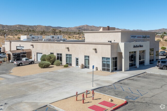
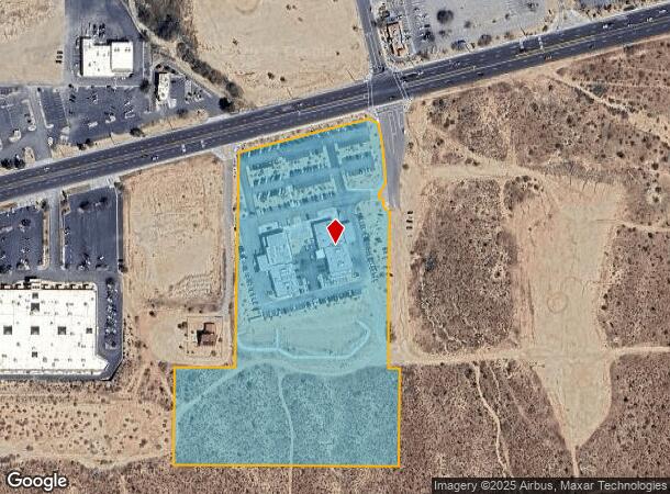
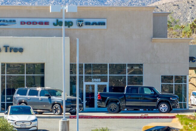
Property Record
57927 29 Palms Hwy, Yucca Valley, CA 92284
NEARBY LISTINGS FOR SALE OR LEASE
Property Detail
57927 29 Palms Hwy
0601-011-30
PTN W HALF OF SEC 31 TP 1N R 6E LYING S TWENTYNINE PALMS HIGHWAY DESC AS FOLLOWS COMMENCING AT THE C/L INTERSECTION SD TWENTYNINE PALMS HIGHWAY & HILTON AVE AS SD PT IS SHOWN ON PARCEL MAP 14239 PER MAP THEREOF RECORDED ON APRIL 23 1992 IN BK 166 PAR
Vehiclerentalsvehiclesales
San Bernardino
X
California
06071C8120H
11.37 AC
2024
Twentynine Palms
2025
Inland Empire (California)
010429
Riverside-San Bernardino-Ontario, CA
50,784 SF
DEMOGRAPHICS near 57927 29 Palms Hwy
1 Mile
3 Mile
5 Mile
2024 Total Population
3,566
20,828
30,316
2029 Population
3,660
21,481
31,352
Pop Growth 2024-2029
+ 2.64%
+ 3.14%
+ 3.42%
Average Age
40
42
42
2024 Total Households
1,394
8,328
12,427
HH Growth 2024-2029
+ 2.65%
+ 3.16%
+ 3.47%
Median Household Inc
$71,345
$63,387
$61,041
Avg Household Size
2.50
2.50
2.40
2024 Avg HH Vehicles
2.00
2.00
2.00
Median Home Value
$260,055
$278,100
$310,331
Median Year Built
1980
1980
1980
Nearby Places
Map Layers
Map Styles
 Street
 Aerial
- Restaurants
- Banks
- Shops
- Fitness
- Groceries
PUBLIC TRANSPORTATION
AIRPORT
Palm Springs International
DRIVE
WALK
Distance
Palm Springs International
45 min
32.4 mi
Freight Ports
Port of Long Beach
DRIVE
WALK
Distance
Port of Long Beach
157 min
124.3 mi
Nearby Properties
Address
Land Use
TOTAL SIZE
Lot Size
Zoning
Address
Land Use
TOTAL SIZE
Lot Size
Zoning
196,781 SF
23.85 AC
Address
Land Use
TOTAL SIZE
Lot Size
Zoning
102,500 SF
13.07 AC
Address
Land Use
TOTAL SIZE
Lot Size
Zoning
178,083 SF
1.75 AC
Address
Land Use
TOTAL SIZE
Lot Size
Zoning
51,455 SF
2.83 AC
Address
Land Use
TOTAL SIZE
Lot Size
Zoning
31,345 SF
10.12 AC
Address
Land Use
TOTAL SIZE
Lot Size
Zoning
81,904 SF
2 AC
Address
Land Use
TOTAL SIZE
Lot Size
Zoning
104,442 SF
7.29 AC
Address
Land Use
TOTAL SIZE
Lot Size
Zoning
17,299 SF
1.74 AC
Address
Land Use
TOTAL SIZE
Lot Size
Zoning
45,139 SF
3.67 AC
Address
Land Use
TOTAL SIZE
Lot Size
Zoning
19,950 SF
1.57 AC
Address
Land Use
TOTAL SIZE
Lot Size
Zoning
41,321 SF
1.83 AC
Address
Land Use
TOTAL SIZE
Lot Size
Zoning
89,981 SF
8.08 AC
Address
Land Use
TOTAL SIZE
Lot Size
Zoning
25,193 SF
2.72 AC
Address
Land Use
TOTAL SIZE
Lot Size
Zoning
30,393 SF
3.83 AC
Address
Land Use
TOTAL SIZE
Lot Size
Zoning
20,485 SF
2.39 AC
Address
Land Use
TOTAL SIZE
Lot Size
Zoning
10,399 SF
22.87 AC
Address
Land Use
TOTAL SIZE
Lot Size
Zoning
18,152 SF
5 AC
Address
Land Use
TOTAL SIZE
Lot Size
Zoning
14,285 SF
1.52 AC
Address
Land Use
TOTAL SIZE
Lot Size
Zoning
46,334 SF
2.20 AC
Address
Land Use
TOTAL SIZE
Lot Size
Zoning
52,500 SF
2.97 AC
926
Address
Land Use
TOTAL SIZE
Lot Size
Zoning
24,693 SF
2.31 AC
Address
Land Use
TOTAL SIZE
Lot Size
Zoning
7,668 SF
0.99 AC
Address
Land Use
TOTAL SIZE
Lot Size
Zoning
17,422 SF
2.40 AC
Address
Land Use
TOTAL SIZE
Lot Size
Zoning
32,900 SF
4.18 AC
Address
Land Use
TOTAL SIZE
Lot Size
Zoning
40,000 SF
3.03 AC
Address
Land Use
TOTAL SIZE
Lot Size
Zoning
18,124 SF
1.07 AC
Address
Land Use
TOTAL SIZE
Lot Size
Zoning
10,064 SF
0.88 AC
Address
Land Use
TOTAL SIZE
Lot Size
Zoning
49,282 SF
2.74 AC
Address
Land Use
TOTAL SIZE
Lot Size
Zoning
17,422 SF
2.36 AC
The World's #1 Commercial Real Estate Marketplace
Connect with us
© 2026 CoStar Group
The information above has been obtained from sources believed reliable. While we do not doubt its accuracy we have not verified it and make no guarantee, warranty or representation about it. It is your responsibility to independently confirm its accuracy and completeness. Any projections, opinions, assumptions, or estimates used are for example only and do not represent the current or future performance of the property. The value of this transaction to you depends on tax and other factors which should be evaluated by your tax, financial, and legal advisors. You and your advisors should conduct a careful, independent investigation of the property to determine to your satisfaction the suitability of the property for your needs.