Property Record
5794 Wagon Wheel Plz, Lakeside, AZ 85929

NEARBY LISTINGS FOR SALE OR LEASE
-
-
View all Lakeside listings for sale on LoopNet.com
Property Detail
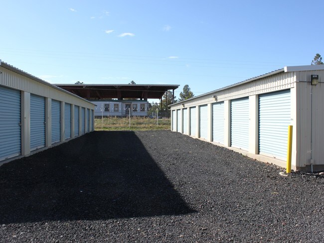
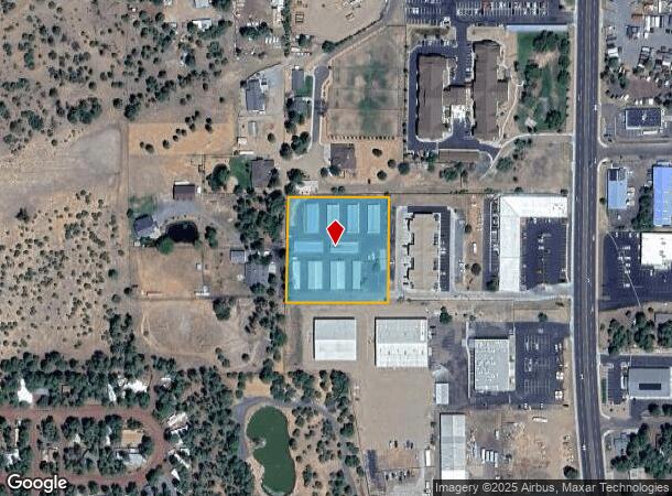
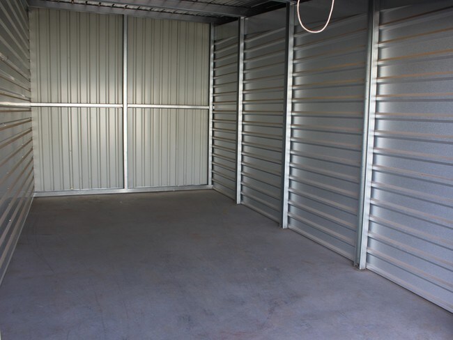
5794 Wagon Wheel Plz
212-07-024B
SECTION 9,T9N,R22E:W 300' OF..BEG S4 COR;TH N0DG14'W 2570.3'; THS89DG56'W 23';TH S0DG54'W ALG W R/W HWY 735' TPOB; TH S89DG56'W 830';TH S0DG54'W 312' ; THN89DG56'E 830';TH N0DG54'E 312' ALG W R/W, TPOB /
Shipyard
Navajo
X
Arizona
04017C4709F
2.15 AC
2024
Arizona Northeast & Holbrook Area
2026
Other Market Areas
961300
Show Low, AZ
24,000 SF
DEMOGRAPHICS near 5794 Wagon Wheel Plz
1 Mile
3 Mile
5 Mile
2024 Total Population
2,741
8,855
20,681
2029 Population
3,028
9,627
22,360
Pop Growth 2024-2029
+ 10.47%
+ 8.72%
+ 8.12%
Average Age
45
45
43
2024 Total Households
1,093
3,519
8,416
HH Growth 2024-2029
+ 10.43%
+ 8.55%
+ 7.98%
Median Household Inc
$43,474
$52,180
$53,958
Avg Household Size
2.40
2.40
2.40
2024 Avg HH Vehicles
2.00
2.00
2.00
Median Home Value
$224,893
$231,334
$216,388
Median Year Built
1997
1995
1993
Nearby Places
Map Layers
Map Styles
 Street
 Aerial
- Restaurants
- Banks
- Shops
- Fitness
- Groceries
SALE & LEASE HISTORY
LISTING DATE
SALE/LEASE

Apr 07, 2019
For Sale
Nearby Properties
Address
Land Use
TOTAL SIZE
Lot Size
Zoning
Address
Land Use
TOTAL SIZE
Lot Size
Zoning
203,623 SF
14 AC
MUNICIPAL
Address
Land Use
TOTAL SIZE
Lot Size
Zoning
138,315 SF
13.91 AC
MUNICIPAL
Address
Land Use
TOTAL SIZE
Lot Size
Zoning
55,688 SF
1.50 AC
C-R
Address
Land Use
TOTAL SIZE
Lot Size
Zoning
83,087 SF
5.08 AC
MUNICIPAL
Address
Land Use
TOTAL SIZE
Lot Size
Zoning
56,096 SF
1.48 AC
C-R
Address
Land Use
TOTAL SIZE
Lot Size
Zoning
56,331 SF
16.30 AC
MUNICIPAL
Address
Land Use
TOTAL SIZE
Lot Size
Zoning
44,764 SF
1.51 AC
MUNICIPAL
Address
Land Use
TOTAL SIZE
Lot Size
Zoning
97,790 SF
4.80 AC
MUNICIPAL
Address
Land Use
TOTAL SIZE
Lot Size
Zoning
86,443 SF
6.85 AC
MUNICIPAL
Address
Land Use
TOTAL SIZE
Lot Size
Zoning
26,530 SF
3.88 AC
C-R
Address
Land Use
TOTAL SIZE
Lot Size
Zoning
22,680 SF
1.65 AC
C-R
Address
Land Use
TOTAL SIZE
Lot Size
Zoning
42,868 SF
2.45 AC
MUNICIPAL
Address
Land Use
TOTAL SIZE
Lot Size
Zoning
48,320 SF
5 AC
C-R
Address
Land Use
TOTAL SIZE
Lot Size
Zoning
47,586 SF
3.50 AC
MUNICIPAL
Address
Land Use
TOTAL SIZE
Lot Size
Zoning
22,400 SF
2.55 AC
MUNICIPAL
Address
Land Use
TOTAL SIZE
Lot Size
Zoning
35,090 SF
3.40 AC
MUNICIPAL
Address
Land Use
TOTAL SIZE
Lot Size
Zoning
20,088 SF
2 AC
R-2
Address
Land Use
TOTAL SIZE
Lot Size
Zoning
16,157 SF
4.56 AC
R1-10
Address
Land Use
TOTAL SIZE
Lot Size
Zoning
46,318 SF
20 AC
MUNICIPAL
Address
Land Use
TOTAL SIZE
Lot Size
Zoning
18,000 SF
2.09 AC
MUNICIPAL
Address
Land Use
TOTAL SIZE
Lot Size
Zoning
28,700 SF
2.76 AC
MUNICIPAL
Address
Land Use
TOTAL SIZE
Lot Size
Zoning
22,705 SF
3.74 AC
MUNICIPAL
Address
Land Use
TOTAL SIZE
Lot Size
Zoning
15,073 SF
3.36 AC
MUNICIPAL
Address
Land Use
TOTAL SIZE
Lot Size
Zoning
21,333 SF
2.14 AC
C-R
Address
Land Use
TOTAL SIZE
Lot Size
Zoning
22,400 SF
2.01 AC
MUNICIPAL
Address
Land Use
TOTAL SIZE
Lot Size
Zoning
7,328 SF
1.82 AC
MUNICIPAL
Address
Land Use
TOTAL SIZE
Lot Size
Zoning
16,689 SF
1 AC
MUNICIPAL
Address
Land Use
TOTAL SIZE
Lot Size
Zoning
17,925 SF
1.99 AC
MUNICIPAL
Address
Land Use
TOTAL SIZE
Lot Size
Zoning
48,506 SF
3.08 AC
C-R
The World's #1 Commercial Real Estate Marketplace
Connect with us
© 2025 CoStar Group
The information above has been obtained from sources believed reliable. While we do not doubt its accuracy we have not verified it and make no guarantee, warranty or representation about it. It is your responsibility to independently confirm its accuracy and completeness. Any projections, opinions, assumptions, or estimates used are for example only and do not represent the current or future performance of the property. The value of this transaction to you depends on tax and other factors which should be evaluated by your tax, financial, and legal advisors. You and your advisors should conduct a careful, independent investigation of the property to determine to your satisfaction the suitability of the property for your needs.