Property Record
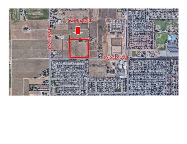
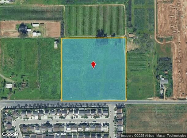
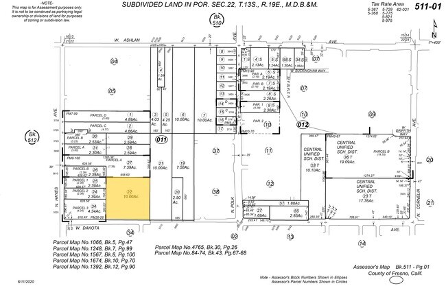
5796 W Dakota Ave, Fresno, CA 93722
NEARBY LISTINGS FOR SALE OR LEASE
Property Detail
5796 W Dakota Ave
Fresno, CA
Fresno
511-011-22
California
Sfr
9.88 AC
X
West Fresno
06019C1545H
Fresno
928 SF
DEMOGRAPHICS near 5796 W Dakota Ave
1 Mile
3 Mile
5 Mile
2024 Total Population
10,924
85,512
182,206
2029 Population
11,311
87,718
186,112
Pop Growth 2024-2029
+ 3.54%
+ 2.58%
+ 2.14%
Average Age
35
35
36
2024 Total Households
2,970
25,899
59,730
HH Growth 2024-2029
+ 3.67%
+ 2.62%
+ 2.13%
Median Household Inc
$84,625
$70,403
$68,594
Avg Household Size
3.50
3.20
3.00
2024 Avg HH Vehicles
3.00
2.00
2.00
Median Home Value
$332,349
$305,843
$327,602
Median Year Built
1995
1994
1983
Nearby Places
Map Layers
Map Styles
 Street
 Aerial
- Restaurants
- Banks
- Shops
- Fitness
- Groceries
PUBLIC TRANSPORTATION
COMMUTER RAIL
DRIVE
WALK
Distance
14 min
9.2 mi
AIRPORT
Fresno Yosemite International
DRIVE
WALK
Distance
Fresno Yosemite International
20 min
10.9 mi
SALE & LEASE HISTORY
LISTING DATE
SALE/LEASE

Feb 19, 2021
For Sale
Nearby Properties
Address
Land Use
TOTAL SIZE
Lot Size
Zoning
Address
Land Use
TOTAL SIZE
Lot Size
Zoning
477,820 SF
18.78 AC
RA
Address
Land Use
TOTAL SIZE
Lot Size
Zoning
412,974 SF
29.02 AC
R2
Address
Land Use
TOTAL SIZE
Lot Size
Zoning
197,659 SF
11.80 AC
CC
Address
Land Use
TOTAL SIZE
Lot Size
Zoning
423,568 SF
32.25 AC
R2
Address
Land Use
TOTAL SIZE
Lot Size
Zoning
178,900 SF
11.68 AC
CP
Address
Land Use
TOTAL SIZE
Lot Size
Zoning
232,183 SF
18.32 AC
R2A
Address
Land Use
TOTAL SIZE
Lot Size
Zoning
176,228 SF
10.17 AC
R2
Address
Land Use
TOTAL SIZE
Lot Size
Zoning
83,026 SF
5.02 AC
RM1
Address
Land Use
TOTAL SIZE
Lot Size
Zoning
92,279 SF
0.01 AC
CM
Address
Land Use
TOTAL SIZE
Lot Size
Zoning
159,822 SF
9.67 AC
R2
Address
Land Use
TOTAL SIZE
Lot Size
Zoning
51,363 SF
3.14 AC
CG
Address
Land Use
TOTAL SIZE
Lot Size
Zoning
45,226 SF
2.77 AC
C2
Address
Land Use
TOTAL SIZE
Lot Size
Zoning
145,783 SF
9.22 AC
R2
Address
Land Use
TOTAL SIZE
Lot Size
Zoning
111,149 SF
8.22 AC
RM1
Address
Land Use
TOTAL SIZE
Lot Size
Zoning
128,386 SF
8.30 AC
R2
Address
Land Use
TOTAL SIZE
Lot Size
Zoning
111,285 SF
10 AC
R1
Address
Land Use
TOTAL SIZE
Lot Size
Zoning
182,722 SF
13.29 AC
R2
Address
Land Use
TOTAL SIZE
Lot Size
Zoning
55,200 SF
3.73 AC
RM1
Address
Land Use
TOTAL SIZE
Lot Size
Zoning
207,808 SF
17.59 AC
CM
Address
Land Use
TOTAL SIZE
Lot Size
Zoning
79,563 SF
5.72 AC
CR
Address
Land Use
TOTAL SIZE
Lot Size
Zoning
56,490 SF
1.93 AC
CP
Address
Land Use
TOTAL SIZE
Lot Size
Zoning
127,394 SF
8.87 AC
R2
Address
Land Use
TOTAL SIZE
Lot Size
Zoning
96,077 SF
8.29 AC
C3
Address
Land Use
TOTAL SIZE
Lot Size
Zoning
132,690 SF
7.86 AC
RA
Address
Land Use
TOTAL SIZE
Lot Size
Zoning
108,795 SF
7.32 AC
R2
Address
Land Use
TOTAL SIZE
Lot Size
Zoning
64,428 SF
1.80 AC
CP
Address
Land Use
TOTAL SIZE
Lot Size
Zoning
102,160 SF
8.45 AC
SPLIT
Address
Land Use
TOTAL SIZE
Lot Size
Zoning
84,050 SF
6.84 AC
R3
Address
Land Use
TOTAL SIZE
Lot Size
Zoning
111,104 SF
7.96 AC
R2A
Address
Land Use
TOTAL SIZE
Lot Size
Zoning
96,760 SF
11.11 AC
SPLIT
The World's #1 Commercial Real Estate Marketplace
Connect with us
© 2025 CoStar Group
The information above has been obtained from sources believed reliable. While we do not doubt its accuracy we have not verified it and make no guarantee, warranty or representation about it. It is your responsibility to independently confirm its accuracy and completeness. Any projections, opinions, assumptions, or estimates used are for example only and do not represent the current or future performance of the property. The value of this transaction to you depends on tax and other factors which should be evaluated by your tax, financial, and legal advisors. You and your advisors should conduct a careful, independent investigation of the property to determine to your satisfaction the suitability of the property for your needs.