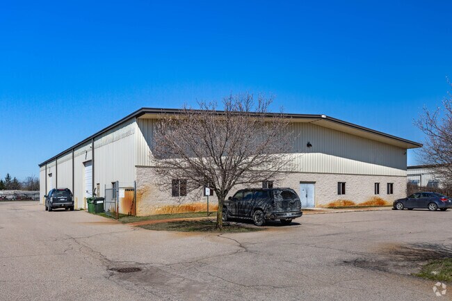
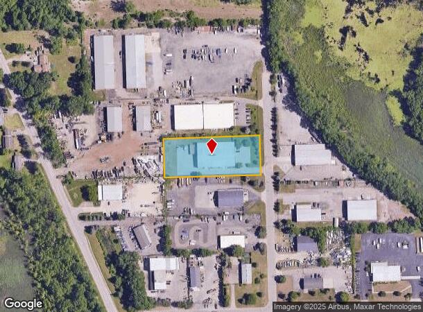
Property Record
5799 Terex, Clarkston, MI 48346
NEARBY LISTINGS FOR SALE OR LEASE
Property Detail
5799 Terex
Detroit-Warren-Dearborn, MI
Valentines Industrial Plat
07-26-326-035
T4N, R8E, SEC 26 VALENTINE'S INDUSTRIAL PLAT LOT 23 10-7-03 FR 032
Warehouse
Oakland
X
Michigan
26125C0330F
10,23
2024
1.49 AC
2025
Lakes Area
126400
Detroit
15,000 SF
DEMOGRAPHICS near 5799 Terex
1 Mile
3 Mile
5 Mile
2024 Total Population
1,118
13,242
54,811
2029 Population
1,102
13,145
54,246
Pop Growth 2024-2029
(1.43%)
(0.73%)
(1.03%)
Average Age
42
43
43
2024 Total Households
377
5,063
21,529
HH Growth 2024-2029
(1.33%)
(0.83%)
(1.09%)
Median Household Inc
$116,145
$108,824
$94,479
Avg Household Size
2.90
2.60
2.50
2024 Avg HH Vehicles
2.00
2.00
2.00
Median Home Value
$299,999
$355,175
$302,278
Median Year Built
1980
1985
1980
Nearby Places
Map Layers
Map Styles
 Street
 Aerial
- Restaurants
- Banks
- Shops
- Fitness
- Groceries
PUBLIC TRANSPORTATION
AIRPORT
Bishop International
DRIVE
WALK
Distance
Bishop International
48 min
31.3 mi
Nearby Properties
Address
Land Use
TOTAL SIZE
Lot Size
Zoning
Address
Land Use
TOTAL SIZE
Lot Size
Zoning
68,725 SF
4.96 AC
PUD
Address
Land Use
TOTAL SIZE
Lot Size
Zoning
21,719 SF
26.34 AC
R2
Address
Land Use
TOTAL SIZE
Lot Size
Zoning
78,261 SF
7.80 AC
PUD
Address
Land Use
TOTAL SIZE
Lot Size
Zoning
44.10 AC
PUD
Address
Land Use
TOTAL SIZE
Lot Size
Zoning
327,288 SF
29.09 AC
REC
Address
Land Use
TOTAL SIZE
Lot Size
Zoning
19,504 SF
3.16 AC
ML
Address
Land Use
TOTAL SIZE
Lot Size
Zoning
151,736 SF
26.03 AC
C-2
Address
Land Use
TOTAL SIZE
Lot Size
Zoning
32,059 SF
BLL
Address
Land Use
TOTAL SIZE
Lot Size
Zoning
143,550 SF
11.92 AC
R2
Address
Land Use
TOTAL SIZE
Lot Size
Zoning
739 SF
5.36 AC
R1A
Address
Land Use
TOTAL SIZE
Lot Size
Zoning
82,864 SF
30.65 AC
MH
Address
Land Use
TOTAL SIZE
Lot Size
Zoning
34,111 SF
20.14 AC
Address
Land Use
TOTAL SIZE
Lot Size
Zoning
30,726 SF
3.44 AC
R3
Address
Land Use
TOTAL SIZE
Lot Size
Zoning
80,974 SF
8.37 AC
C-3
Address
Land Use
TOTAL SIZE
Lot Size
Zoning
26,221 SF
15.76 AC
C2
Address
Land Use
TOTAL SIZE
Lot Size
Zoning
30,711 SF
3.17 AC
PUD
Address
Land Use
TOTAL SIZE
Lot Size
Zoning
261,633 SF
1,321.20 AC
C2GEN
Address
Land Use
TOTAL SIZE
Lot Size
Zoning
44,258 SF
8.86 AC
C2GEN
Address
Land Use
TOTAL SIZE
Lot Size
Zoning
40,909 SF
3.73 AC
AI
Address
Land Use
TOTAL SIZE
Lot Size
Zoning
28.31 AC
R1C
Address
Land Use
TOTAL SIZE
Lot Size
Zoning
60,709 SF
93.25 AC
Address
Land Use
TOTAL SIZE
Lot Size
Zoning
34.16 AC
PUD
Address
Land Use
TOTAL SIZE
Lot Size
Zoning
59,491 SF
6.94 AC
C2GEN
Address
Land Use
TOTAL SIZE
Lot Size
Zoning
74,592 SF
8.05 AC
RMMULT
Address
Land Use
TOTAL SIZE
Lot Size
Zoning
32,400 SF
3.43 AC
ML
Address
Land Use
TOTAL SIZE
Lot Size
Zoning
30,082 SF
3.39 AC
C-2
Address
Land Use
TOTAL SIZE
Lot Size
Zoning
64,583 SF
9.25 AC
M1
Address
Land Use
TOTAL SIZE
Lot Size
Zoning
22,120 SF
2.36 AC
PUD
Address
Land Use
TOTAL SIZE
Lot Size
Zoning
13,880 SF
2.72 AC
C-3
Address
Land Use
TOTAL SIZE
Lot Size
Zoning
46,820 SF
54.70 AC
The World's #1 Commercial Real Estate Marketplace
Connect with us
© 2026 CoStar Group
The information above has been obtained from sources believed reliable. While we do not doubt its accuracy we have not verified it and make no guarantee, warranty or representation about it. It is your responsibility to independently confirm its accuracy and completeness. Any projections, opinions, assumptions, or estimates used are for example only and do not represent the current or future performance of the property. The value of this transaction to you depends on tax and other factors which should be evaluated by your tax, financial, and legal advisors. You and your advisors should conduct a careful, independent investigation of the property to determine to your satisfaction the suitability of the property for your needs.