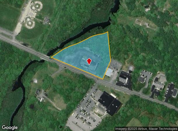
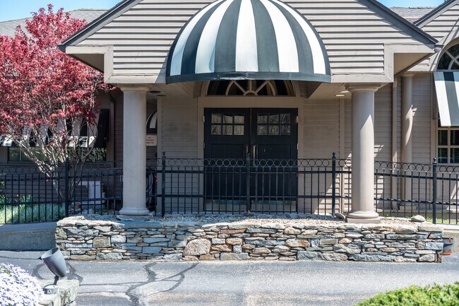
Property Record
58 E Grove St, Middleboro, MA 02346

NEARBY LISTINGS FOR SALE OR LEASE
Property Detail
58 E Grove St
MIDD-000058-005557
Plymouth
Restaurantbuilding
Massachusetts
AE
5557
25023C0318K
2 AC
2025
Route 3 South
2025
Boston
542200
Boston-Cambridge-Newton, MA-NH
9,633 SF
DEMOGRAPHICS near 58 E Grove St
1 Mile
3 Mile
5 Mile
2024 Total Population
5,910
16,730
30,997
2029 Population
5,893
16,784
31,164
Pop Growth 2024-2029
(0.29%)
+ 0.32%
+ 0.54%
Average Age
40
41
43
2024 Total Households
2,370
6,553
11,915
HH Growth 2024-2029
(0.38%)
+ 0.23%
+ 0.45%
Median Household Inc
$74,964
$81,320
$87,219
Avg Household Size
2.40
2.50
2.50
2024 Avg HH Vehicles
2.00
2.00
2.00
Median Home Value
$383,561
$408,975
$418,013
Median Year Built
1959
1970
1979
Nearby Places
Map Layers
Map Styles
 Street
 Aerial
- Restaurants
- Banks
- Shops
- Fitness
- Groceries
PUBLIC TRANSPORTATION
COMMUTER RAIL
Middleborough/Lakeville (Middleborough/Lakeville Line - Massachusetts Bay Transportation Authority Commuter Rail (Purple Line))
DRIVE
WALK
Distance
Middleborough/Lakeville (Middleborough/Lakeville Line - Massachusetts Bay Transportation Authority Commuter Rail (Purple Line))
4 min
1.6 mi
AIRPORT
Rhode Island Tf Green International
DRIVE
WALK
Distance
Rhode Island Tf Green International
61 min
35.5 mi
General Edward Lawrence Logan International
DRIVE
WALK
Distance
General Edward Lawrence Logan International
58 min
42.5 mi
Freight Ports
Port of New Bedford Harbor
DRIVE
WALK
Distance
Port of New Bedford Harbor
34 min
21.1 mi
Nearby Properties
Address
Land Use
TOTAL SIZE
Lot Size
Zoning
Address
Land Use
TOTAL SIZE
Lot Size
Zoning
34.41 AC
Address
Land Use
TOTAL SIZE
Lot Size
Zoning
167,715 SF
29.54 AC
Address
Land Use
TOTAL SIZE
Lot Size
Zoning
144,454 SF
66.89 AC
Address
Land Use
TOTAL SIZE
Lot Size
Zoning
575,572 SF
119.44 AC
Address
Land Use
TOTAL SIZE
Lot Size
Zoning
38.61 AC
Address
Land Use
TOTAL SIZE
Lot Size
Zoning
173,003 SF
26.10 AC
Address
Land Use
TOTAL SIZE
Lot Size
Zoning
2.30 AC
Address
Land Use
TOTAL SIZE
Lot Size
Zoning
7.41 AC
Address
Land Use
TOTAL SIZE
Lot Size
Zoning
48.30 AC
Address
Land Use
TOTAL SIZE
Lot Size
Zoning
108,990 SF
6.18 AC
Address
Land Use
TOTAL SIZE
Lot Size
Zoning
130,582 SF
23.41 AC
Address
Land Use
TOTAL SIZE
Lot Size
Zoning
64,023 SF
3.48 AC
Address
Land Use
TOTAL SIZE
Lot Size
Zoning
128,922 SF
12.50 AC
Address
Land Use
TOTAL SIZE
Lot Size
Zoning
7.33 AC
Address
Land Use
TOTAL SIZE
Lot Size
Zoning
36.10 AC
Address
Land Use
TOTAL SIZE
Lot Size
Zoning
20.37 AC
Address
Land Use
TOTAL SIZE
Lot Size
Zoning
159,630 SF
10.91 AC
Address
Land Use
TOTAL SIZE
Lot Size
Zoning
89,979 SF
18.52 AC
Address
Land Use
TOTAL SIZE
Lot Size
Zoning
15,663 SF
8.50 AC
Address
Land Use
TOTAL SIZE
Lot Size
Zoning
10,779 SF
1.53 AC
Address
Land Use
TOTAL SIZE
Lot Size
Zoning
5,792 SF
22.04 AC
Address
Land Use
TOTAL SIZE
Lot Size
Zoning
3.05 AC
Address
Land Use
TOTAL SIZE
Lot Size
Zoning
2.68 AC
Address
Land Use
TOTAL SIZE
Lot Size
Zoning
35,805 SF
4.18 AC
Address
Land Use
TOTAL SIZE
Lot Size
Zoning
67,224 SF
4.04 AC
Address
Land Use
TOTAL SIZE
Lot Size
Zoning
54,800 SF
3.26 AC
Address
Land Use
TOTAL SIZE
Lot Size
Zoning
52,152 SF
12 AC
Address
Land Use
TOTAL SIZE
Lot Size
Zoning
38,744 SF
8.50 AC
Address
Land Use
TOTAL SIZE
Lot Size
Zoning
85,000 SF
13.07 AC
Address
Land Use
TOTAL SIZE
Lot Size
Zoning
72,045 SF
3.12 AC
The World's #1 Commercial Real Estate Marketplace
Connect with us
© 2026 CoStar Group
The information above has been obtained from sources believed reliable. While we do not doubt its accuracy we have not verified it and make no guarantee, warranty or representation about it. It is your responsibility to independently confirm its accuracy and completeness. Any projections, opinions, assumptions, or estimates used are for example only and do not represent the current or future performance of the property. The value of this transaction to you depends on tax and other factors which should be evaluated by your tax, financial, and legal advisors. You and your advisors should conduct a careful, independent investigation of the property to determine to your satisfaction the suitability of the property for your needs.