Property Record
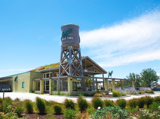
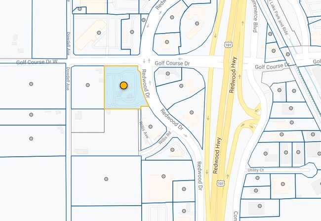
58 Golf Course Dr W, Rohnert Park, CA 94928

NEARBY LISTINGS FOR SALE OR LEASE
Property Detail
58 Golf Course Dr W
045-075-019
Santa Rosa Farms No 2
Restaurantdrivein
2016 FM 045-075-018 & 045-082-053 MERGER RP
X
Sonoma
06097C0877F
California
2024
2.24 AC
2025
Santa Rosa
151206
North Bay/Santa Rosa
4,288 SF
Santa Rosa, CA
DEMOGRAPHICS near 58 Golf Course Dr W
1 Mile
3 Mile
5 Mile
2024 Total Population
4,468
61,546
117,694
2029 Population
4,441
61,039
116,363
Pop Growth 2024-2029
(0.60%)
(0.82%)
(1.13%)
Average Age
40
39
39
2024 Total Households
1,642
22,879
41,189
HH Growth 2024-2029
(0.61%)
(0.84%)
(1.18%)
Median Household Inc
$101,468
$84,889
$84,812
Avg Household Size
2.70
2.60
2.80
2024 Avg HH Vehicles
2.00
2.00
2.00
Median Home Value
$683,134
$662,964
$686,716
Median Year Built
1982
1981
1983
Nearby Places
Map Layers
Map Styles
 Street
 Aerial
- Restaurants
- Banks
- Shops
- Fitness
- Groceries
PUBLIC TRANSPORTATION
COMMUTER RAIL
DRIVE
WALK
Distance
5 min
2.0 mi
DRIVE
WALK
Distance
8 min
3.9 mi
AIRPORT
Charles M Schulz - Sonoma County
DRIVE
WALK
Distance
Charles M Schulz - Sonoma County
19 min
13.7 mi
SALE & LEASE HISTORY
LISTING DATE
SALE/LEASE

Jan 07, 2020
For Sale
Nearby Properties
Address
Land Use
TOTAL SIZE
Lot Size
Zoning
Address
Land Use
TOTAL SIZE
Lot Size
Zoning
295,383 SF
12.30 AC
Address
Land Use
TOTAL SIZE
Lot Size
Zoning
287,036 SF
11.09 AC
MLPD
Address
Land Use
TOTAL SIZE
Lot Size
Zoning
123,512 SF
15.83 AC
CITYRP
Address
Land Use
TOTAL SIZE
Lot Size
Zoning
184,186 SF
6 AC
MLPD
Address
Land Use
TOTAL SIZE
Lot Size
Zoning
270,526 SF
8.08 AC
Address
Land Use
TOTAL SIZE
Lot Size
Zoning
194,396 SF
7.36 AC
Address
Land Use
TOTAL SIZE
Lot Size
Zoning
10.30 AC
Address
Land Use
TOTAL SIZE
Lot Size
Zoning
187,024 SF
8.64 AC
Address
Land Use
TOTAL SIZE
Lot Size
Zoning
229,265 SF
3.03 AC
RM
Address
Land Use
TOTAL SIZE
Lot Size
Zoning
91,624 SF
4.94 AC
CITYRP
Address
Land Use
TOTAL SIZE
Lot Size
Zoning
180,934 SF
5.55 AC
CITYRP
Address
Land Use
TOTAL SIZE
Lot Size
Zoning
7,370 SF
4.85 AC
M3
Address
Land Use
TOTAL SIZE
Lot Size
Zoning
213,331 SF
12.53 AC
CREC
Address
Land Use
TOTAL SIZE
Lot Size
Zoning
165,408 SF
5.40 AC
MLPD
Address
Land Use
TOTAL SIZE
Lot Size
Zoning
149,007 SF
0.25 AC
M1RP
Address
Land Use
TOTAL SIZE
Lot Size
Zoning
49,077 SF
7.09 AC
R210
Address
Land Use
TOTAL SIZE
Lot Size
Zoning
90,585 SF
2.28 AC
Address
Land Use
TOTAL SIZE
Lot Size
Zoning
142,759 SF
13.15 AC
CRPD
Address
Land Use
TOTAL SIZE
Lot Size
Zoning
87,286 SF
3.03 AC
Address
Land Use
TOTAL SIZE
Lot Size
Zoning
61,880 SF
2.53 AC
Address
Land Use
TOTAL SIZE
Lot Size
Zoning
107,599 SF
2.98 AC
Address
Land Use
TOTAL SIZE
Lot Size
Zoning
67,584 SF
4.79 AC
CITYRP
Address
Land Use
TOTAL SIZE
Lot Size
Zoning
144,198 SF
12.08 AC
CRPD
Address
Land Use
TOTAL SIZE
Lot Size
Zoning
3.33 AC
MLPD
Address
Land Use
TOTAL SIZE
Lot Size
Zoning
50,880 SF
4.77 AC
CITYRP
Address
Land Use
TOTAL SIZE
Lot Size
Zoning
77,660 SF
2.09 AC
CITYRP
Address
Land Use
TOTAL SIZE
Lot Size
Zoning
138,134 SF
12.54 AC
C1
Address
Land Use
TOTAL SIZE
Lot Size
Zoning
3,720 SF
4.11 AC
C2
Address
Land Use
TOTAL SIZE
Lot Size
Zoning
85,844 SF
2.34 AC
MLPD
Address
Land Use
TOTAL SIZE
Lot Size
Zoning
55,387 SF
3.07 AC
CITYRP
The World's #1 Commercial Real Estate Marketplace
Connect with us
© 2025 CoStar Group
The information above has been obtained from sources believed reliable. While we do not doubt its accuracy we have not verified it and make no guarantee, warranty or representation about it. It is your responsibility to independently confirm its accuracy and completeness. Any projections, opinions, assumptions, or estimates used are for example only and do not represent the current or future performance of the property. The value of this transaction to you depends on tax and other factors which should be evaluated by your tax, financial, and legal advisors. You and your advisors should conduct a careful, independent investigation of the property to determine to your satisfaction the suitability of the property for your needs.