Property Record
58 Locust Ave, Bloomfield, NJ 07003
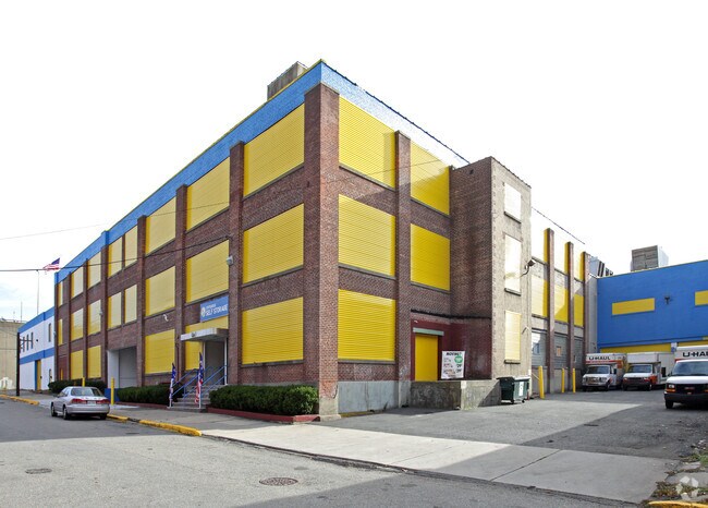


Property Detail
58 Locust Ave
02-00129-0000-00060
1.923 AC.
Warehouse
Essex
M-1
New Jersey
AE The base floodplain where base flood elevations are provided. AE Zones are now used on new format FIRMs instead of A1-A30 Zones.
60
2024
1.92 AC
2025
Bloomfield/GSP
015600
Northern New Jersey
152,402 SF
Newark, NJ
NEARBY LISTINGS FOR SALE OR LEASE
DEMOGRAPHICS near 58 Locust Ave
1 mile
3 mile
5 mile
2025 Total Population
37,861
370,852
811,590
2030 Population
39,470
384,906
841,393
Pop Growth 2025-2030
+ 4.25%
+ 3.79%
+ 3.67%
Average Age
40
39
39
2025 Total Households
14,928
140,088
302,355
HH Growth 2025-2030
+ 4.58%
+ 4.09%
+ 3.96%
Median Household Inc
$91,115
$72,170
$76,586
Avg Household Size
2.40
2.50
2.60
2025 Avg HH Vehicles
1.00
1.00
1.00
Median Home Value
$444,197
$435,876
$472,467
Median Year Built
1949
1955
1957
Nearby Places
Map Layers
Map Styles
 Street
 Aerial
Layers
 Traffic
 Biking
Places
Listings with unknown addresses are not visible on the map
- Restaurants
- Banks
- Shops
- Fitness
- Groceries
PUBLIC TRANSPORTATION
TRANSIT/SUBWAY
Grove Street (Grove Street - Newark Penn Station - Newark Light Rail (Newark Light Rail))
Drive
Walk
Distance
Grove Street (Grove Street - Newark Penn Station - Newark Light Rail (Newark Light Rail))
3 min
20 min
1.0 mi
COMMUTER RAIL
Watsessing Avenue (Montclair-Boonton Line - NJ Transit Commuter Rail (NJ Transit))
Drive
Walk
Distance
Watsessing Avenue (Montclair-Boonton Line - NJ Transit Commuter Rail (NJ Transit))
1 min
7 min
0.4 mi
Bloomfield (Montclair-Boonton Line - NJ Transit Commuter Rail (NJ Transit))
Drive
Walk
Distance
Bloomfield (Montclair-Boonton Line - NJ Transit Commuter Rail (NJ Transit))
2 min
14 min
0.8 mi
AIRPORT
Newark Liberty International
Drive
Walk
Distance
Newark Liberty International
16 min
9.5 mi
LaGuardia
Drive
Walk
Distance
LaGuardia
45 min
26.2 mi
John F Kennedy International
Drive
Walk
Distance
John F Kennedy International
53 min
34.2 mi
Freight Ports
Port Newark Container Terminal
Drive
Walk
Distance
Port Newark Container Terminal
19 min
9.5 mi
Nearby Properties
Address
Land Use
TOTAL SIZE
Lot Size
Zoning
Address
Land Use
TOTAL SIZE
Lot Size
Zoning
0.57 AC
Address
Land Use
TOTAL SIZE
Lot Size
Zoning
926,120 SF
11.46 AC
Address
Land Use
TOTAL SIZE
Lot Size
Zoning
33.60 AC
P-C
Address
Land Use
TOTAL SIZE
Lot Size
Zoning
5 AC
H
Address
Land Use
TOTAL SIZE
Lot Size
Zoning
17.97 AC
Address
Land Use
TOTAL SIZE
Lot Size
Zoning
Address
Land Use
TOTAL SIZE
Lot Size
Zoning
0.13 AC
Address
Land Use
TOTAL SIZE
Lot Size
Zoning
16,084 SF
7.23 AC
Address
Land Use
TOTAL SIZE
Lot Size
Zoning
1,589 SF
0.22 AC
R4
Address
Land Use
TOTAL SIZE
Lot Size
Zoning
12.54 AC
OPRP
Address
Land Use
TOTAL SIZE
Lot Size
Zoning
3.31 AC
Address
Land Use
TOTAL SIZE
Lot Size
Zoning
0.24 AC
R4
Address
Land Use
TOTAL SIZE
Lot Size
Zoning
2.64 AC
Address
Land Use
TOTAL SIZE
Lot Size
Zoning
4.92 AC
Address
Land Use
TOTAL SIZE
Lot Size
Zoning
Address
Land Use
TOTAL SIZE
Lot Size
Zoning
4.33 AC
Address
Land Use
TOTAL SIZE
Lot Size
Zoning
11.49 AC
M-1
Address
Land Use
TOTAL SIZE
Lot Size
Zoning
298,272 SF
31.36 AC
P-6
Address
Land Use
TOTAL SIZE
Lot Size
Zoning
7.03 AC
Address
Land Use
TOTAL SIZE
Lot Size
Zoning
306,414 SF
4.62 AC
Address
Land Use
TOTAL SIZE
Lot Size
Zoning
3.26 AC
PR
Address
Land Use
TOTAL SIZE
Lot Size
Zoning
0.17 AC
BCR1
Address
Land Use
TOTAL SIZE
Lot Size
Zoning
2.22 AC
OB-2
Address
Land Use
TOTAL SIZE
Lot Size
Zoning
1.67 AC
BCR1
Address
Land Use
TOTAL SIZE
Lot Size
Zoning
3.28 AC
Address
Land Use
TOTAL SIZE
Lot Size
Zoning
3.20 AC
BSRD
Address
Land Use
TOTAL SIZE
Lot Size
Zoning
224 SF
0.94 AC
BCR1
Address
Land Use
TOTAL SIZE
Lot Size
Zoning
1.50 AC
RA
Address
Land Use
TOTAL SIZE
Lot Size
Zoning
1.95 AC
RA
Address
Land Use
TOTAL SIZE
Lot Size
Zoning
The World's #1 Commercial Real Estate Marketplace
Connect with us
© 2026 CoStar Group
The information above has been obtained from sources believed reliable. While we do not doubt its accuracy we have not verified it and make no guarantee, warranty or representation about it. It is your responsibility to independently confirm its accuracy and completeness. Any projections, opinions, assumptions, or estimates used are for example only and do not represent the current or future performance of the property. The value of this transaction to you depends on tax and other factors which should be evaluated by your tax, financial, and legal advisors. You and your advisors should conduct a careful, independent investigation of the property to determine to your satisfaction the suitability of the property for your needs.