Property Record
58 S Main St, Franklin, NH 03235
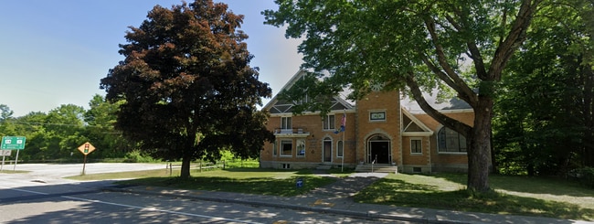
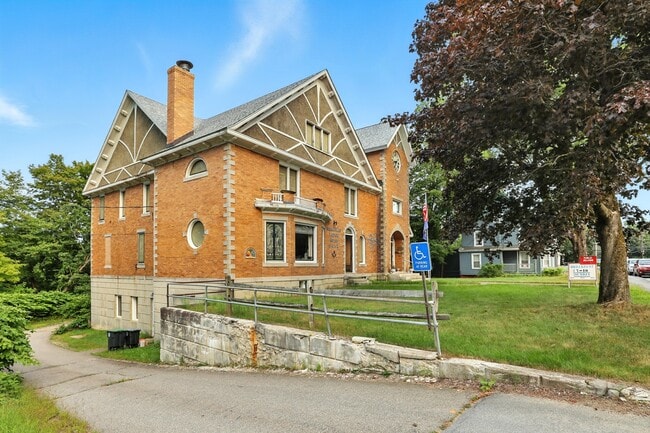
This Property Is For Sale
NEARBY LISTINGS FOR SALE OR LEASE
-
-
View all Franklin listings for sale on LoopNet.com
Property Detail
58 S Main St
Commercialbuilding
Merrimack
X
New Hampshire
33013C0158E
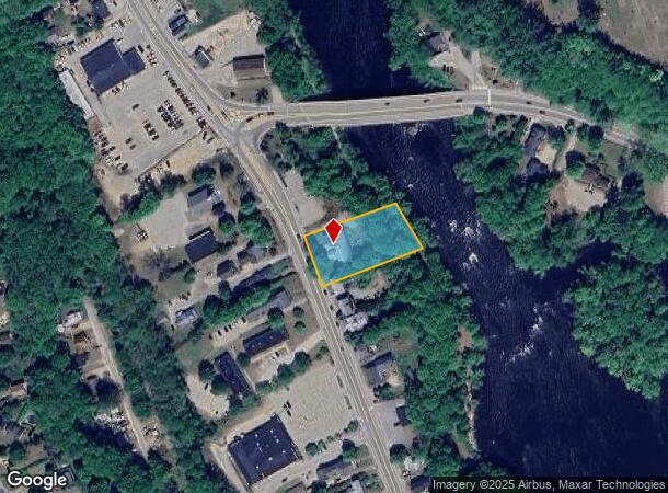
0.82 AC
2024
Concord/New Hampshire North Area
2024
Other Market Areas
043001
Concord, NH
8,120 SF
FRKN-000098-000074
DEMOGRAPHICS near 58 S Main St
1 Mile
3 Mile
5 Mile
2024 Total Population
5,043
10,981
17,784
2029 Population
5,540
11,988
19,244
Pop Growth 2024-2029
+ 9.86%
+ 9.17%
+ 8.21%
Average Age
41
43
43
2024 Total Households
2,086
4,507
7,228
HH Growth 2024-2029
+ 10.16%
+ 9.47%
+ 8.47%
Median Household Inc
$67,356
$76,019
$79,561
Avg Household Size
2.30
2.30
2.40
2024 Avg HH Vehicles
2.00
2.00
2.00
Median Home Value
$245,731
$269,096
$280,821
Median Year Built
1958
1964
1969
Nearby Places
Map Layers
Map Styles
 Street
 Aerial
- Restaurants
- Banks
- Shops
- Fitness
- Groceries
Nearby Properties
Address
Land Use
TOTAL SIZE
Lot Size
Zoning
Address
Land Use
TOTAL SIZE
Lot Size
Zoning
149,800 SF
28 AC
MEDIUM
Address
Land Use
TOTAL SIZE
Lot Size
Zoning
118,611 SF
12.40 AC
VILLAG
Address
Land Use
TOTAL SIZE
Lot Size
Zoning
19,172 SF
83 AC
C
Address
Land Use
TOTAL SIZE
Lot Size
Zoning
64,666 SF
8.65 AC
RSW&S
Address
Land Use
TOTAL SIZE
Lot Size
Zoning
Address
Land Use
TOTAL SIZE
Lot Size
Zoning
80,933 SF
3.79 AC
VILLAG
Address
Land Use
TOTAL SIZE
Lot Size
Zoning
16,833 SF
2.39 AC
B1W&S
Address
Land Use
TOTAL SIZE
Lot Size
Zoning
93,102 SF
8.21 AC
GENERA
Address
Land Use
TOTAL SIZE
Lot Size
Zoning
60.27 AC
R2MFSM
Address
Land Use
TOTAL SIZE
Lot Size
Zoning
83,283 SF
16.81 AC
RSW&S
Address
Land Use
TOTAL SIZE
Lot Size
Zoning
94,330 SF
14.70 AC
B1W&S
Address
Land Use
TOTAL SIZE
Lot Size
Zoning
215,790 SF
18 AC
I1
Address
Land Use
TOTAL SIZE
Lot Size
Zoning
54,592 SF
B1W&S
Address
Land Use
TOTAL SIZE
Lot Size
Zoning
2,032 SF
59.56 AC
MEDIUM
Address
Land Use
TOTAL SIZE
Lot Size
Zoning
6.75 AC
GENERA
Address
Land Use
TOTAL SIZE
Lot Size
Zoning
2,324 SF
388 AC
C
Address
Land Use
TOTAL SIZE
Lot Size
Zoning
44,129 SF
13.23 AC
RSW&S
Address
Land Use
TOTAL SIZE
Lot Size
Zoning
0.32 AC
C/I-1
Address
Land Use
TOTAL SIZE
Lot Size
Zoning
4,832 SF
1.37 AC
R3W&S
Address
Land Use
TOTAL SIZE
Lot Size
Zoning
65,308 SF
2.27 AC
B2
Address
Land Use
TOTAL SIZE
Lot Size
Zoning
44,955 SF
5.22 AC
B1W&S
Address
Land Use
TOTAL SIZE
Lot Size
Zoning
31,620 SF
8.12 AC
RSW&S
Address
Land Use
TOTAL SIZE
Lot Size
Zoning
143,583 SF
25.99 AC
I1W&S
Address
Land Use
TOTAL SIZE
Lot Size
Zoning
8,234 SF
5.70 AC
R2W&S
Address
Land Use
TOTAL SIZE
Lot Size
Zoning
40,321 SF
11.20 AC
R2W&S
Address
Land Use
TOTAL SIZE
Lot Size
Zoning
25,274 SF
1.40 AC
B2
Address
Land Use
TOTAL SIZE
Lot Size
Zoning
44,678 SF
1.40 AC
B2
Address
Land Use
TOTAL SIZE
Lot Size
Zoning
9,321 SF
3.50 AC
R2W&S
Address
Land Use
TOTAL SIZE
Lot Size
Zoning
16,647 SF
1.20 AC
B2
Address
Land Use
TOTAL SIZE
Lot Size
Zoning
8,247 SF
3.50 AC
RS
The World's #1 Commercial Real Estate Marketplace
Connect with us
© 2025 CoStar Group
The information above has been obtained from sources believed reliable. While we do not doubt its accuracy we have not verified it and make no guarantee, warranty or representation about it. It is your responsibility to independently confirm its accuracy and completeness. Any projections, opinions, assumptions, or estimates used are for example only and do not represent the current or future performance of the property. The value of this transaction to you depends on tax and other factors which should be evaluated by your tax, financial, and legal advisors. You and your advisors should conduct a careful, independent investigation of the property to determine to your satisfaction the suitability of the property for your needs.