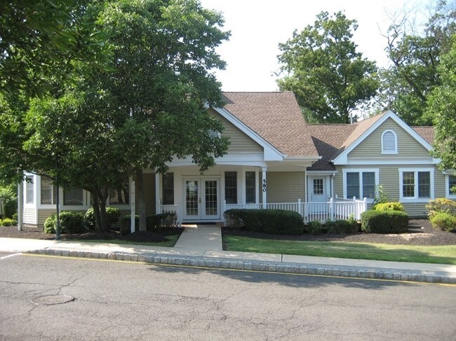
Property Record
580 Allen Rd, Basking Ridge, NJ 07920


NEARBY LISTINGS FOR SALE OR LEASE
Property Detail
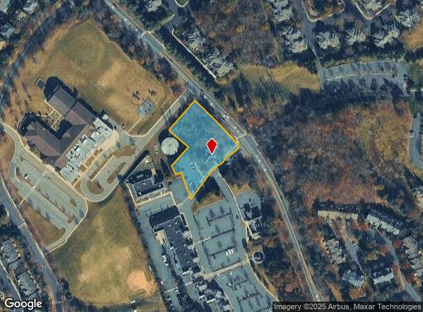
580 Allen Rd
Newark, NJ-PA
Hills Village
02-10001-0000-00002
INCL BLK 173-09 P/O LOT 7
Officebuilding
Somerset
X
New Jersey
34035C0063E
2
2024
1.43 AC
2025
Route 78 East
052605
Northern New Jersey
2,554 SF
DEMOGRAPHICS near 580 Allen Rd
1 Mile
3 Mile
5 Mile
2024 Total Population
9,842
26,136
63,584
2029 Population
9,834
26,013
63,438
Pop Growth 2024-2029
(0.08%)
(0.47%)
(0.23%)
Average Age
43
44
43
2024 Total Households
4,046
10,547
23,717
HH Growth 2024-2029
(0.07%)
(0.47%)
(0.25%)
Median Household Inc
$167,362
$151,422
$160,239
Avg Household Size
2.40
2.40
2.60
2024 Avg HH Vehicles
2.00
2.00
2.00
Median Home Value
$583,625
$591,350
$653,658
Median Year Built
1991
1986
1983
Nearby Places
Map Layers
Map Styles
 Street
 Aerial
- Restaurants
- Banks
- Shops
- Fitness
- Groceries
PUBLIC TRANSPORTATION
COMMUTER RAIL
Far Hills (Morris & Essex Gladstone Branch - NJ Transit Commuter Rail (NJ Transit))
DRIVE
WALK
Distance
Far Hills (Morris & Essex Gladstone Branch - NJ Transit Commuter Rail (NJ Transit))
7 min
2.9 mi
Peapack (Morris & Essex Gladstone Branch - NJ Transit Commuter Rail (NJ Transit))
DRIVE
WALK
Distance
Peapack (Morris & Essex Gladstone Branch - NJ Transit Commuter Rail (NJ Transit))
11 min
6.2 mi
AIRPORT
Newark Liberty International
DRIVE
WALK
Distance
Newark Liberty International
38 min
29.2 mi
Trenton Mercer
DRIVE
WALK
Distance
Trenton Mercer
63 min
39.4 mi
Freight Ports
New York Container Terminal
DRIVE
WALK
Distance
New York Container Terminal
48 min
32.1 mi
SALE & LEASE HISTORY
LISTING DATE
SALE/LEASE

Nov 01, 2016
For Sale
Nearby Properties
Address
Land Use
TOTAL SIZE
Lot Size
Zoning
Address
Land Use
TOTAL SIZE
Lot Size
Zoning
Address
Land Use
TOTAL SIZE
Lot Size
Zoning
196.68 AC
OR
Address
Land Use
TOTAL SIZE
Lot Size
Zoning
2.82 AC
SED
Address
Land Use
TOTAL SIZE
Lot Size
Zoning
56.79 AC
R2
Address
Land Use
TOTAL SIZE
Lot Size
Zoning
85,000 SF
25.62 AC
E3
Address
Land Use
TOTAL SIZE
Lot Size
Zoning
46.96 AC
OR
Address
Land Use
TOTAL SIZE
Lot Size
Zoning
23.08 AC
OR
Address
Land Use
TOTAL SIZE
Lot Size
Zoning
12.74 AC
PUD
Address
Land Use
TOTAL SIZE
Lot Size
Zoning
13.94 AC
PUD
Address
Land Use
TOTAL SIZE
Lot Size
Zoning
15 AC
R2
Address
Land Use
TOTAL SIZE
Lot Size
Zoning
146.60 AC
SED
Address
Land Use
TOTAL SIZE
Lot Size
Zoning
1.21 AC
SED
Address
Land Use
TOTAL SIZE
Lot Size
Zoning
2,848 SF
22.47 AC
ORVM
Address
Land Use
TOTAL SIZE
Lot Size
Zoning
10.06 AC
R40
Address
Land Use
TOTAL SIZE
Lot Size
Zoning
17.63 AC
OR
Address
Land Use
TOTAL SIZE
Lot Size
Zoning
Address
Land Use
TOTAL SIZE
Lot Size
Zoning
25.64 AC
E2
Address
Land Use
TOTAL SIZE
Lot Size
Zoning
30.52 AC
R50
Address
Land Use
TOTAL SIZE
Lot Size
Zoning
2,726 SF
10.01 AC
VN
Address
Land Use
TOTAL SIZE
Lot Size
Zoning
12.94 AC
SED
Address
Land Use
TOTAL SIZE
Lot Size
Zoning
49,786 SF
13.84 AC
VN2
Address
Land Use
TOTAL SIZE
Lot Size
Zoning
126,360 SF
36.03 AC
E3
Address
Land Use
TOTAL SIZE
Lot Size
Zoning
31.58 AC
OR
Address
Land Use
TOTAL SIZE
Lot Size
Zoning
13.07 AC
OR
Address
Land Use
TOTAL SIZE
Lot Size
Zoning
1,428 SF
19.52 AC
E2
Address
Land Use
TOTAL SIZE
Lot Size
Zoning
62,250 SF
14.43 AC
E2
Address
Land Use
TOTAL SIZE
Lot Size
Zoning
15.22 AC
OR
Address
Land Use
TOTAL SIZE
Lot Size
Zoning
34.61 AC
E3
Address
Land Use
TOTAL SIZE
Lot Size
Zoning
67,407 SF
41.85 AC
R1
Address
Land Use
TOTAL SIZE
Lot Size
Zoning
12 AC
P3
The World's #1 Commercial Real Estate Marketplace
Connect with us
© 2025 CoStar Group
The information above has been obtained from sources believed reliable. While we do not doubt its accuracy we have not verified it and make no guarantee, warranty or representation about it. It is your responsibility to independently confirm its accuracy and completeness. Any projections, opinions, assumptions, or estimates used are for example only and do not represent the current or future performance of the property. The value of this transaction to you depends on tax and other factors which should be evaluated by your tax, financial, and legal advisors. You and your advisors should conduct a careful, independent investigation of the property to determine to your satisfaction the suitability of the property for your needs.