Property Record
580 Mesa Blvd, Mesquite, NV 89027
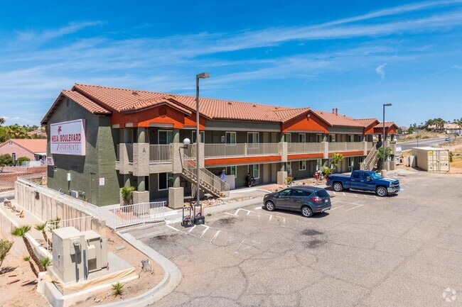
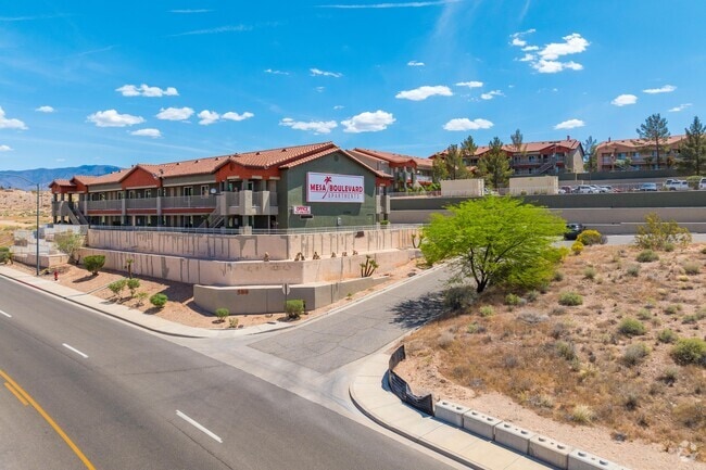

Property Detail
580 Mesa Blvd
001-10-201-009
PARCEL MAP FILE 72 PAGE 10 LOT 1
Motel
Clark
CR2
Nevada
B and X Area of moderate flood hazard, usually the area between the limits of the 100-year and 500-year floods.
1
2026
3.74 AC
2026
North Outlying Clark County
005903
Las Vegas
52,240 SF
Las Vegas-Henderson-North Las Vegas, NV
NEARBY LISTINGS FOR SALE OR LEASE
-
-
View all Mesquite listings for sale on LoopNet.com
DEMOGRAPHICS near 580 Mesa Blvd
1 mile
3 mile
5 mile
2025 Total Population
5,652
20,840
27,018
2030 Population
6,132
22,499
29,088
Pop Growth 2025-2030
+ 8.49%
+ 7.96%
+ 7.66%
Average Age
54
52
54
2025 Total Households
2,686
9,364
12,382
HH Growth 2025-2030
+ 8.49%
+ 8.08%
+ 7.88%
Median Household Inc
$68,518
$74,974
$75,935
Avg Household Size
2.00
2.20
2.10
2025 Avg HH Vehicles
2.00
2.00
2.00
Median Home Value
$425,190
$416,221
$427,708
Median Year Built
2000
2003
2004
Nearby Places
Map Layers
Map Styles
 Street
 Aerial
Layers
 Traffic
 Biking
Places
Listings with unknown addresses are not visible on the map
- Restaurants
- Banks
- Shops
- Fitness
- Groceries
SALE & LEASE HISTORY
LISTING DATE
SALE/LEASE

Oct 15, 2019
For Sale
Dec 05, 2022
For Sale
Apr 01, 2022
For Sale
Nearby Properties
Address
Land Use
TOTAL SIZE
Lot Size
Zoning
Address
Land Use
TOTAL SIZE
Lot Size
Zoning
148,373 SF
19.35 AC
HT
Address
Land Use
TOTAL SIZE
Lot Size
Zoning
197,938 SF
35.63 AC
HT
Address
Land Use
TOTAL SIZE
Lot Size
Zoning
123,397 SF
26.60 AC
HT
Address
Land Use
TOTAL SIZE
Lot Size
Zoning
496,775 SF
5.02 AC
HT
Address
Land Use
TOTAL SIZE
Lot Size
Zoning
33.73 AC
PF
Address
Land Use
TOTAL SIZE
Lot Size
Zoning
3,450 SF
4.93 AC
PB
Address
Land Use
TOTAL SIZE
Lot Size
Zoning
37.78 AC
PROS
Address
Land Use
TOTAL SIZE
Lot Size
Zoning
12.49 AC
PF
Address
Land Use
TOTAL SIZE
Lot Size
Zoning
154,961 SF
17.17 AC
PUD
Address
Land Use
TOTAL SIZE
Lot Size
Zoning
67,184 SF
14.69 AC
HT
Address
Land Use
TOTAL SIZE
Lot Size
Zoning
6,831 SF
6.01 AC
CR2
Address
Land Use
TOTAL SIZE
Lot Size
Zoning
10.09 AC
PF
Address
Land Use
TOTAL SIZE
Lot Size
Zoning
73,517 SF
164.64 AC
PF
Address
Land Use
TOTAL SIZE
Lot Size
Zoning
17,110 SF
2.11 AC
Address
Land Use
TOTAL SIZE
Lot Size
Zoning
111,642 SF
8.35 AC
IR1
Address
Land Use
TOTAL SIZE
Lot Size
Zoning
47,328 SF
4.65 AC
CR2
Address
Land Use
TOTAL SIZE
Lot Size
Zoning
1,056 SF
5.96 AC
MF4
Address
Land Use
TOTAL SIZE
Lot Size
Zoning
60,114 SF
5.54 AC
HT
Address
Land Use
TOTAL SIZE
Lot Size
Zoning
13,286 SF
1.63 AC
Address
Land Use
TOTAL SIZE
Lot Size
Zoning
4.11 AC
CR3
Address
Land Use
TOTAL SIZE
Lot Size
Zoning
4,577 SF
185.32 AC
PUD
Address
Land Use
TOTAL SIZE
Lot Size
Zoning
36,233 SF
3.31 AC
PUD
Address
Land Use
TOTAL SIZE
Lot Size
Zoning
6.85 AC
PF
Address
Land Use
TOTAL SIZE
Lot Size
Zoning
20,299 SF
0.99 AC
CR2
Address
Land Use
TOTAL SIZE
Lot Size
Zoning
34,737 SF
2.54 AC
Address
Land Use
TOTAL SIZE
Lot Size
Zoning
34,032 SF
3.15 AC
PUD
The World's #1 Commercial Real Estate Marketplace
Connect with us
© 2026 CoStar Group
The information above has been obtained from sources believed reliable. While we do not doubt its accuracy we have not verified it and make no guarantee, warranty or representation about it. It is your responsibility to independently confirm its accuracy and completeness. Any projections, opinions, assumptions, or estimates used are for example only and do not represent the current or future performance of the property. The value of this transaction to you depends on tax and other factors which should be evaluated by your tax, financial, and legal advisors. You and your advisors should conduct a careful, independent investigation of the property to determine to your satisfaction the suitability of the property for your needs.