Property Record
5800 Engle Rd, Carmichael, CA 95608


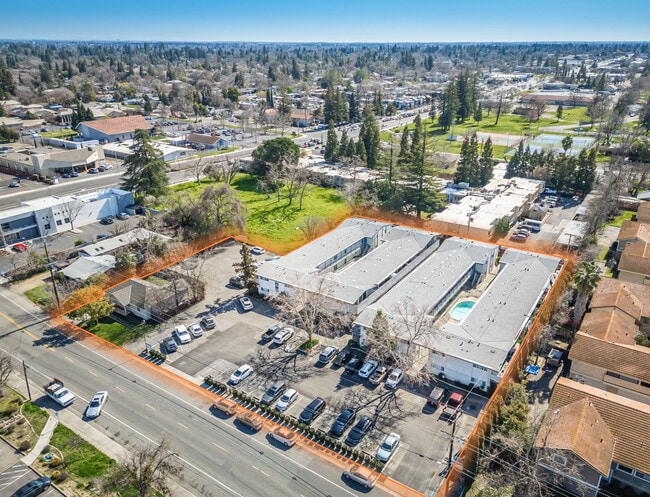
Property Detail
5800 Engle Rd
258-0180-043
POR OF SE 1/4 SEC 54 RANCHO DEL PASO DES AS FOLSBEG AT PT LOC S 89%02'30W 257.27 FT FR NE COR OF S E 1/4 SEC 54 TH FR SD P O B S 01%46'E 283.40FT TH S 89%02'30W 194 FT TH N 01%46' W 283.40 FT TH N 89%02'30 E 194 FT TO THE P O B - FMLY 258-1
Apartment
Sacramento
SPA
California
B and X Area of moderate flood hazard, usually the area between the limits of the 100-year and 500-year floods.
2.04 AC
2024
Outer Carmichael/Citrus Heights
2025
Sacramento
007602
Sacramento-Roseville-Folsom, CA
35,264 SF
NEARBY LISTINGS FOR SALE OR LEASE
DEMOGRAPHICS near 5800 Engle Rd
1 mile
3 mile
5 mile
2025 Total Population
16,015
141,462
377,766
2030 Population
16,150
142,628
381,375
Pop Growth 2025-2030
+ 0.84%
+ 0.82%
+ 0.96%
Average Age
43
41
40
2025 Total Households
6,454
55,340
144,992
HH Growth 2025-2030
+ 0.85%
+ 0.83%
+ 0.97%
Median Household Inc
$86,486
$84,854
$81,767
Avg Household Size
2.40
2.50
2.50
2025 Avg HH Vehicles
2.00
2.00
2.00
Median Home Value
$615,980
$531,375
$484,484
Median Year Built
1973
1969
1972
Nearby Places
Map Layers
Map Styles
 Street
 Aerial
Transit
 Traffic
 Biking
Places
Listings with unknown addresses are not visible on the map
- Restaurants
- Banks
- Shops
- Fitness
- Groceries
PUBLIC TRANSPORTATION
AIRPORT
Sacramento International
Drive
Walk
Distance
Sacramento International
31 min
19.6 mi
Freight Ports
Port of Stockton
Drive
Walk
Distance
Port of Stockton
72 min
59.0 mi
SALE & LEASE HISTORY
LISTING DATE
SALE/LEASE

Apr 04, 2025
For Sale
Nearby Properties
Address
Land Use
TOTAL SIZE
Lot Size
Zoning
Address
Land Use
TOTAL SIZE
Lot Size
Zoning
512,630 SF
37.68 AC
SPA (NPA)
Address
Land Use
TOTAL SIZE
Lot Size
Zoning
212,037 SF
17.20 AC
BP
Address
Land Use
TOTAL SIZE
Lot Size
Zoning
145,334 SF
8.84 AC
RD-20
Address
Land Use
TOTAL SIZE
Lot Size
Zoning
278,877 SF
13.17 AC
RD-30
Address
Land Use
TOTAL SIZE
Lot Size
Zoning
75,700 SF
4.02 AC
RD-40
Address
Land Use
TOTAL SIZE
Lot Size
Zoning
21,890 SF
0.50 AC
SC
Address
Land Use
TOTAL SIZE
Lot Size
Zoning
99,408 SF
3.53 AC
BP
Address
Land Use
TOTAL SIZE
Lot Size
Zoning
136,483 SF
3.77 AC
BP
Address
Land Use
TOTAL SIZE
Lot Size
Zoning
140,102 SF
3.30 AC
RD-20
Address
Land Use
TOTAL SIZE
Lot Size
Zoning
89,098 SF
4.93 AC
RD-40
Address
Land Use
TOTAL SIZE
Lot Size
Zoning
148,576 SF
4.84 AC
RD-30
Address
Land Use
TOTAL SIZE
Lot Size
Zoning
43,183 SF
12.35 AC
H F
Address
Land Use
TOTAL SIZE
Lot Size
Zoning
72,119 SF
2.38 AC
BP (NPA)
Address
Land Use
TOTAL SIZE
Lot Size
Zoning
1,484 SF
4.94 AC
RD-20
Address
Land Use
TOTAL SIZE
Lot Size
Zoning
90,972 SF
2.36 AC
RD-40
Address
Land Use
TOTAL SIZE
Lot Size
Zoning
135,053 SF
6.66 AC
LC SC RD-4
Address
Land Use
TOTAL SIZE
Lot Size
Zoning
110,533 SF
4.17 AC
RD-5 RD-40
Address
Land Use
TOTAL SIZE
Lot Size
Zoning
100,529 SF
13.65 AC
RD-10 BP
Address
Land Use
TOTAL SIZE
Lot Size
Zoning
166,300 SF
8.04 AC
RD-40 RD-2
Address
Land Use
TOTAL SIZE
Lot Size
Zoning
103,414 SF
5.01 AC
RD-30
Address
Land Use
TOTAL SIZE
Lot Size
Zoning
106,437 SF
4.73 AC
RD-30
Address
Land Use
TOTAL SIZE
Lot Size
Zoning
100,462 SF
5.02 AC
RD-30
Address
Land Use
TOTAL SIZE
Lot Size
Zoning
130,708 SF
8.85 AC
RD-30
Address
Land Use
TOTAL SIZE
Lot Size
Zoning
120,568 SF
5.64 AC
RD-30
Address
Land Use
TOTAL SIZE
Lot Size
Zoning
60,582 SF
3.55 AC
RD-20
Address
Land Use
TOTAL SIZE
Lot Size
Zoning
138,601 SF
13.78 AC
SC
Address
Land Use
TOTAL SIZE
Lot Size
Zoning
44,208 SF
3.17 AC
RD-20
Address
Land Use
TOTAL SIZE
Lot Size
Zoning
78,238 SF
3.37 AC
RD-30
Address
Land Use
TOTAL SIZE
Lot Size
Zoning
42,662 SF
3.08 AC
TC
Address
Land Use
TOTAL SIZE
Lot Size
Zoning
56,243 SF
2.23 AC
RD-5
The World's #1 Commercial Real Estate Marketplace
Connect with us
© 2026 CoStar Group
The information above has been obtained from sources believed reliable. While we do not doubt its accuracy we have not verified it and make no guarantee, warranty or representation about it. It is your responsibility to independently confirm its accuracy and completeness. Any projections, opinions, assumptions, or estimates used are for example only and do not represent the current or future performance of the property. The value of this transaction to you depends on tax and other factors which should be evaluated by your tax, financial, and legal advisors. You and your advisors should conduct a careful, independent investigation of the property to determine to your satisfaction the suitability of the property for your needs.