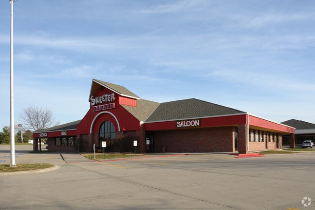
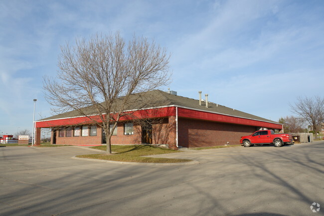
Property Record
5800 N 58Th St, Lincoln, NE 68507
NEARBY LISTINGS FOR SALE OR LEASE
Property Detail
5800 N 58Th St
Lincoln, NE
Froehlich Industrial Park
17-04-110-006-000
COUNTRY PLACE 28TH ADDITION, LOT 1
Commercialnec
Lancaster
X
Nebraska
31109C0310F
1
2024
1.52 AC
2025
Far South
003714
Lincoln
28,280 SF
DEMOGRAPHICS near 5800 N 58Th St
1 Mile
3 Mile
5 Mile
2024 Total Population
9,400
88,415
166,819
2029 Population
9,656
91,469
172,948
Pop Growth 2024-2029
+ 2.72%
+ 3.45%
+ 3.67%
Average Age
40
41
40
2024 Total Households
3,726
36,453
71,136
HH Growth 2024-2029
+ 2.79%
+ 3.48%
+ 3.75%
Median Household Inc
$85,606
$86,376
$69,999
Avg Household Size
2.50
2.40
2.30
2024 Avg HH Vehicles
2.00
2.00
2.00
Median Home Value
$258,601
$279,156
$260,244
Median Year Built
1982
1989
1977
Nearby Places
Map Layers
Map Styles
 Street
 Aerial
- Restaurants
- Banks
- Shops
- Fitness
- Groceries
PUBLIC TRANSPORTATION
COMMUTER RAIL
Lincoln Amtrak Station (California Zephyr - Amtrak)
DRIVE
WALK
Distance
Lincoln Amtrak Station (California Zephyr - Amtrak)
12 min
6.3 mi
AIRPORT
Lincoln
DRIVE
WALK
Distance
Lincoln
15 min
10.0 mi
Freight Ports
Tulsa Port Of Catoosa
DRIVE
WALK
Distance
Tulsa Port Of Catoosa
476 min
395.9 mi
Nearby Properties
Address
Land Use
TOTAL SIZE
Lot Size
Zoning
Address
Land Use
TOTAL SIZE
Lot Size
Zoning
382,244 SF
44.25 AC
R6
Address
Land Use
TOTAL SIZE
Lot Size
Zoning
293,488 SF
570.28 AC
Address
Land Use
TOTAL SIZE
Lot Size
Zoning
48,088 SF
28.06 AC
R5
Address
Land Use
TOTAL SIZE
Lot Size
Zoning
32,110 SF
14.60 AC
R5
Address
Land Use
TOTAL SIZE
Lot Size
Zoning
27,171 SF
14.68 AC
NULL
Address
Land Use
TOTAL SIZE
Lot Size
Zoning
430,949 SF
41.47 AC
P
Address
Land Use
TOTAL SIZE
Lot Size
Zoning
65,064 SF
1.39 AC
R6
Address
Land Use
TOTAL SIZE
Lot Size
Zoning
32,110 SF
9.64 AC
B2
Address
Land Use
TOTAL SIZE
Lot Size
Zoning
41,456 SF
4.95 AC
B2
Address
Land Use
TOTAL SIZE
Lot Size
Zoning
8,824 SF
12.33 AC
R5
Address
Land Use
TOTAL SIZE
Lot Size
Zoning
65,967 SF
11.65 AC
NULL
Address
Land Use
TOTAL SIZE
Lot Size
Zoning
10,688 SF
237.77 AC
P
Address
Land Use
TOTAL SIZE
Lot Size
Zoning
63,914 SF
12.22 AC
R5
Address
Land Use
TOTAL SIZE
Lot Size
Zoning
46,906 SF
2.88 AC
Address
Land Use
TOTAL SIZE
Lot Size
Zoning
38,769 SF
11.81 AC
NULL
Address
Land Use
TOTAL SIZE
Lot Size
Zoning
92,054 SF
6.22 AC
R5
Address
Land Use
TOTAL SIZE
Lot Size
Zoning
69,760 SF
1.81 AC
Address
Land Use
TOTAL SIZE
Lot Size
Zoning
360,422 SF
23.53 AC
B5
Address
Land Use
TOTAL SIZE
Lot Size
Zoning
69,652 SF
3.10 AC
B3
Address
Land Use
TOTAL SIZE
Lot Size
Zoning
36,041 SF
5.43 AC
R5
Address
Land Use
TOTAL SIZE
Lot Size
Zoning
1,500 SF
230.35 AC
P
Address
Land Use
TOTAL SIZE
Lot Size
Zoning
17,312 SF
177.49 AC
AG
Address
Land Use
TOTAL SIZE
Lot Size
Zoning
154.12 AC
P
Address
Land Use
TOTAL SIZE
Lot Size
Zoning
759,282 SF
40.67 AC
I1
Address
Land Use
TOTAL SIZE
Lot Size
Zoning
80,763 SF
15.61 AC
R3
Address
Land Use
TOTAL SIZE
Lot Size
Zoning
294,243 SF
93.02 AC
I1
Address
Land Use
TOTAL SIZE
Lot Size
Zoning
12,510 SF
5.47 AC
R4
Address
Land Use
TOTAL SIZE
Lot Size
Zoning
211,006 SF
17.33 AC
B5
Address
Land Use
TOTAL SIZE
Lot Size
Zoning
106,194 SF
44.89 AC
I3
Address
Land Use
TOTAL SIZE
Lot Size
Zoning
73,167 SF
3.63 AC
B2
The World's #1 Commercial Real Estate Marketplace
Connect with us
© 2025 CoStar Group
The information above has been obtained from sources believed reliable. While we do not doubt its accuracy we have not verified it and make no guarantee, warranty or representation about it. It is your responsibility to independently confirm its accuracy and completeness. Any projections, opinions, assumptions, or estimates used are for example only and do not represent the current or future performance of the property. The value of this transaction to you depends on tax and other factors which should be evaluated by your tax, financial, and legal advisors. You and your advisors should conduct a careful, independent investigation of the property to determine to your satisfaction the suitability of the property for your needs.