Property Record
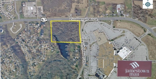
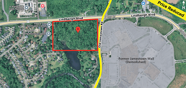
5800 N Highway 67 St, Florissant, MO 63034

This Property Is For Sale
NEARBY LISTINGS FOR SALE OR LEASE
Property Detail
5800 N Highway 67 St
St. Louis, MO-IL
Survey 0000 Sec 08 Twn 47 Range 7
06F-41-0058
SURVEY 0000 SEC 08 TWN 47 RANGE 7 & SEC 17 LOC 440 FEET W OF OLD JAMESTOWN RD
Vacantlandnec
St. Louis
X
Missouri
29183C0325G
3.12 AC
2024
North County
2025
St. Louis
210912
DEMOGRAPHICS near 5800 N Highway 67 St
1 Mile
3 Mile
5 Mile
2024 Total Population
2,711
42,545
126,648
2029 Population
2,641
41,773
124,860
Pop Growth 2024-2029
(2.58%)
(1.81%)
(1.41%)
Average Age
43
42
40
2024 Total Households
1,046
16,892
49,383
HH Growth 2024-2029
(2.68%)
(1.77%)
(1.43%)
Median Household Inc
$89,418
$67,755
$58,080
Avg Household Size
2.60
2.40
2.50
2024 Avg HH Vehicles
2.00
2.00
2.00
Median Home Value
$177,607
$159,234
$145,135
Median Year Built
1984
1972
1967
Nearby Places
- Restaurants
- Banks
- Shops
- Fitness
- Groceries
PUBLIC TRANSPORTATION
AIRPORT
St Louis Lambert International
DRIVE
WALK
Distance
St Louis Lambert International
18 min
9.1 mi
Scott AFB/Midamerica St Louis
DRIVE
WALK
Distance
Scott AFB/Midamerica St Louis
60 min
39.3 mi
Freight Ports
Port Milwaukee
DRIVE
WALK
Distance
Port Milwaukee
423 min
373.0 mi
Nearby Properties
Address
Land Use
TOTAL SIZE
Lot Size
Zoning
Address
Land Use
TOTAL SIZE
Lot Size
Zoning
15.37 AC
R
Address
Land Use
TOTAL SIZE
Lot Size
Zoning
271,184 SF
13.67 AC
B3
Address
Land Use
TOTAL SIZE
Lot Size
Zoning
93,136 SF
108.76 AC
Address
Land Use
TOTAL SIZE
Lot Size
Zoning
354,790 SF
22.46 AC
B6
Address
Land Use
TOTAL SIZE
Lot Size
Zoning
1,294,178 SF
142.42 AC
C-8
Address
Land Use
TOTAL SIZE
Lot Size
Zoning
21.29 AC
24R4
Address
Land Use
TOTAL SIZE
Lot Size
Zoning
2,429 SF
79.10 AC
NU
Address
Land Use
TOTAL SIZE
Lot Size
Zoning
293,117 SF
26 AC
R3
Address
Land Use
TOTAL SIZE
Lot Size
Zoning
169,426 SF
26.38 AC
R1
Address
Land Use
TOTAL SIZE
Lot Size
Zoning
50.71 AC
R3D
Address
Land Use
TOTAL SIZE
Lot Size
Zoning
47,184 SF
119.33 AC
PS
Address
Land Use
TOTAL SIZE
Lot Size
Zoning
20.62 AC
R3
Address
Land Use
TOTAL SIZE
Lot Size
Zoning
193,344 SF
14.37 AC
24MFD
Address
Land Use
TOTAL SIZE
Lot Size
Zoning
18.86 AC
R3
Address
Land Use
TOTAL SIZE
Lot Size
Zoning
231.84 AC
NU
Address
Land Use
TOTAL SIZE
Lot Size
Zoning
218,822 SF
15.94 AC
R6
Address
Land Use
TOTAL SIZE
Lot Size
Zoning
1,797 SF
23.66 AC
NU
Address
Land Use
TOTAL SIZE
Lot Size
Zoning
179,262 SF
9.58 AC
R2
Address
Land Use
TOTAL SIZE
Lot Size
Zoning
Address
Land Use
TOTAL SIZE
Lot Size
Zoning
136,874 SF
13.18 AC
R1
Address
Land Use
TOTAL SIZE
Lot Size
Zoning
10 AC
R3
Address
Land Use
TOTAL SIZE
Lot Size
Zoning
7.99 AC
103R-1
Address
Land Use
TOTAL SIZE
Lot Size
Zoning
120.20 AC
PS
Address
Land Use
TOTAL SIZE
Lot Size
Zoning
7.19 AC
NU
Address
Land Use
TOTAL SIZE
Lot Size
Zoning
217,644 SF
12.07 AC
R6
Address
Land Use
TOTAL SIZE
Lot Size
Zoning
90,985 SF
7.77 AC
C-8
Address
Land Use
TOTAL SIZE
Lot Size
Zoning
96,094 SF
8.84 AC
103R-2
Address
Land Use
TOTAL SIZE
Lot Size
Zoning
Address
Land Use
TOTAL SIZE
Lot Size
Zoning
73,472 SF
66.01 AC
NU
Address
Land Use
TOTAL SIZE
Lot Size
Zoning
68,225 SF
9.01 AC
C2
The World's #1 Commercial Real Estate Marketplace
Connect with us
© 2025 CoStar Group
The information above has been obtained from sources believed reliable. While we do not doubt its accuracy we have not verified it and make no guarantee, warranty or representation about it. It is your responsibility to independently confirm its accuracy and completeness. Any projections, opinions, assumptions, or estimates used are for example only and do not represent the current or future performance of the property. The value of this transaction to you depends on tax and other factors which should be evaluated by your tax, financial, and legal advisors. You and your advisors should conduct a careful, independent investigation of the property to determine to your satisfaction the suitability of the property for your needs.