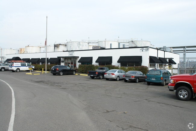
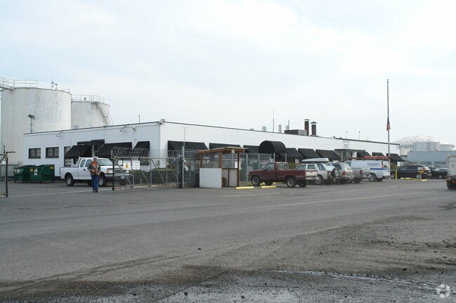
Property Record
5800 Nw Wi/ Northwest St Helens Rd, Portland, OR 97210
NEARBY LISTINGS FOR SALE OR LEASE
Property Detail
5800 Nw Wi/ Northwest St Helens Rd
R646358
Bridgeport
Heavyindustrial
SECTION 13 1N 1W, TL 200 1.29 ACRES
ARE
Multnomah
41067C0400E
Oregon
2025
Guilds Lake
2025
Portland
004700
Portland-Vancouver-Hillsboro, OR-WA
DEMOGRAPHICS near 5800 Nw Wi/ Northwest St Helens Rd
1 Mile
3 Mile
5 Mile
2024 Total Population
228
62,808
261,873
2029 Population
222
61,571
260,910
Pop Growth 2024-2029
(2.63%)
(1.97%)
(0.37%)
Average Age
38
38
40
2024 Total Households
80
24,298
119,126
HH Growth 2024-2029
(3.75%)
(2.26%)
(0.46%)
Median Household Inc
$106,250
$104,782
$91,471
Avg Household Size
2.50
2.40
2.10
2024 Avg HH Vehicles
2.00
2.00
1.00
Median Home Value
$657,894
$580,348
$658,596
Median Year Built
1955
1964
1980
Nearby Places
Map Layers
Map Styles
 Street
 Aerial
- Restaurants
- Banks
- Shops
- Fitness
- Groceries
PUBLIC TRANSPORTATION
COMMUTER RAIL
Portland (Amtrak Cascades - Amtrak, Coast Starlight - Amtrak, Empire Builder - Amtrak)
DRIVE
WALK
Distance
Portland (Amtrak Cascades - Amtrak, Coast Starlight - Amtrak, Empire Builder - Amtrak)
11 min
4.8 mi
AIRPORT
Portland International
DRIVE
WALK
Distance
Portland International
28 min
14.7 mi
Freight Ports
Port of Portland
DRIVE
WALK
Distance
Port of Portland
5 min
2.8 mi
Nearby Properties
Address
Land Use
TOTAL SIZE
Lot Size
Zoning
Address
Land Use
TOTAL SIZE
Lot Size
Zoning
200,109 SF
70.44 AC
IH
Address
Land Use
TOTAL SIZE
Lot Size
Zoning
882,480 SF
80.73 AC
CI1
Address
Land Use
TOTAL SIZE
Lot Size
Zoning
Address
Land Use
TOTAL SIZE
Lot Size
Zoning
262,045 SF
17.10 AC
R5
Address
Land Use
TOTAL SIZE
Lot Size
Zoning
645,294 SF
5.64 AC
CO2D
Address
Land Use
TOTAL SIZE
Lot Size
Zoning
191,506 SF
10.43 AC
IH
Address
Land Use
TOTAL SIZE
Lot Size
Zoning
537,280 SF
NULL
Address
Land Use
TOTAL SIZE
Lot Size
Zoning
318,562 SF
33.59 AC
CI1
Address
Land Use
TOTAL SIZE
Lot Size
Zoning
Address
Land Use
TOTAL SIZE
Lot Size
Zoning
100 SF
82.93 AC
IH
Address
Land Use
TOTAL SIZE
Lot Size
Zoning
73,657 SF
1.90 AC
CI1
Address
Land Use
TOTAL SIZE
Lot Size
Zoning
8.01 AC
EG2
Address
Land Use
TOTAL SIZE
Lot Size
Zoning
963,658 SF
64.43 AC
IH
Address
Land Use
TOTAL SIZE
Lot Size
Zoning
37,770 SF
6.90 AC
EG2
Address
Land Use
TOTAL SIZE
Lot Size
Zoning
610,230 SF
26.65 AC
IH
Address
Land Use
TOTAL SIZE
Lot Size
Zoning
Address
Land Use
TOTAL SIZE
Lot Size
Zoning
Address
Land Use
TOTAL SIZE
Lot Size
Zoning
909,769 SF
29.86 AC
IHI
Address
Land Use
TOTAL SIZE
Lot Size
Zoning
229,981 SF
5.29 AC
EG2_EG2C
Address
Land Use
TOTAL SIZE
Lot Size
Zoning
Address
Land Use
TOTAL SIZE
Lot Size
Zoning
215,104 SF
NULL
Address
Land Use
TOTAL SIZE
Lot Size
Zoning
24.90 AC
IG2
Address
Land Use
TOTAL SIZE
Lot Size
Zoning
212,785 SF
22.27 AC
IG2
Address
Land Use
TOTAL SIZE
Lot Size
Zoning
96,513 SF
1.74 AC
CI1
Address
Land Use
TOTAL SIZE
Lot Size
Zoning
93,519 SF
1.12 AC
CI1
Address
Land Use
TOTAL SIZE
Lot Size
Zoning
301,812 SF
17.46 AC
IG2
Address
Land Use
TOTAL SIZE
Lot Size
Zoning
Address
Land Use
TOTAL SIZE
Lot Size
Zoning
137,784 SF
8.36 AC
RM1
Address
Land Use
TOTAL SIZE
Lot Size
Zoning
175,080 SF
13.28 AC
IG2I
The World's #1 Commercial Real Estate Marketplace
Connect with us
© 2026 CoStar Group
The information above has been obtained from sources believed reliable. While we do not doubt its accuracy we have not verified it and make no guarantee, warranty or representation about it. It is your responsibility to independently confirm its accuracy and completeness. Any projections, opinions, assumptions, or estimates used are for example only and do not represent the current or future performance of the property. The value of this transaction to you depends on tax and other factors which should be evaluated by your tax, financial, and legal advisors. You and your advisors should conduct a careful, independent investigation of the property to determine to your satisfaction the suitability of the property for your needs.