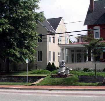
Property Record
5801 Kennett Pike, Wilmington, DE 19807

NEARBY LISTINGS FOR SALE OR LEASE
Property Detail
5801 Kennett Pike
07-007.00-033
Centreville Prof Plz
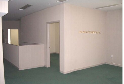
Officebuilding
New Castle
X
Delaware
10003C0055K
c v
2024
0.57 AC
2024
West New Castle County
011800
Philadelphia
11,872 SF
Philadelphia-Camden-Wilmington, PA-NJ-DE-MD
DEMOGRAPHICS near 5801 Kennett Pike
1 Mile
3 Mile
5 Mile
2024 Total Population
1,167
6,963
61,250
2029 Population
1,195
7,249
62,698
Pop Growth 2024-2029
+ 2.40%
+ 4.11%
+ 2.36%
Average Age
48
49
45
2024 Total Households
450
2,679
24,354
HH Growth 2024-2029
+ 2.44%
+ 4.29%
+ 2.46%
Median Household Inc
$165,948
$137,709
$122,186
Avg Household Size
2.50
2.50
2.40
2024 Avg HH Vehicles
2.00
2.00
2.00
Median Home Value
$741,210
$708,604
$484,909
Median Year Built
1965
1980
1973
Nearby Places
Map Layers
Map Styles
 Street
 Aerial
- Restaurants
- Banks
- Shops
- Fitness
- Groceries
PUBLIC TRANSPORTATION
AIRPORT
Philadelphia International
DRIVE
WALK
Distance
Philadelphia International
41 min
26.9 mi
SALE & LEASE HISTORY
LISTING DATE
SALE/LEASE

Jul 18, 2017
For Lease
Nearby Properties
Address
Land Use
TOTAL SIZE
Lot Size
Zoning
Address
Land Use
TOTAL SIZE
Lot Size
Zoning
78,491 SF
38.30 AC
R3
Address
Land Use
TOTAL SIZE
Lot Size
Zoning
27,009 SF
10 AC
SE
Address
Land Use
TOTAL SIZE
Lot Size
Zoning
85,568 SF
6.20 AC
C1
Address
Land Use
TOTAL SIZE
Lot Size
Zoning
18,489 SF
180.78 AC
SE
Address
Land Use
TOTAL SIZE
Lot Size
Zoning
108,829 SF
11.80 AC
SA
Address
Land Use
TOTAL SIZE
Lot Size
Zoning
86,184 SF
12 AC
SA
Address
Land Use
TOTAL SIZE
Lot Size
Zoning
13,323 SF
47.10 AC
R2
Address
Land Use
TOTAL SIZE
Lot Size
Zoning
9,988 SF
223.03 AC
Address
Land Use
TOTAL SIZE
Lot Size
Zoning
197 AC
R1
Address
Land Use
TOTAL SIZE
Lot Size
Zoning
10,419 SF
36.70 AC
R1
Address
Land Use
TOTAL SIZE
Lot Size
Zoning
9,136 SF
NCPUD
Address
Land Use
TOTAL SIZE
Lot Size
Zoning
8,398 SF
2.65 AC
CR
Address
Land Use
TOTAL SIZE
Lot Size
Zoning
162.50 AC
R1
Address
Land Use
TOTAL SIZE
Lot Size
Zoning
3,550 SF
71.08 AC
SE
Address
Land Use
TOTAL SIZE
Lot Size
Zoning
11,232 SF
103.70 AC
R1
Address
Land Use
TOTAL SIZE
Lot Size
Zoning
10,718 SF
24.59 AC
Address
Land Use
TOTAL SIZE
Lot Size
Zoning
100.89 AC
SE
Address
Land Use
TOTAL SIZE
Lot Size
Zoning
15,807 SF
15.06 AC
R2
Address
Land Use
TOTAL SIZE
Lot Size
Zoning
5,783 SF
113.74 AC
Address
Land Use
TOTAL SIZE
Lot Size
Zoning
9,898 SF
10.40 AC
R2
Address
Land Use
TOTAL SIZE
Lot Size
Zoning
22,668 SF
2.04 AC
CR
Address
Land Use
TOTAL SIZE
Lot Size
Zoning
10,768 SF
14.90 AC
R2
Address
Land Use
TOTAL SIZE
Lot Size
Zoning
152.40 AC
R1
Address
Land Use
TOTAL SIZE
Lot Size
Zoning
8,020 SF
12.38 AC
Address
Land Use
TOTAL SIZE
Lot Size
Zoning
20,435 SF
12.05 AC
R2
Address
Land Use
TOTAL SIZE
Lot Size
Zoning
8,368 SF
19.30 AC
R2
Address
Land Use
TOTAL SIZE
Lot Size
Zoning
5,323 SF
11.67 AC
R2
Address
Land Use
TOTAL SIZE
Lot Size
Zoning
5,806 SF
10.70 AC
R3
Address
Land Use
TOTAL SIZE
Lot Size
Zoning
7,292 SF
32.48 AC
R1
Address
Land Use
TOTAL SIZE
Lot Size
Zoning
8,621 SF
15.97 AC
R2
The World's #1 Commercial Real Estate Marketplace
Connect with us
© 2025 CoStar Group
The information above has been obtained from sources believed reliable. While we do not doubt its accuracy we have not verified it and make no guarantee, warranty or representation about it. It is your responsibility to independently confirm its accuracy and completeness. Any projections, opinions, assumptions, or estimates used are for example only and do not represent the current or future performance of the property. The value of this transaction to you depends on tax and other factors which should be evaluated by your tax, financial, and legal advisors. You and your advisors should conduct a careful, independent investigation of the property to determine to your satisfaction the suitability of the property for your needs.