Property Record
5803 N Highway 1, Cocoa, FL 32927
NEARBY LISTINGS FOR SALE OR LEASE
-
-
View all Cocoa listings for sale on LoopNet.com
Property Detail
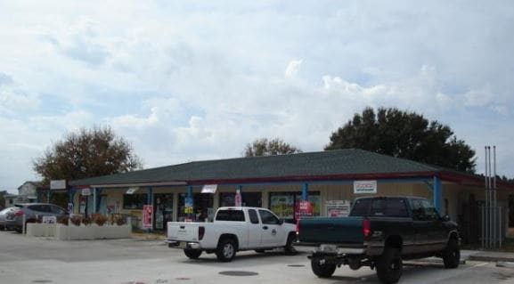
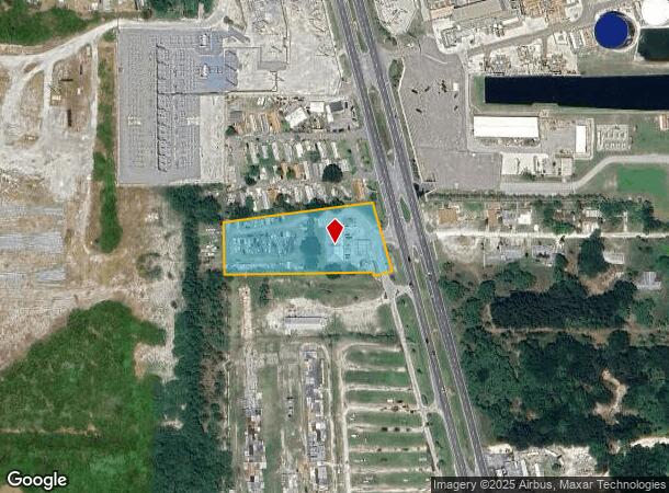
5803 N Highway 1
Palm Bay-Melbourne-Titusville, FL
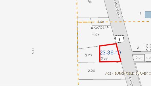
Burchfield Sb 1 Pg 115
23-36-19-02-00000.0-0002.47
PART OF LOT 2 OF SB 1 PG 115 AS DESC IN ORB 8730 PG 1781 PAR 2.24, 2.48
Servicestationmarket
Brevard
X
Florida
12009C0310H
2
2024
2.40 AC
2025
Brevard County
062106
Orlando
5,344 SF
DEMOGRAPHICS near 5803 N Highway 1
1 Mile
3 Mile
5 Mile
2024 Total Population
2,413
22,028
43,427
2029 Population
2,650
23,926
47,153
Pop Growth 2024-2029
+ 9.82%
+ 8.62%
+ 8.58%
Average Age
43
42
44
2024 Total Households
1,023
8,801
17,254
HH Growth 2024-2029
+ 9.68%
+ 8.51%
+ 8.44%
Median Household Inc
$51,792
$64,186
$79,285
Avg Household Size
2.30
2.40
2.40
2024 Avg HH Vehicles
2.00
2.00
2.00
Median Home Value
$167,415
$217,190
$255,517
Median Year Built
1980
1986
1988
Nearby Places
Map Layers
Map Styles
 Street
 Aerial
- Restaurants
- Banks
- Shops
- Fitness
- Groceries
PUBLIC TRANSPORTATION
AIRPORT
Melbourne Orlando International
DRIVE
WALK
Distance
Melbourne Orlando International
48 min
34.1 mi
Freight Ports
Port Canaveral
DRIVE
WALK
Distance
Port Canaveral
20 min
13.5 mi
Nearby Properties
Address
Land Use
TOTAL SIZE
Lot Size
Zoning
Address
Land Use
TOTAL SIZE
Lot Size
Zoning
413,008 SF
127.62 AC
GMLH
Address
Land Use
TOTAL SIZE
Lot Size
Zoning
248,110 SF
12.77 AC
Address
Land Use
TOTAL SIZE
Lot Size
Zoning
105,543 SF
16.08 AC
RU19
Address
Land Use
TOTAL SIZE
Lot Size
Zoning
73,476 SF
31.58 AC
BU1
Address
Land Use
TOTAL SIZE
Lot Size
Zoning
141,221 SF
85 AC
IU
Address
Land Use
TOTAL SIZE
Lot Size
Zoning
96,436 SF
19.10 AC
RU19
Address
Land Use
TOTAL SIZE
Lot Size
Zoning
48,555 SF
42.28 AC
IU
Address
Land Use
TOTAL SIZE
Lot Size
Zoning
95,535 SF
12.69 AC
AU
Address
Land Use
TOTAL SIZE
Lot Size
Zoning
65,645 SF
107.50 AC
GML
Address
Land Use
TOTAL SIZE
Lot Size
Zoning
89,772 SF
10.12 AC
BU1
Address
Land Use
TOTAL SIZE
Lot Size
Zoning
7,788 SF
200 AC
GML
Address
Land Use
TOTAL SIZE
Lot Size
Zoning
92,647 SF
7.02 AC
BU-2
Address
Land Use
TOTAL SIZE
Lot Size
Zoning
42,936 SF
27.69 AC
GU
Address
Land Use
TOTAL SIZE
Lot Size
Zoning
59,557 SF
7.28 AC
BU1
Address
Land Use
TOTAL SIZE
Lot Size
Zoning
73,134 SF
9 AC
PIP
Address
Land Use
TOTAL SIZE
Lot Size
Zoning
108,970 SF
22.19 AC
IU
Address
Land Use
TOTAL SIZE
Lot Size
Zoning
24,151 SF
4.62 AC
GML-H
Address
Land Use
TOTAL SIZE
Lot Size
Zoning
21,820 SF
4.32 AC
BU1
Address
Land Use
TOTAL SIZE
Lot Size
Zoning
69,044 SF
6.27 AC
PIP
Address
Land Use
TOTAL SIZE
Lot Size
Zoning
36,712 SF
1.80 AC
BU1
Address
Land Use
TOTAL SIZE
Lot Size
Zoning
19,580 SF
19.95 AC
RU24
Address
Land Use
TOTAL SIZE
Lot Size
Zoning
15,873 SF
2.02 AC
BU-1
Address
Land Use
TOTAL SIZE
Lot Size
Zoning
38,727 SF
2.38 AC
BU1
Address
Land Use
TOTAL SIZE
Lot Size
Zoning
7,454 SF
24.95 AC
GML
Address
Land Use
TOTAL SIZE
Lot Size
Zoning
16,014 SF
1.62 AC
BU1
Address
Land Use
TOTAL SIZE
Lot Size
Zoning
1,730 SF
4.10 AC
GML
Address
Land Use
TOTAL SIZE
Lot Size
Zoning
20,615 SF
6 AC
INL
Address
Land Use
TOTAL SIZE
Lot Size
Zoning
17,360 SF
3.11 AC
GML
Address
Land Use
TOTAL SIZE
Lot Size
Zoning
20,091 SF
6.54 AC
INL
Address
Land Use
TOTAL SIZE
Lot Size
Zoning
27,942 SF
20 AC
BU2
The World's #1 Commercial Real Estate Marketplace
Connect with us
© 2025 CoStar Group
The information above has been obtained from sources believed reliable. While we do not doubt its accuracy we have not verified it and make no guarantee, warranty or representation about it. It is your responsibility to independently confirm its accuracy and completeness. Any projections, opinions, assumptions, or estimates used are for example only and do not represent the current or future performance of the property. The value of this transaction to you depends on tax and other factors which should be evaluated by your tax, financial, and legal advisors. You and your advisors should conduct a careful, independent investigation of the property to determine to your satisfaction the suitability of the property for your needs.