Property Record
5803 Overseas Way, Cape Coral, FL 33914
NEARBY LISTINGS FOR SALE OR LEASE
Property Detail
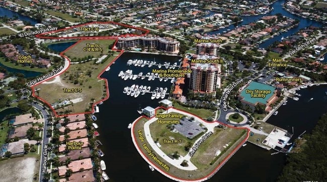
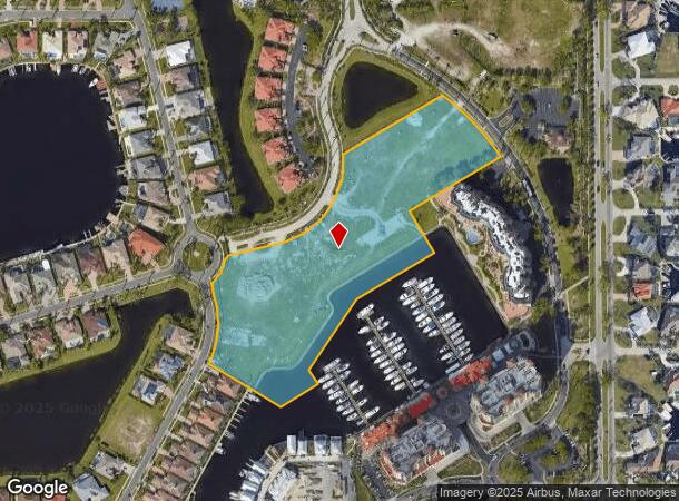
5803 Overseas Way
Cape Coral-Fort Myers, FL
West Cape Coral
21-45-23-C2-004C4.0000
META AT CAPE HAROUR PB 71 PGS 7480 TRACTS C-4 + C-5
Commercialacreage
Lee
AE
Florida
12071C0392G
6.84 AC
2024
Cape Coral
2025
Southwest Florida
010418
DEMOGRAPHICS near 5803 Overseas Way
1 Mile
3 Mile
5 Mile
2024 Total Population
5,765
38,008
104,608
2029 Population
6,989
45,676
125,157
Pop Growth 2024-2029
+ 21.23%
+ 20.17%
+ 19.64%
Average Age
57
50
50
2024 Total Households
2,823
16,747
46,657
HH Growth 2024-2029
+ 20.83%
+ 19.71%
+ 19.33%
Median Household Inc
$62,402
$71,052
$65,869
Avg Household Size
2.00
2.20
2.20
2024 Avg HH Vehicles
2.00
2.00
2.00
Median Home Value
$437,755
$368,280
$321,905
Median Year Built
1999
1995
1992
Nearby Places
Map Layers
Map Styles
 Street
 Aerial
- Restaurants
- Banks
- Shops
- Fitness
- Groceries
PUBLIC TRANSPORTATION
AIRPORT
Southwest Florida International
DRIVE
WALK
Distance
Southwest Florida International
36 min
18.6 mi
Punta Gorda
DRIVE
WALK
Distance
Punta Gorda
48 min
29.5 mi
Freight Ports
Port Manatee
DRIVE
WALK
Distance
Port Manatee
129 min
101.1 mi
SALE & LEASE HISTORY
LISTING DATE
SALE/LEASE

Aug 11, 2017
For Sale
Nearby Properties
Address
Land Use
TOTAL SIZE
Lot Size
Zoning
Address
Land Use
TOTAL SIZE
Lot Size
Zoning
441,999 SF
19.96 AC
R-3
Address
Land Use
TOTAL SIZE
Lot Size
Zoning
263,280 SF
19.99 AC
RML
Address
Land Use
TOTAL SIZE
Lot Size
Zoning
340,032 SF
30.58 AC
R1-A
Address
Land Use
TOTAL SIZE
Lot Size
Zoning
212,112 SF
33.92 AC
RD-D
Address
Land Use
TOTAL SIZE
Lot Size
Zoning
744,621 SF
8.01 AC
C1W
Address
Land Use
TOTAL SIZE
Lot Size
Zoning
158,176 SF
20 AC
R-1
Address
Land Use
TOTAL SIZE
Lot Size
Zoning
6.09 AC
MR
Address
Land Use
TOTAL SIZE
Lot Size
Zoning
135,838 SF
40 AC
R-1
Address
Land Use
TOTAL SIZE
Lot Size
Zoning
79,839 SF
8.25 AC
C1-D
Address
Land Use
TOTAL SIZE
Lot Size
Zoning
102,906 SF
2.95 AC
C
Address
Land Use
TOTAL SIZE
Lot Size
Zoning
3,327.69 AC
PR
Address
Land Use
TOTAL SIZE
Lot Size
Zoning
78,297 SF
4.62 AC
P-1
Address
Land Use
TOTAL SIZE
Lot Size
Zoning
51,610 SF
4.67 AC
C1
Address
Land Use
TOTAL SIZE
Lot Size
Zoning
42,794 SF
10.80 AC
RD-D
Address
Land Use
TOTAL SIZE
Lot Size
Zoning
49,443 SF
4.65 AC
C-1
Address
Land Use
TOTAL SIZE
Lot Size
Zoning
48,091 SF
4.61 AC
C-1
Address
Land Use
TOTAL SIZE
Lot Size
Zoning
68,340 SF
3.26 AC
R3-D
Address
Land Use
TOTAL SIZE
Lot Size
Zoning
7,020 SF
1.15 AC
R1-D
Address
Land Use
TOTAL SIZE
Lot Size
Zoning
22,098 SF
0.25 AC
C-1
Address
Land Use
TOTAL SIZE
Lot Size
Zoning
50,989 SF
1.52 AC
R3-D
Address
Land Use
TOTAL SIZE
Lot Size
Zoning
28,057 SF
5.36 AC
WSHP
Address
Land Use
TOTAL SIZE
Lot Size
Zoning
18,524 SF
1.03 AC
C1-D
Address
Land Use
TOTAL SIZE
Lot Size
Zoning
20,821 SF
5.01 AC
WSHP
Address
Land Use
TOTAL SIZE
Lot Size
Zoning
15,895 SF
1.84 AC
R1BD
Address
Land Use
TOTAL SIZE
Lot Size
Zoning
17,827 SF
1.81 AC
C1-D
Address
Land Use
TOTAL SIZE
Lot Size
Zoning
4.10 AC
RML
Address
Land Use
TOTAL SIZE
Lot Size
Zoning
3.18 AC
SC
Address
Land Use
TOTAL SIZE
Lot Size
Zoning
35,285 SF
1.40 AC
C-1
Address
Land Use
TOTAL SIZE
Lot Size
Zoning
54,073 SF
4.85 AC
C-1
The World's #1 Commercial Real Estate Marketplace
Connect with us
© 2026 CoStar Group
The information above has been obtained from sources believed reliable. While we do not doubt its accuracy we have not verified it and make no guarantee, warranty or representation about it. It is your responsibility to independently confirm its accuracy and completeness. Any projections, opinions, assumptions, or estimates used are for example only and do not represent the current or future performance of the property. The value of this transaction to you depends on tax and other factors which should be evaluated by your tax, financial, and legal advisors. You and your advisors should conduct a careful, independent investigation of the property to determine to your satisfaction the suitability of the property for your needs.