Property Record
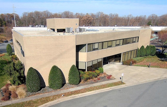
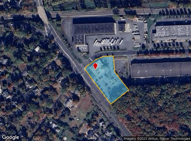
5803 Rolling Rd, Springfield, VA 22152

Current Lease Availabilities
NEARBY LISTINGS FOR SALE OR LEASE
Property Detail
5803 Rolling Rd
Washington-Arlington-Alexandria, DC-VA-MD-WV
West Springfield
0791-16-0003
WEST SPRINGFIELD BUSINESS CENTER SITE 3
Officebuilding
Fairfax
X
Virginia
5100540050D
3
2024
2.32 AC
2025
Springfield/Burke
430802
Washington, DC
18,344 SF
DEMOGRAPHICS near 5803 Rolling Rd
1 Mile
3 Mile
5 Mile
2024 Total Population
15,395
125,883
286,509
2029 Population
15,082
123,625
282,497
Pop Growth 2024-2029
(2.03%)
(1.79%)
(1.40%)
Average Age
40
41
40
2024 Total Households
5,294
41,143
93,266
HH Growth 2024-2029
(2.19%)
(1.95%)
(1.50%)
Median Household Inc
$142,230
$147,906
$143,853
Avg Household Size
2.80
3.00
2.90
2024 Avg HH Vehicles
2.00
2.00
2.00
Median Home Value
$614,239
$652,101
$662,066
Median Year Built
1972
1973
1975
Nearby Places
Map Layers
Map Styles
 Street
 Aerial
- Restaurants
- Banks
- Shops
- Fitness
- Groceries
PUBLIC TRANSPORTATION
TRANSIT/SUBWAY
Rolling Road (Manassas Line - Virginia Railway Express)
DRIVE
WALK
Distance
Rolling Road (Manassas Line - Virginia Railway Express)
2 min
15 min
0.8 mi
COMMUTER RAIL
Rolling Road (Manassas Line - Virginia Railway Express)
DRIVE
WALK
Distance
Rolling Road (Manassas Line - Virginia Railway Express)
2 min
15 min
0.8 mi
Burke Centre (Manassas Line - Virginia Railway Express)
DRIVE
WALK
Distance
Burke Centre (Manassas Line - Virginia Railway Express)
11 min
4.9 mi
AIRPORT
Ronald Reagan Washington Ntl
DRIVE
WALK
Distance
Ronald Reagan Washington Ntl
26 min
15.1 mi
Washington Dulles International
DRIVE
WALK
Distance
Washington Dulles International
42 min
21.8 mi
Baltimore/Washington International Thurgood Marshall
DRIVE
WALK
Distance
Baltimore/Washington International Thurgood Marshall
75 min
48.8 mi
Freight Ports
Port of Baltimore
DRIVE
WALK
Distance
Port of Baltimore
80 min
57.8 mi
Nearby Properties
Address
Land Use
TOTAL SIZE
Lot Size
Zoning
Address
Land Use
TOTAL SIZE
Lot Size
Zoning
1,031,040 SF
36.16 AC
220
Address
Land Use
TOTAL SIZE
Lot Size
Zoning
448,840 SF
20.13 AC
370
Address
Land Use
TOTAL SIZE
Lot Size
Zoning
485,499 SF
19.11 AC
220
Address
Land Use
TOTAL SIZE
Lot Size
Zoning
293,471 SF
13.20 AC
220
Address
Land Use
TOTAL SIZE
Lot Size
Zoning
237,214 SF
19.43 AC
460
Address
Land Use
TOTAL SIZE
Lot Size
Zoning
339,028 SF
75.81 AC
120
Address
Land Use
TOTAL SIZE
Lot Size
Zoning
124,351 SF
14.60 AC
460
Address
Land Use
TOTAL SIZE
Lot Size
Zoning
253,648 SF
10.72 AC
550
Address
Land Use
TOTAL SIZE
Lot Size
Zoning
533,660 SF
40.12 AC
303
Address
Land Use
TOTAL SIZE
Lot Size
Zoning
436,023 SF
11.20 AC
597
Address
Land Use
TOTAL SIZE
Lot Size
Zoning
92,807 SF
10.09 AC
460
Address
Land Use
TOTAL SIZE
Lot Size
Zoning
135,334 SF
12.45 AC
460
Address
Land Use
TOTAL SIZE
Lot Size
Zoning
640 SF
30.12 AC
130
Address
Land Use
TOTAL SIZE
Lot Size
Zoning
110,762 SF
10.11 AC
460
Address
Land Use
TOTAL SIZE
Lot Size
Zoning
67,970 SF
5.11 AC
460
Address
Land Use
TOTAL SIZE
Lot Size
Zoning
102,976 SF
10.75 AC
372
Address
Land Use
TOTAL SIZE
Lot Size
Zoning
39 AC
120
Address
Land Use
TOTAL SIZE
Lot Size
Zoning
71,624 SF
267.02 AC
196
Address
Land Use
TOTAL SIZE
Lot Size
Zoning
98,538 SF
8.53 AC
460
Address
Land Use
TOTAL SIZE
Lot Size
Zoning
79,745 SF
6.58 AC
400
Address
Land Use
TOTAL SIZE
Lot Size
Zoning
7.11 AC
370
Address
Land Use
TOTAL SIZE
Lot Size
Zoning
87,940 SF
8.67 AC
373
Address
Land Use
TOTAL SIZE
Lot Size
Zoning
227,757 SF
11.19 AC
560
Address
Land Use
TOTAL SIZE
Lot Size
Zoning
38,220 SF
9.33 AC
110
Address
Land Use
TOTAL SIZE
Lot Size
Zoning
167,700 SF
9.80 AC
550
Address
Land Use
TOTAL SIZE
Lot Size
Zoning
101,097 SF
8.53 AC
110
Address
Land Use
TOTAL SIZE
Lot Size
Zoning
83,096 SF
9.99 AC
110
Address
Land Use
TOTAL SIZE
Lot Size
Zoning
85,700 SF
8.17 AC
460
Address
Land Use
TOTAL SIZE
Lot Size
Zoning
87,104 SF
6.27 AC
540
Address
Land Use
TOTAL SIZE
Lot Size
Zoning
111,275 SF
10.43 AC
460
The World's #1 Commercial Real Estate Marketplace
Connect with us
© 2026 CoStar Group
The information above has been obtained from sources believed reliable. While we do not doubt its accuracy we have not verified it and make no guarantee, warranty or representation about it. It is your responsibility to independently confirm its accuracy and completeness. Any projections, opinions, assumptions, or estimates used are for example only and do not represent the current or future performance of the property. The value of this transaction to you depends on tax and other factors which should be evaluated by your tax, financial, and legal advisors. You and your advisors should conduct a careful, independent investigation of the property to determine to your satisfaction the suitability of the property for your needs.