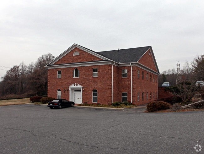
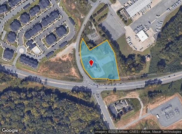
Property Record
5803 W Wilkinson Blvd, Belmont, NC 28012

NEARBY LISTINGS FOR SALE OR LEASE
Property Detail
5803 W Wilkinson Blvd
194768
16 001 036 04 000
Medicalbuilding
Gaston
X
North Carolina
3710358500J
2.97 AC
2025
Gaston County
2025
Charlotte
032301
Charlotte-Concord-Gastonia, NC-SC
7,956 SF
DEMOGRAPHICS near 5803 W Wilkinson Blvd
1 Mile
3 Mile
5 Mile
2024 Total Population
5,799
40,864
89,029
2029 Population
6,323
44,049
95,454
Pop Growth 2024-2029
+ 9.04%
+ 7.79%
+ 7.22%
Average Age
39
40
40
2024 Total Households
2,625
16,978
36,136
HH Growth 2024-2029
+ 9.41%
+ 8.01%
+ 7.43%
Median Household Inc
$68,902
$62,899
$65,976
Avg Household Size
2.20
2.30
2.40
2024 Avg HH Vehicles
2.00
2.00
2.00
Median Home Value
$237,780
$244,534
$247,885
Median Year Built
1991
1987
1988
Nearby Places
Map Layers
Map Styles
 Street
 Aerial
- Restaurants
- Banks
- Shops
- Fitness
- Groceries
PUBLIC TRANSPORTATION
COMMUTER RAIL
Gastonia Amtrak Station (Crescent - Amtrak)
DRIVE
WALK
Distance
Gastonia Amtrak Station (Crescent - Amtrak)
12 min
7.3 mi
AIRPORT
Charlotte/Douglas International
DRIVE
WALK
Distance
Charlotte/Douglas International
22 min
10.4 mi
Concord-Padgett Regional
DRIVE
WALK
Distance
Concord-Padgett Regional
36 min
26.8 mi
Freight Ports
North Charleston Terminal
DRIVE
WALK
Distance
North Charleston Terminal
236 min
205.9 mi
Nearby Properties
Address
Land Use
TOTAL SIZE
Lot Size
Zoning
Address
Land Use
TOTAL SIZE
Lot Size
Zoning
37.49 AC
Address
Land Use
TOTAL SIZE
Lot Size
Zoning
41,508 SF
29.70 AC
Address
Land Use
TOTAL SIZE
Lot Size
Zoning
1,886 SF
39.30 AC
Address
Land Use
TOTAL SIZE
Lot Size
Zoning
25,137 SF
34.81 AC
Address
Land Use
TOTAL SIZE
Lot Size
Zoning
1,066 SF
70.67 AC
PUB01
Address
Land Use
TOTAL SIZE
Lot Size
Zoning
6.09 AC
Address
Land Use
TOTAL SIZE
Lot Size
Zoning
43.38 AC
Address
Land Use
TOTAL SIZE
Lot Size
Zoning
30,906 SF
14.19 AC
Address
Land Use
TOTAL SIZE
Lot Size
Zoning
25.64 AC
Address
Land Use
TOTAL SIZE
Lot Size
Zoning
23,899 SF
14.57 AC
HC
Address
Land Use
TOTAL SIZE
Lot Size
Zoning
98.12 AC
Address
Land Use
TOTAL SIZE
Lot Size
Zoning
30,000 SF
18.87 AC
SHOP2
Address
Land Use
TOTAL SIZE
Lot Size
Zoning
78.54 AC
GR
Address
Land Use
TOTAL SIZE
Lot Size
Zoning
25.14 AC
Address
Land Use
TOTAL SIZE
Lot Size
Zoning
4,552 SF
9.22 AC
R1
Address
Land Use
TOTAL SIZE
Lot Size
Zoning
358,450 SF
23.50 AC
STOR2
Address
Land Use
TOTAL SIZE
Lot Size
Zoning
3,536 SF
12.07 AC
APT02
Address
Land Use
TOTAL SIZE
Lot Size
Zoning
190,498 SF
20.10 AC
RET05
Address
Land Use
TOTAL SIZE
Lot Size
Zoning
13,800 SF
58.55 AC
PUB01
Address
Land Use
TOTAL SIZE
Lot Size
Zoning
48,452 SF
18.08 AC
PUB03
Address
Land Use
TOTAL SIZE
Lot Size
Zoning
46,998 SF
30.47 AC
HCAR1
Address
Land Use
TOTAL SIZE
Lot Size
Zoning
2,000 SF
2.19 AC
Address
Land Use
TOTAL SIZE
Lot Size
Zoning
516,688 SF
36.23 AC
STOR2
Address
Land Use
TOTAL SIZE
Lot Size
Zoning
44,718 SF
26.53 AC
OFF10
Address
Land Use
TOTAL SIZE
Lot Size
Zoning
1,596 SF
5.73 AC
OFF01
Address
Land Use
TOTAL SIZE
Lot Size
Zoning
65,513 SF
3.07 AC
Address
Land Use
TOTAL SIZE
Lot Size
Zoning
139,155 SF
15.13 AC
RET05
Address
Land Use
TOTAL SIZE
Lot Size
Zoning
99.28 AC
BCD
Address
Land Use
TOTAL SIZE
Lot Size
Zoning
118,896 SF
3.98 AC
Address
Land Use
TOTAL SIZE
Lot Size
Zoning
21.61 AC
The World's #1 Commercial Real Estate Marketplace
Connect with us
© 2025 CoStar Group
The information above has been obtained from sources believed reliable. While we do not doubt its accuracy we have not verified it and make no guarantee, warranty or representation about it. It is your responsibility to independently confirm its accuracy and completeness. Any projections, opinions, assumptions, or estimates used are for example only and do not represent the current or future performance of the property. The value of this transaction to you depends on tax and other factors which should be evaluated by your tax, financial, and legal advisors. You and your advisors should conduct a careful, independent investigation of the property to determine to your satisfaction the suitability of the property for your needs.