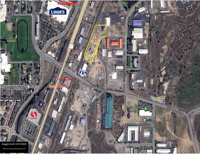
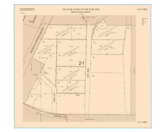
Property Record
533 Sw Veterans Way, Redmond, OR 97756
NEARBY LISTINGS FOR SALE OR LEASE
Property Detail
533 Sw Veterans Way
124166
PARCEL 2, PARTITION PLAT NO. 1991-36 4.58 AC
Industrialacreage
Deschutes
X
Oregon
41017C0325E
1.90 AC
2025
Deschutes County
2025
Portland
000901
Bend-Redmond, OR
DEMOGRAPHICS near 533 Sw Veterans Way
1 Mile
3 Mile
5 Mile
2024 Total Population
5,194
36,643
42,360
2029 Population
5,817
41,134
47,545
Pop Growth 2024-2029
+ 11.99%
+ 12.26%
+ 12.24%
Average Age
38
39
40
2024 Total Households
2,116
13,986
16,290
HH Growth 2024-2029
+ 12.10%
+ 12.41%
+ 12.43%
Median Household Inc
$60,588
$71,782
$73,751
Avg Household Size
2.40
2.60
2.60
2024 Avg HH Vehicles
2.00
2.00
2.00
Median Home Value
$405,380
$408,133
$434,012
Median Year Built
1986
1998
1998
Nearby Places
Map Layers
Map Styles
 Street
 Aerial
- Restaurants
- Banks
- Shops
- Fitness
- Groceries
PUBLIC TRANSPORTATION
AIRPORT
Roberts Field
DRIVE
WALK
Distance
Roberts Field
4 min
1.4 mi
Freight Ports
Port of Portland
DRIVE
WALK
Distance
Port of Portland
216 min
148.7 mi
SALE & LEASE HISTORY
LISTING DATE
SALE/LEASE

Mar 25, 2024
For Sale
Nearby Properties
Address
Land Use
TOTAL SIZE
Lot Size
Zoning
Address
Land Use
TOTAL SIZE
Lot Size
Zoning
22.43 AC
M1
Address
Land Use
TOTAL SIZE
Lot Size
Zoning
1 SF
22.43 AC
M1
Address
Land Use
TOTAL SIZE
Lot Size
Zoning
207,480 SF
28.78 AC
PF
Address
Land Use
TOTAL SIZE
Lot Size
Zoning
4,045 SF
10.95 AC
R5
Address
Land Use
TOTAL SIZE
Lot Size
Zoning
682.50 AC
AIRPORT
Address
Land Use
TOTAL SIZE
Lot Size
Zoning
106,239 SF
13.84 AC
PF
Address
Land Use
TOTAL SIZE
Lot Size
Zoning
106,239 SF
13.84 AC
PF
Address
Land Use
TOTAL SIZE
Lot Size
Zoning
217,211 SF
23.83 AC
C1
Address
Land Use
TOTAL SIZE
Lot Size
Zoning
4,434 SF
4.78 AC
R5
Address
Land Use
TOTAL SIZE
Lot Size
Zoning
80,000 SF
18.93 AC
PF
Address
Land Use
TOTAL SIZE
Lot Size
Zoning
165,971 SF
11.96 AC
C2
Address
Land Use
TOTAL SIZE
Lot Size
Zoning
1,584 SF
3.44 AC
R5
Address
Land Use
TOTAL SIZE
Lot Size
Zoning
102,711 SF
11.23 AC
M2
Address
Land Use
TOTAL SIZE
Lot Size
Zoning
85,512 SF
4.10 AC
R4
Address
Land Use
TOTAL SIZE
Lot Size
Zoning
37,618 SF
24.38 AC
PF-L
Address
Land Use
TOTAL SIZE
Lot Size
Zoning
50,425 SF
5.62 AC
PF
Address
Land Use
TOTAL SIZE
Lot Size
Zoning
2,560 SF
5.81 AC
R4
Address
Land Use
TOTAL SIZE
Lot Size
Zoning
297.40 AC
AIRPORT
Address
Land Use
TOTAL SIZE
Lot Size
Zoning
297.40 AC
AIRPORT
Address
Land Use
TOTAL SIZE
Lot Size
Zoning
109,112 SF
13.78 AC
C1
Address
Land Use
TOTAL SIZE
Lot Size
Zoning
14,423 SF
13.78 AC
C1
Address
Land Use
TOTAL SIZE
Lot Size
Zoning
35,943 SF
13.78 AC
Address
Land Use
TOTAL SIZE
Lot Size
Zoning
8,724 SF
13.78 AC
Address
Land Use
TOTAL SIZE
Lot Size
Zoning
16.01 AC
M1
Address
Land Use
TOTAL SIZE
Lot Size
Zoning
16.01 AC
M1
Address
Land Use
TOTAL SIZE
Lot Size
Zoning
30,000 SF
16.01 AC
M1
Address
Land Use
TOTAL SIZE
Lot Size
Zoning
5,363 SF
562.44 AC
AIRPORT
Address
Land Use
TOTAL SIZE
Lot Size
Zoning
4,125 SF
562.44 AC
AIRPORT
Address
Land Use
TOTAL SIZE
Lot Size
Zoning
4,125 SF
562.44 AC
AIRPORT
Address
Land Use
TOTAL SIZE
Lot Size
Zoning
1,200 SF
562.44 AC
AIRPORT
The World's #1 Commercial Real Estate Marketplace
Connect with us
© 2025 CoStar Group
The information above has been obtained from sources believed reliable. While we do not doubt its accuracy we have not verified it and make no guarantee, warranty or representation about it. It is your responsibility to independently confirm its accuracy and completeness. Any projections, opinions, assumptions, or estimates used are for example only and do not represent the current or future performance of the property. The value of this transaction to you depends on tax and other factors which should be evaluated by your tax, financial, and legal advisors. You and your advisors should conduct a careful, independent investigation of the property to determine to your satisfaction the suitability of the property for your needs.