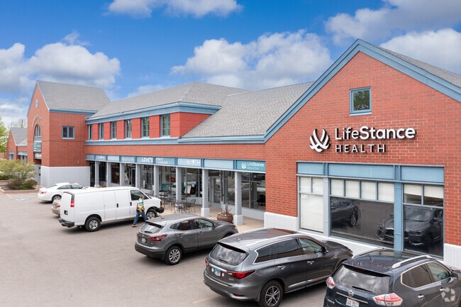
Property Record
0 2Nd St, Highland Park, IL 60035


Current Lease Availabilities
NEARBY LISTINGS FOR SALE OR LEASE
Property Detail
0 2Nd St
Chicago-Naperville-Elgin, IL-IN-WI
Mollie H Apple-S Sub
16-23-302-015
MOLLIE H APPLE-S SUBTH PT LYG N OF A LN 15FT S OF &PARL WITH CEN LN WEST PARK AVE EXTD E LOT 1
Taxexempt
Lake
X
Illinois
17097C0283L
1
0
174 SF
2024
Central North
865400
Chicago
DEMOGRAPHICS near 0 2Nd St
1 Mile
3 Mile
5 Mile
2024 Total Population
10,261
47,687
100,810
2029 Population
10,224
47,044
99,407
Pop Growth 2024-2029
(0.36%)
(1.35%)
(1.39%)
Average Age
45
43
43
2024 Total Households
4,274
18,006
36,646
HH Growth 2024-2029
(0.12%)
(1.42%)
(1.53%)
Median Household Inc
$110,200
$143,569
$156,195
Avg Household Size
2.30
2.60
2.60
2024 Avg HH Vehicles
2.00
2.00
2.00
Median Home Value
$488,367
$574,801
$658,403
Median Year Built
1965
1965
1969
Nearby Places
- Restaurants
- Banks
- Shops
- Fitness
- Groceries
PUBLIC TRANSPORTATION
COMMUTER RAIL
Highland Park Station (Union Pacific North Line - Northeast Illinois Regional Commuter Railroad (Metra))
DRIVE
WALK
Distance
Highland Park Station (Union Pacific North Line - Northeast Illinois Regional Commuter Railroad (Metra))
2 min
11 min
0.6 mi
Highwood Station (Union Pacific North Line - Northeast Illinois Regional Commuter Railroad (Metra))
DRIVE
WALK
Distance
Highwood Station (Union Pacific North Line - Northeast Illinois Regional Commuter Railroad (Metra))
2 min
1.1 mi
AIRPORT
Chicago O'Hare International
DRIVE
WALK
Distance
Chicago O'Hare International
31 min
20.6 mi
Chicago Midway International
DRIVE
WALK
Distance
Chicago Midway International
48 min
31.9 mi
Freight Ports
Port Milwaukee
DRIVE
WALK
Distance
Port Milwaukee
73 min
61.2 mi
Nearby Properties
Address
Land Use
TOTAL SIZE
Lot Size
Zoning
Address
Land Use
TOTAL SIZE
Lot Size
Zoning
244,300 SF
2.46 AC
Address
Land Use
TOTAL SIZE
Lot Size
Zoning
530,208 SF
Address
Land Use
TOTAL SIZE
Lot Size
Zoning
806,580 SF
7.64 AC
Address
Land Use
TOTAL SIZE
Lot Size
Zoning
0.57 AC
Address
Land Use
TOTAL SIZE
Lot Size
Zoning
78.54 AC
Address
Land Use
TOTAL SIZE
Lot Size
Zoning
129,900 SF
0.76 AC
Address
Land Use
TOTAL SIZE
Lot Size
Zoning
419,812 SF
13.88 AC
Address
Land Use
TOTAL SIZE
Lot Size
Zoning
534,816 SF
6.98 AC
Address
Land Use
TOTAL SIZE
Lot Size
Zoning
191,025 SF
15.66 AC
Address
Land Use
TOTAL SIZE
Lot Size
Zoning
510,213 SF
1.27 AC
Address
Land Use
TOTAL SIZE
Lot Size
Zoning
333,202 SF
13.88 AC
Address
Land Use
TOTAL SIZE
Lot Size
Zoning
79,073 SF
8.70 AC
Address
Land Use
TOTAL SIZE
Lot Size
Zoning
191,402 SF
6.92 AC
Address
Land Use
TOTAL SIZE
Lot Size
Zoning
3,896 SF
4.36 AC
Address
Land Use
TOTAL SIZE
Lot Size
Zoning
0.46 AC
Address
Land Use
TOTAL SIZE
Lot Size
Zoning
231,969 SF
1.86 AC
Address
Land Use
TOTAL SIZE
Lot Size
Zoning
131,219 SF
2.58 AC
Address
Land Use
TOTAL SIZE
Lot Size
Zoning
250,096 SF
2.16 AC
Address
Land Use
TOTAL SIZE
Lot Size
Zoning
1.37 AC
Address
Land Use
TOTAL SIZE
Lot Size
Zoning
45,091 SF
1.81 AC
Address
Land Use
TOTAL SIZE
Lot Size
Zoning
Address
Land Use
TOTAL SIZE
Lot Size
Zoning
127,191 SF
76.51 AC
Address
Land Use
TOTAL SIZE
Lot Size
Zoning
313,794 SF
6.91 AC
Address
Land Use
TOTAL SIZE
Lot Size
Zoning
74,190 SF
1.79 AC
Address
Land Use
TOTAL SIZE
Lot Size
Zoning
40,820 SF
5.79 AC
Address
Land Use
TOTAL SIZE
Lot Size
Zoning
94,920 SF
2.25 AC
Address
Land Use
TOTAL SIZE
Lot Size
Zoning
75,528 SF
7.83 AC
Address
Land Use
TOTAL SIZE
Lot Size
Zoning
109,192 SF
3.64 AC
Address
Land Use
TOTAL SIZE
Lot Size
Zoning
136,929 SF
15.35 AC
Address
Land Use
TOTAL SIZE
Lot Size
Zoning
The World's #1 Commercial Real Estate Marketplace
Connect with us
© 2025 CoStar Group
The information above has been obtained from sources believed reliable. While we do not doubt its accuracy we have not verified it and make no guarantee, warranty or representation about it. It is your responsibility to independently confirm its accuracy and completeness. Any projections, opinions, assumptions, or estimates used are for example only and do not represent the current or future performance of the property. The value of this transaction to you depends on tax and other factors which should be evaluated by your tax, financial, and legal advisors. You and your advisors should conduct a careful, independent investigation of the property to determine to your satisfaction the suitability of the property for your needs.