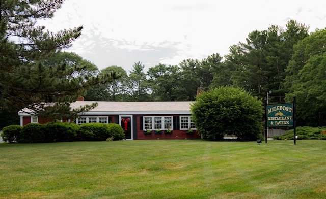
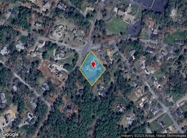
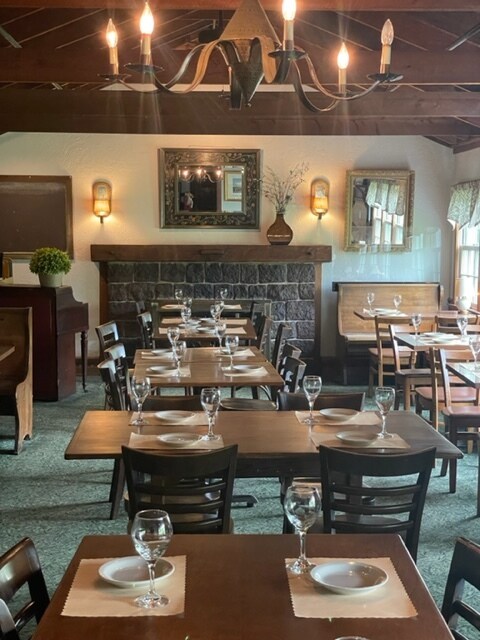
Property Record
581 Tremont St, Duxbury, MA 02332
NEARBY LISTINGS FOR SALE OR LEASE
Property Detail
581 Tremont St
DUXB-000094-000600-000014
Plymouth
Restaurantbuilding
Massachusetts
X
14
25023C0239L
1.02 AC
2025
Route 3 South
2025
Boston
507103
Boston-Cambridge-Newton, MA-NH
3,016 SF
DEMOGRAPHICS near 581 Tremont St
1 Mile
3 Mile
5 Mile
2024 Total Population
2,901
17,747
45,906
2029 Population
2,903
17,832
46,155
Pop Growth 2024-2029
+ 0.07%
+ 0.48%
+ 0.54%
Average Age
42
43
43
2024 Total Households
1,031
6,695
17,644
HH Growth 2024-2029
(0.10%)
+ 0.40%
+ 0.45%
Median Household Inc
$175,841
$125,145
$112,141
Avg Household Size
2.80
2.60
2.60
2024 Avg HH Vehicles
2.00
2.00
2.00
Median Home Value
$861,057
$688,677
$595,628
Median Year Built
1960
1971
1972
Nearby Places
Map Layers
Map Styles
 Street
 Aerial
- Restaurants
- Banks
- Shops
- Fitness
- Groceries
PUBLIC TRANSPORTATION
COMMUTER RAIL
Kingston/Route 3 (Kingston/Plymouth Line - Massachusetts Bay Transportation Authority Commuter Rail (Purple Line))
DRIVE
WALK
Distance
Kingston/Route 3 (Kingston/Plymouth Line - Massachusetts Bay Transportation Authority Commuter Rail (Purple Line))
11 min
5.0 mi
AIRPORT
General Edward Lawrence Logan International
DRIVE
WALK
Distance
General Edward Lawrence Logan International
52 min
36.6 mi
Freight Ports
Port of Boston
DRIVE
WALK
Distance
Port of Boston
50 min
34.4 mi
SALE & LEASE HISTORY
LISTING DATE
SALE/LEASE

Jun 02, 2022
For Sale
Nearby Properties
Address
Land Use
TOTAL SIZE
Lot Size
Zoning
Address
Land Use
TOTAL SIZE
Lot Size
Zoning
29.10 AC
RC
Address
Land Use
TOTAL SIZE
Lot Size
Zoning
119,308 SF
63.51 AC
PD
Address
Land Use
TOTAL SIZE
Lot Size
Zoning
28.68 AC
OS
Address
Land Use
TOTAL SIZE
Lot Size
Zoning
28.58 AC
Address
Land Use
TOTAL SIZE
Lot Size
Zoning
99,759 SF
13.11 AC
Address
Land Use
TOTAL SIZE
Lot Size
Zoning
7.40 AC
NB
Address
Land Use
TOTAL SIZE
Lot Size
Zoning
37.88 AC
RC
Address
Land Use
TOTAL SIZE
Lot Size
Zoning
8.71 AC
RC
Address
Land Use
TOTAL SIZE
Lot Size
Zoning
4.87 AC
NB
Address
Land Use
TOTAL SIZE
Lot Size
Zoning
46,674 SF
9.26 AC
Address
Land Use
TOTAL SIZE
Lot Size
Zoning
4.71 AC
RC
Address
Land Use
TOTAL SIZE
Lot Size
Zoning
18.91 AC
RC
Address
Land Use
TOTAL SIZE
Lot Size
Zoning
112,405 SF
6.67 AC
NB
Address
Land Use
TOTAL SIZE
Lot Size
Zoning
32.10 AC
PD
Address
Land Use
TOTAL SIZE
Lot Size
Zoning
65,582 SF
10.93 AC
Address
Land Use
TOTAL SIZE
Lot Size
Zoning
176,628 SF
14.95 AC
Address
Land Use
TOTAL SIZE
Lot Size
Zoning
2.41 AC
NB
Address
Land Use
TOTAL SIZE
Lot Size
Zoning
43,557 SF
3.96 AC
NB
Address
Land Use
TOTAL SIZE
Lot Size
Zoning
6,344 SF
332.81 AC
OS
Address
Land Use
TOTAL SIZE
Lot Size
Zoning
9.07 AC
RC
Address
Land Use
TOTAL SIZE
Lot Size
Zoning
59,370 SF
6.98 AC
Address
Land Use
TOTAL SIZE
Lot Size
Zoning
24,000 SF
2.55 AC
C
Address
Land Use
TOTAL SIZE
Lot Size
Zoning
2.52 AC
NB
Address
Land Use
TOTAL SIZE
Lot Size
Zoning
50,893 SF
4.33 AC
NB
Address
Land Use
TOTAL SIZE
Lot Size
Zoning
1.01 AC
RC
Address
Land Use
TOTAL SIZE
Lot Size
Zoning
91.98 AC
O
Address
Land Use
TOTAL SIZE
Lot Size
Zoning
1.60 AC
RC
Address
Land Use
TOTAL SIZE
Lot Size
Zoning
12.23 AC
PD
Address
Land Use
TOTAL SIZE
Lot Size
Zoning
600 SF
12.64 AC
RC
Address
Land Use
TOTAL SIZE
Lot Size
Zoning
3.23 AC
RC
The World's #1 Commercial Real Estate Marketplace
Connect with us
© 2026 CoStar Group
The information above has been obtained from sources believed reliable. While we do not doubt its accuracy we have not verified it and make no guarantee, warranty or representation about it. It is your responsibility to independently confirm its accuracy and completeness. Any projections, opinions, assumptions, or estimates used are for example only and do not represent the current or future performance of the property. The value of this transaction to you depends on tax and other factors which should be evaluated by your tax, financial, and legal advisors. You and your advisors should conduct a careful, independent investigation of the property to determine to your satisfaction the suitability of the property for your needs.