Property Record
581 W 235Th St, Bronx, NY 10463
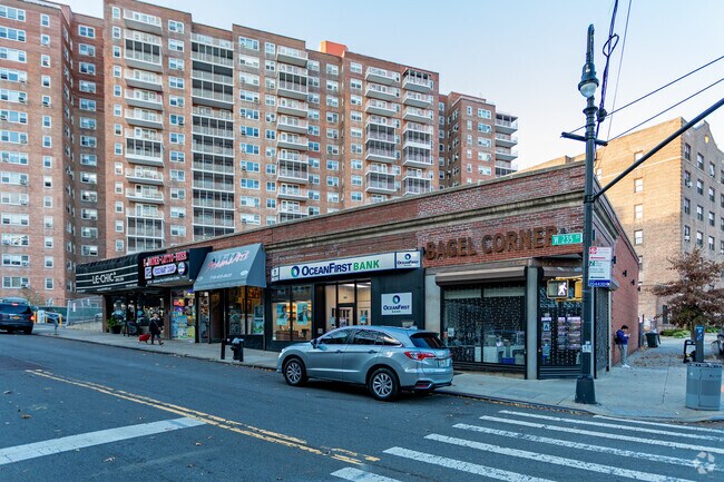

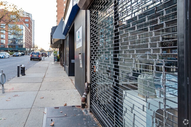
Property Detail
581 W 235Th St
05795-0546
Bronx
Storebuilding
New York
R6A
546
B and X Area of moderate flood hazard, usually the area between the limits of the 100-year and 500-year floods.
0.26 AC
2025
Bronx
2026
Westchester/So Connecticut
029700
New York-Jersey City-White Plains, NY-NJ
6,000 SF
NEARBY LISTINGS FOR SALE OR LEASE
DEMOGRAPHICS near 581 W 235Th St
1 mile
3 mile
5 mile
2025 Total Population
76,561
712,933
1,844,088
2030 Population
76,983
711,539
1,835,238
Pop Growth 2025-2030
+ 0.55%
(0.20%)
(0.48%)
Average Age
43
39
40
2025 Total Households
31,247
257,592
670,487
HH Growth 2025-2030
+ 0.39%
(0.32%)
(0.53%)
Median Household Inc
$74,815
$54,238
$55,065
Avg Household Size
2.30
2.60
2.60
2025 Avg HH Vehicles
1.00
.00
1.00
Median Home Value
$413,343
$507,872
$517,047
Median Year Built
1956
1948
1952
Nearby Places
Map Layers
Map Styles
 Street
 Aerial
Layers
 Traffic
 Biking
Places
Listings with unknown addresses are not visible on the map
- Restaurants
- Banks
- Shops
- Fitness
- Groceries
PUBLIC TRANSPORTATION
TRANSIT/SUBWAY
238 Street (1 - New York MTA Subway (The Subway))
Drive
Walk
Distance
238 Street (1 - New York MTA Subway (The Subway))
4 min
13 min
0.7 mi
231 Street (1 - New York MTA Subway (The Subway))
Drive
Walk
Distance
231 Street (1 - New York MTA Subway (The Subway))
2 min
14 min
0.7 mi
Van Cortlandt Park-242 Street (1 - New York MTA Subway (The Subway))
Drive
Walk
Distance
Van Cortlandt Park-242 Street (1 - New York MTA Subway (The Subway))
4 min
18 min
1.0 mi
COMMUTER RAIL
Spuyten Duyvil Station (Hudson Line - Metro-North Commuter Railroad Company (Metro-North))
Drive
Walk
Distance
Spuyten Duyvil Station (Hudson Line - Metro-North Commuter Railroad Company (Metro-North))
4 min
17 min
0.9 mi
Marble Hill Station (Hudson Line - Metro-North Commuter Railroad Company (Metro-North))
Drive
Walk
Distance
Marble Hill Station (Hudson Line - Metro-North Commuter Railroad Company (Metro-North))
4 min
20 min
1.1 mi
AIRPORT
LaGuardia
Drive
Walk
Distance
LaGuardia
22 min
12.3 mi
John F Kennedy International
Drive
Walk
Distance
John F Kennedy International
35 min
23.5 mi
Westchester County
Drive
Walk
Distance
Westchester County
33 min
25.1 mi
Freight Ports
NY - Red Hook Container Terminal
Drive
Walk
Distance
NY - Red Hook Container Terminal
35 min
20.5 mi
Nearby Properties
Address
Land Use
TOTAL SIZE
Lot Size
Zoning
Address
Land Use
TOTAL SIZE
Lot Size
Zoning
1,299,700 SF
29.82 AC
R6
Address
Land Use
TOTAL SIZE
Lot Size
Zoning
1,743,584 SF
77.87 AC
R6
Address
Land Use
TOTAL SIZE
Lot Size
Zoning
111.37 AC
P1
Address
Land Use
TOTAL SIZE
Lot Size
Zoning
24.08 AC
B2-A
Address
Land Use
TOTAL SIZE
Lot Size
Zoning
Address
Land Use
TOTAL SIZE
Lot Size
Zoning
481,172 SF
205.58 AC
PARK
Address
Land Use
TOTAL SIZE
Lot Size
Zoning
895,256 SF
8.32 AC
R7-1
Address
Land Use
TOTAL SIZE
Lot Size
Zoning
1,237,424 SF
21.25 AC
R6
Address
Land Use
TOTAL SIZE
Lot Size
Zoning
204,200 SF
1.68 AC
R7-1
Address
Land Use
TOTAL SIZE
Lot Size
Zoning
219.71 AC
O
Address
Land Use
TOTAL SIZE
Lot Size
Zoning
42.68 AC
P1
Address
Land Use
TOTAL SIZE
Lot Size
Zoning
100,151 SF
22.13 AC
B2
Address
Land Use
TOTAL SIZE
Lot Size
Zoning
598,815 SF
1.64 AC
R8
Address
Land Use
TOTAL SIZE
Lot Size
Zoning
39 AC
P1
Address
Land Use
TOTAL SIZE
Lot Size
Zoning
617,567 SF
3.19 AC
R7-1
Address
Land Use
TOTAL SIZE
Lot Size
Zoning
1,392,950 SF
19.67 AC
M2-1
Address
Land Use
TOTAL SIZE
Lot Size
Zoning
631,237 SF
30.93 AC
R5
Address
Land Use
TOTAL SIZE
Lot Size
Zoning
707,353 SF
29.34 AC
R6
Address
Land Use
TOTAL SIZE
Lot Size
Zoning
480,769 SF
1.21 AC
R8
Address
Land Use
TOTAL SIZE
Lot Size
Zoning
43.65 AC
PARK
Address
Land Use
TOTAL SIZE
Lot Size
Zoning
Address
Land Use
TOTAL SIZE
Lot Size
Zoning
15.76 AC
B2
Address
Land Use
TOTAL SIZE
Lot Size
Zoning
259.87 AC
PARK
Address
Land Use
TOTAL SIZE
Lot Size
Zoning
536,306 SF
1.38 AC
R8A
Address
Land Use
TOTAL SIZE
Lot Size
Zoning
393,924 SF
4.50 AC
R7-2
Address
Land Use
TOTAL SIZE
Lot Size
Zoning
4,928 SF
64.19 AC
PARK
Address
Land Use
TOTAL SIZE
Lot Size
Zoning
12.68 AC
P1
Address
Land Use
TOTAL SIZE
Lot Size
Zoning
Address
Land Use
TOTAL SIZE
Lot Size
Zoning
87,000 SF
455.70 AC
PARK
Address
Land Use
TOTAL SIZE
Lot Size
Zoning
The World's #1 Commercial Real Estate Marketplace
Connect with us
© 2026 CoStar Group
The information above has been obtained from sources believed reliable. While we do not doubt its accuracy we have not verified it and make no guarantee, warranty or representation about it. It is your responsibility to independently confirm its accuracy and completeness. Any projections, opinions, assumptions, or estimates used are for example only and do not represent the current or future performance of the property. The value of this transaction to you depends on tax and other factors which should be evaluated by your tax, financial, and legal advisors. You and your advisors should conduct a careful, independent investigation of the property to determine to your satisfaction the suitability of the property for your needs.