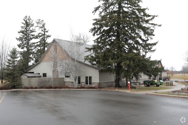
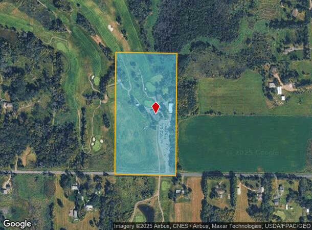
Property Record
5810 190Th St N, Forest Lake, MN 55025
NEARBY LISTINGS FOR SALE OR LEASE
Property Detail
5810 190Th St N
29-032-21-34-0001
EAST2 SE4 SW4 SEC29 TWP32N RNG21W
Commercialnec
Washington
X
Minnesota
27163C0126E
19.93 AC
2025
Maplewood
2024
Minneapolis/St Paul
070107
Minneapolis-St. Paul-Bloomington, MN-WI
6,940 SF
DEMOGRAPHICS near 5810 190Th St N
1 Mile
3 Mile
5 Mile
2024 Total Population
941
10,726
35,554
2029 Population
1,035
11,624
38,438
Pop Growth 2024-2029
+ 9.99%
+ 8.37%
+ 8.11%
Average Age
37
39
39
2024 Total Households
344
4,156
13,790
HH Growth 2024-2029
+ 10.17%
+ 8.52%
+ 8.25%
Median Household Inc
$74,558
$80,168
$97,794
Avg Household Size
2.80
2.50
2.50
2024 Avg HH Vehicles
2.00
2.00
2.00
Median Home Value
$455,882
$361,920
$360,735
Median Year Built
2007
1998
1995
Nearby Places
Map Layers
Map Styles
 Street
 Aerial
- Restaurants
- Banks
- Shops
- Fitness
- Groceries
PUBLIC TRANSPORTATION
AIRPORT
Minneapolis-St Paul International/Wold-Chamberlain
DRIVE
WALK
Distance
Minneapolis-St Paul International/Wold-Chamberlain
48 min
31.2 mi
Nearby Properties
Address
Land Use
TOTAL SIZE
Lot Size
Zoning
Address
Land Use
TOTAL SIZE
Lot Size
Zoning
317,520 SF
22.87 AC
Address
Land Use
TOTAL SIZE
Lot Size
Zoning
39,032 SF
12.34 AC
Address
Land Use
TOTAL SIZE
Lot Size
Zoning
93,292 SF
Address
Land Use
TOTAL SIZE
Lot Size
Zoning
54,507 SF
8.63 AC
Address
Land Use
TOTAL SIZE
Lot Size
Zoning
64,903 SF
7.83 AC
Address
Land Use
TOTAL SIZE
Lot Size
Zoning
77,637 SF
5.43 AC
Address
Land Use
TOTAL SIZE
Lot Size
Zoning
103,200 SF
13.20 AC
Address
Land Use
TOTAL SIZE
Lot Size
Zoning
71,450 SF
Address
Land Use
TOTAL SIZE
Lot Size
Zoning
66,155 SF
6.51 AC
Address
Land Use
TOTAL SIZE
Lot Size
Zoning
66,084 SF
7.30 AC
Address
Land Use
TOTAL SIZE
Lot Size
Zoning
114,251 SF
7.58 AC
Address
Land Use
TOTAL SIZE
Lot Size
Zoning
74,178 SF
5.02 AC
Address
Land Use
TOTAL SIZE
Lot Size
Zoning
1,052 SF
140.60 AC
Address
Land Use
TOTAL SIZE
Lot Size
Zoning
2,416 SF
23.11 AC
Address
Land Use
TOTAL SIZE
Lot Size
Zoning
81,248 SF
1.07 AC
Address
Land Use
TOTAL SIZE
Lot Size
Zoning
67,616 SF
Address
Land Use
TOTAL SIZE
Lot Size
Zoning
95,384 SF
13.40 AC
Address
Land Use
TOTAL SIZE
Lot Size
Zoning
56,120 SF
3.44 AC
Address
Land Use
TOTAL SIZE
Lot Size
Zoning
51,860 SF
78.12 AC
Address
Land Use
TOTAL SIZE
Lot Size
Zoning
15,850 SF
23.79 AC
Address
Land Use
TOTAL SIZE
Lot Size
Zoning
45,576 SF
Address
Land Use
TOTAL SIZE
Lot Size
Zoning
46,800 SF
2.55 AC
Address
Land Use
TOTAL SIZE
Lot Size
Zoning
49,224 SF
2.50 AC
Address
Land Use
TOTAL SIZE
Lot Size
Zoning
49,224 SF
2.32 AC
Address
Land Use
TOTAL SIZE
Lot Size
Zoning
44,226 SF
2.49 AC
Address
Land Use
TOTAL SIZE
Lot Size
Zoning
2,130 SF
25.48 AC
Address
Land Use
TOTAL SIZE
Lot Size
Zoning
48,439 SF
4.82 AC
Address
Land Use
TOTAL SIZE
Lot Size
Zoning
139,610 SF
7.96 AC
Address
Land Use
TOTAL SIZE
Lot Size
Zoning
39,195 SF
Address
Land Use
TOTAL SIZE
Lot Size
Zoning
24,498 SF
4.49 AC
The World's #1 Commercial Real Estate Marketplace
Connect with us
© 2025 CoStar Group
The information above has been obtained from sources believed reliable. While we do not doubt its accuracy we have not verified it and make no guarantee, warranty or representation about it. It is your responsibility to independently confirm its accuracy and completeness. Any projections, opinions, assumptions, or estimates used are for example only and do not represent the current or future performance of the property. The value of this transaction to you depends on tax and other factors which should be evaluated by your tax, financial, and legal advisors. You and your advisors should conduct a careful, independent investigation of the property to determine to your satisfaction the suitability of the property for your needs.